Yekatit: Difference between revisions
Jump to navigation
Jump to search
mNo edit summary |
mNo edit summary |
||
| Line 157: | Line 157: | ||
|Mar low C = 13.5 | |Mar low C = 13.5 | ||
|Apr low C = 15.0 | |Apr low C = 15.0 | ||
|May low C = 15. | |May low C = 15.4 | ||
|Jun low C = 15.4 | |Jun low C = 15.4 | ||
|Jul low C = 16.0 | |Jul low C = 16.0 | ||
|Aug low C = 15.5 | |Aug low C = 15.5 | ||
|Sep low C = 15.5 | |Sep low C = 15.5 | ||
|Oct low C = 15. | |Oct low C = 15.3 | ||
|Nov low C = 15.2 | |Nov low C = 15.2 | ||
|Dec low C = 13.0 | |Dec low C = 13.0 | ||
| Line 170: | Line 170: | ||
|Mar mean C = 18.4 | |Mar mean C = 18.4 | ||
|Apr mean C = 19.9 | |Apr mean C = 19.9 | ||
|May mean C = 20. | |May mean C = 20.8 | ||
|Jun mean C = 22.4 | |Jun mean C = 22.4 | ||
|Jul mean C = 24.8 | |Jul mean C = 24.8 | ||
|Aug mean C = 23.6 | |Aug mean C = 23.6 | ||
|Sep mean C = 22.4 | |Sep mean C = 22.4 | ||
|Oct mean C = 20. | |Oct mean C = 20.7 | ||
|Nov mean C = 19.6 | |Nov mean C = 19.6 | ||
|Dec mean C = 18.5 | |Dec mean C = 18.5 | ||
Revision as of 17:26, 27 February 2024
Yekatit | |
|---|---|
|
Flag | |
 | |
| Area | |
• Total | 204,787.96 km2 (79,069.07 sq mi) |
| Population | |
• Estimate | 28,659,000 |
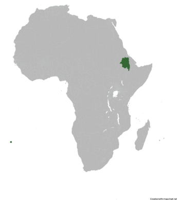
Yekatit officially the Democratic Republic of Yekatit is a country located in the Horn of Africa. It borders the disputed area of Ertra by the north, Ethiopian regions of Benishangul-Gumuz and Oromia, Afar by the east and South Sudan by the west. With a total area of 204,787.96 km2, Yekatit is a country with a rich history and culture.
| Climate data for insert location | |||||||||||||
|---|---|---|---|---|---|---|---|---|---|---|---|---|---|
| Month | Jan | Feb | Mar | Apr | May | Jun | Jul | Aug | Sep | Oct | Nov | Dec | Year |
| Average high °C (°F) | 21.3 (70.3) |
22.6 (72.7) |
23.3 (73.9) |
24.8 (76.6) |
26.2 (79.2) |
29.4 (84.9) |
33.7 (92.7) |
31.8 (89.2) |
29.3 (84.7) |
26.2 (79.2) |
24.1 (75.4) |
24.1 (75.4) |
26.4 (79.5) |
| Daily mean °C (°F) | 17.1 (62.8) |
17.9 (64.2) |
18.4 (65.1) |
19.9 (67.8) |
20.8 (69.4) |
22.4 (72.3) |
24.8 (76.6) |
23.6 (74.5) |
22.4 (72.3) |
20.7 (69.3) |
19.6 (67.3) |
18.5 (65.3) |
20.5 (68.9) |
| Average low °C (°F) | 13.0 (55.4) |
13.3 (55.9) |
13.5 (56.3) |
15.0 (59.0) |
15.4 (59.7) |
15.4 (59.7) |
16.0 (60.8) |
15.5 (59.9) |
15.5 (59.9) |
15.3 (59.5) |
15.2 (59.4) |
13.0 (55.4) |
14.7 (58.4) |
| Average precipitation mm (inches) | 189.0 (7.44) |
356.0 (14.02) |
204.0 (8.03) |
43.0 (1.69) |
36.0 (1.42) |
25.0 (0.98) |
18.0 (0.71) |
57.0 (2.24) |
94.0 (3.70) |
126.0 (4.96) |
133.0 (5.24) |
265.0 (10.43) |
1,546 (60.86) |
| Source: [NAME OF THE WEBSITE] | |||||||||||||
