Midribbonia: Difference between revisions
Jump to navigation
Jump to search
Midribbonia (talk | contribs) (Created page with "{{Infobox country |micronation = <!--yes if a micronation--> |conventional_long_name = Directorial Republic of Midribbonia |native_name = Midribba |common_name = Midribbonia |status = <!-- <gallery> Example.jpg|Caption1 Example.jpg|Caption2 </gallery> --> |image_flag = frameless |image_coat = frameless |national_motto = 'Ad Maius Bonum' |englishmotto = For The Grea...") |
Midribbonia (talk | contribs) mNo edit summary |
||
| Line 10: | Line 10: | ||
</gallery> | </gallery> | ||
--> | --> | ||
|image_flag = [[File: | |image_flag = | ||
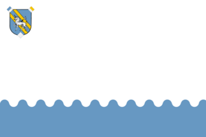
|image_coat = [[File: | [[File:MidribbFlagSmall.png|frameless|The flag features a white field with light blue wave pattern in its lower third. In the upper left corner there is the CoA of Midribbonia.]] | ||
|image_coat = | |||
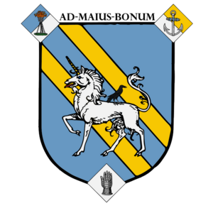
[[File:MidribbCoASmall.png|frameless|The Coat of Arms is a light blue shield with two diagonal golden stripes crossing it from the top left to the bottom right corner. The three sharp corners of the shield are covered with diamonds, featuring a torch (top left corner), an anchor (top right corner) and a knight's hand (bottom centre). In the centre of the main shield there is a white unicorn with a golden horn, on top of whose back sits a black raven.]] | |||
|national_motto = 'Ad Maius Bonum' | |national_motto = 'Ad Maius Bonum' | ||
|englishmotto = For The Greater Good | |englishmotto = For The Greater Good | ||
|national_anthem = 'In Times of Need' | |national_anthem = 'In Times of Need' | ||
|image_map = [[File: | |image_map = [[File:MidribbMapThin.png|frameless]] | ||
|loctext = north-eastern Ardentia, south-west of Patima Sea | |loctext = north-eastern Ardentia, south-west of Patima Sea | ||
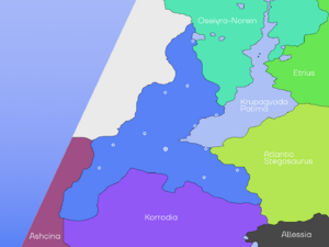
|map_caption = Midribbonia and its immediate neigbours: Korrodia, Atlantic Stegosaurus, | |map_caption = Midribbonia and its immediate neigbours: Korrodia, Atlantic Stegosaurus, Oseiyra-Norein and Ashcina. The secondary neighbour, Allessia, is also visible. | ||
|capital = Hermanburg | |capital = Hermanburg | ||
|coordinates = <!-- Coordinates for capital, using {{tl|coord}} --> | |coordinates = <!-- Coordinates for capital, using {{tl|coord}} --> | ||
Latest revision as of 18:49, 23 April 2024
Directorial Republic of Midribbonia Midribba | |
|---|---|
| Motto: 'Ad Maius Bonum' For The Greater Good | |
| Anthem: 'In Times of Need' | |
 Midribbonia and its immediate neigbours: Korrodia, Atlantic Stegosaurus, Oseiyra-Norein and Ashcina. The secondary neighbour, Allessia, is also visible. | |
| Location | north-eastern Ardentia, south-west of Patima Sea |
| Capital and largest city | Hermanburg |
| Official languages | Ribbonian, Kalranian Common |
| Recognised regional languages | Karpianian, Ephrurgian, Didanian |
| Ethnic groups | Human - 96%, Feline - 3.9%, 0.1% - Pure Mind |
| Demonym(s) | Midribbonian, Ribbonian |
| Government | Unitary presidential democratic republic |
• Director | Volshtag Kratov |
• Vice Director | Catherine Gromov |
| Legislature | National Assembly |
| House of Provinces | |
| House of Representatives | |
| Establishment | |
• Duchy of Bashunor is founded | 859 CE |
• Duchy of Framdahen is founded | 892 CE |
• Republic of Bashunor is formed | 1097 CE |
• City of Bashunor is destroyed | 1539 CE |
• First Ribbonian Kingdom is formed | 1542 CE |
• First Ribbonian Kingdom is dissolved | 1775 CE |
• Directorial Republic of Midribbonia is formed | 1996 CE |
| Area | |
• | 1,436,766 km2 (554,738 sq mi)exc. Mavony Isles (37) |
| Population | |
• 2014 estimate | 165,300,000 |
| GDP (nominal) | 2014 estimate |
• Total | 315,000,000,000 |
• Per capita | 1,909 |
| Gini (2014) | 34 medium |
| Currency | croset ((CrM?)) |
| Date format | Common Era (CE), dd/mm/yyyy |
| Driving side | right |
| Calling code | +368 |
| Internet TLD | .rib |

