Upper Norlands: Difference between revisions
NeviersiaUDR (talk | contribs) (Created page with "{{wip}}{{Infobox political division | name = Upper Norlands | native_name = ''Mongamulougimato'' | settlement_type = Region | image_skyline = | imagesize = | image_caption = | image_flag = | flag_size = | flag_link = | image_seal = | seal_size = | seal_type = | seal_link = | etymology = | nickname = | motto = | image_map = 300px | map_caption = Location of Northern Lainerov...") |
NeviersiaUDR (talk | contribs) m (Added to SN category.) |
||
| (One intermediate revision by the same user not shown) | |||
| Line 16: | Line 16: | ||
| nickname = | | nickname = | ||
| motto = | | motto = | ||
| image_map = [[File: | | image_map = [[File:Upper Norlands in South Neviersia.png|300px]] | ||
| map_caption = Location of | | map_caption = Location of the Upper Norlands in [[South Neviersia]] | ||
|subdivision_type = Country | |subdivision_type = Country | ||
|subdivision_name = {{flag|South Neviersia}} | |subdivision_name = {{flag|South Neviersia}} | ||
| Line 155: | Line 155: | ||
==Education== | ==Education== | ||
==Sport== | ==Sport== | ||
[[Category:South Neviersia]] | |||
Latest revision as of 13:20, 6 May 2024
This article is incomplete because it is pending further input from participants, or it is a work-in-progress by one author. Please comment on this article's talk page to share your input, comments and questions. Note: To contribute to this article, you may need to seek help from the author(s) of this page. |
Upper Norlands Mongamulougimato | |
|---|---|
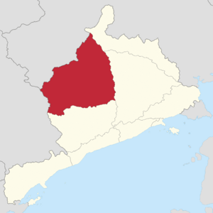
 Location of the Upper Norlands in South Neviersia | |
| Country | |
| Territory status | 1 September 1863 |
| Declared as Province | 13 July 1910 |
| Home Rule Agreement | 25 November 1992 |
| Capital and largest city | Kilbrinagh |
| Demonym(s) | Upper Norlander |
| Government | |
• Premier | Valoura Aurolyaois (Libertarian) |
| Legislature | Upper Norlands Authority |
| Area | |
• Total | 189,336 km2 (73,103 sq mi) |
| Population | |
• 2024 estimate | 1,496,000 |
• Density | 7.9/km2 (20.5/sq mi) |
| GDP (nominal) | 2021 estimate |
• Total | $47.8 billion (9th) |
• Per capita | $32,000 (9th) |
| HDI (2023) | 0.861 very high |
| Time zone | UTC+14 (Central Veropan Time) |
| Postal abbreviation | UN |
| ISO 3166 code | SN-UN |
| Website | uppernorlands.gov.sn |
The Upper Norlands (Te Rova Lainer: Mongamulougimato, lit. "northern highlands"; abbreviated to UN) is a region of South Neviersia. It shares borders with the Neviersian region of Lower Norlands to the northwest, Northern Lainerova to the northeast, Midland Region to the east, Perth Country to the south and Manima to the west. The regional capital and largest city is Kilbrinagh. The Upper Norlands is the largest region by land area in South Neviersia.
History
Geography
Climate
The northside of Upper Norlands has a monsoon-influenced humid subtropical climate (Cwa) according to the Köppen climate classification system. In the southside, the climate becomes more alpine due to higher altitudes.
Governance
The Upper Norlands Authority is the regional authority for the Upper Norlands.
Economy
Torlowpolis and Kilbrinagh are the two regional economic centres of the Upper Norlands.
Demography
As of 2024, there are an estimated 1,496,000 inhabitants residing in the Upper Norlands, the lowest of any region. Kilbrinagh is the only city in the region with 164,000 residents. Other major urban centres include Torlowpolis (89,000), Fort Kyaois (77,000) and Yostedal (56,000). The majority of Upper Norlanders live in the southside of the region.
Ethnicity
The majority of Upper Norlanders are native Lainerovans/Lainers, with more than 80% declaring the ethnicity in Census. At the 2024 census, the ethnicities of Northern Lainerova were as follows (ethnicities add to more than 100% as citizens could choose more than one ethnic group):
| Ethnic group | Percentage |
|---|---|
| Lainerovan/Lainer | 81.9 |
| Asana | 33.5 |
| Larishoma | 39.4 |
| Sortoma | 5.4 |
| Other Lainerovan/Lainer | 3.6 |
| European | 11.1 |
| Asian | 13.2 |
| Pacific Islander | 0.9 |
| ME/LA/African | 1.2 |
| Other | 2.4 |
| No answer/invalid | 3.2 |