Taīga-Kaidō Plain: Difference between revisions
(Created page with "{{template:WIP}} {{Infobox country |micronation = <!--yes if a micronation--> |conventional_long_name = Taīga-Kaidō Plain |native_name = 体伊賀・海道大圏 |common_name = <!--Common name in English (used for wikilinks, captions, and to produce a default iso3166 code)--> |status = <!--Status of country--> |image_flag = <!--e.g. Flag of country.svg--> |alt_flag = <!--alt text for flag (text shown when pointer hover...") |
No edit summary |
||
| (2 intermediate revisions by the same user not shown) | |||
| Line 71: | Line 71: | ||
|area_rank = | |area_rank = | ||
|area = <!--Major area size (in [[Template:convert]] either km2 or sqmi first)--> | |area = <!--Major area size (in [[Template:convert]] either km2 or sqmi first)--> | ||
|area_km2 = | |area_km2 = 19000 | ||
|area_sq_mi = | |area_sq_mi = 7330 | ||
|area_footnote = <!--Optional footnote for area--> | |area_footnote = <!--Optional footnote for area--> | ||
|percent_water = | |percent_water = | ||
| Line 83: | Line 83: | ||
|population_census = | |population_census = | ||
|population_census_year = | |population_census_year = | ||
|population_density_km2 = 1, | |population_density_km2 = 1,630 | ||
|population_density_sq_mi = | |population_density_sq_mi = 4,230 | ||
|population_density_rank = | |population_density_rank = | ||
|nummembers = <!--An alternative to population for micronation--> | |nummembers = <!--An alternative to population for micronation--> | ||
| Line 126: | Line 126: | ||
|footnotes = <!--For any generic non-numbered footnotes--> | |footnotes = <!--For any generic non-numbered footnotes--> | ||
}} | }} | ||
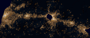
The '''Taīga-Kaidō Plain''', also known as the '''Taīga-Kaidō Megalopolis''' or the '''Kaigan-Kaigan Corridor''' is a stretch of almost entirely urbanized land in [[Tayichi]] extending from [[Shuto]] in the west to [[Kojima]] in the east. The urbanization runs mostly along the [[Taīga]] and [[Kaidō]] Rivers and is centered around road and rail corridors that run alongside them. A view of Tayichi at night shows a rather dense and continuous strip of light (demarcating urban zones) that delineates the region, a starch contrast to the [[Sōdai|dark mountains that mostly surround it]]. It encompasses [[Fachi]] and [[Samui]] provinces, the Shuto and [[Idaina]] Metropolitan Districts, as well as parts of [[Gyoson]] and [[Kitai]] provinces. With a total estimated population of around 31 million, slightly less than half of Tayichi's entire population, and a nominal GDP of $1.850 trillion, it is one of the largest and richest urban areas on the planet. | |||
The term was first used the 1950s to describe the rapidly interconnecting middle section of [[Hashita]], where cities due to common transport infrastructure such as rivers and railways began merging together to form larger clusters. During the Tayichian Industrial Revolution in the 19th century, this was the first area of the country to undergo rapid industrialization and urbanization. Today, the Taīga-Kaidō Plain hosts the majority of the nation's industrial and economic capabilites, as well as the seat of government. Since 1964, Toshibu Shinkansen services run along the corridor, and the region itself gained the nickname "The Lifeline of Tayichi" | |||
[[Category:Lands End]] | [[Category:Lands End]] | ||
Latest revision as of 09:55, 23 June 2024
This article is incomplete because it is pending further input from participants, or it is a work-in-progress by one author. Please comment on this article's talk page to share your input, comments and questions. Note: To contribute to this article, you may need to seek help from the author(s) of this page. |
Taīga-Kaidō Plain 体伊賀・海道大圏 | |
|---|---|
 Satellite iamge of the Taīga-Kaidō Megalopolis at night | |
| Largest City | Shuto |
| Area | |
• | 19,000 km2 (7,300 sq mi) |
| Population | |
• 2024 estimate | 31,000,000 |
• Density | 1,630/km2 (4,221.7/sq mi) |
| GDP (nominal) | 2024 estimate |
• Total | $1.850 trillion |
• Per capita | $59,670 |
The Taīga-Kaidō Plain, also known as the Taīga-Kaidō Megalopolis or the Kaigan-Kaigan Corridor is a stretch of almost entirely urbanized land in Tayichi extending from Shuto in the west to Kojima in the east. The urbanization runs mostly along the Taīga and Kaidō Rivers and is centered around road and rail corridors that run alongside them. A view of Tayichi at night shows a rather dense and continuous strip of light (demarcating urban zones) that delineates the region, a starch contrast to the dark mountains that mostly surround it. It encompasses Fachi and Samui provinces, the Shuto and Idaina Metropolitan Districts, as well as parts of Gyoson and Kitai provinces. With a total estimated population of around 31 million, slightly less than half of Tayichi's entire population, and a nominal GDP of $1.850 trillion, it is one of the largest and richest urban areas on the planet.
The term was first used the 1950s to describe the rapidly interconnecting middle section of Hashita, where cities due to common transport infrastructure such as rivers and railways began merging together to form larger clusters. During the Tayichian Industrial Revolution in the 19th century, this was the first area of the country to undergo rapid industrialization and urbanization. Today, the Taīga-Kaidō Plain hosts the majority of the nation's industrial and economic capabilites, as well as the seat of government. Since 1964, Toshibu Shinkansen services run along the corridor, and the region itself gained the nickname "The Lifeline of Tayichi"