Sōdai: Difference between revisions
No edit summary |
No edit summary |
||
| (2 intermediate revisions by the same user not shown) | |||
| Line 43: | Line 43: | ||
| age = | | age = | ||
| geology = | | geology = | ||
| volcanic_arc = Kaikin | | volcanic_arc = Kaikin | ||
| volcanic_belt = | | volcanic_belt = TBD | ||
| volcanic_field = Tayichian Eastern | | volcanic_field = Tayichian Eastern | ||
| volcanic_arc/belt = | | volcanic_arc/belt = | ||
| Line 55: | Line 55: | ||
| embedded = | | embedded = | ||
}} | }} | ||
The '''Sōdai''' | The '''Sōdai''' is the highest and most extensive mountain range in the Tayichian Isles. stretching approximately TBD km (TBD mi) across the entire eastern seaboard of Hashita, form Yamashū in [[Nanpogasi]] to Horonobe in [[Miyagi]]. [[Mount Seito]], its highest peak at 4,478 m is located in the central area of Nanpogasi province, in the southern section of the mountain range, while the Sōdai in their entirety have 78 peaks higher than 4,000m. | ||
The mountains were formed over millions of years as the A and B tectonic plates (cough cough Hoos). This also resulted in marine sedimentary rock by thrusting and folding into high mountain peaks, making the Sōdai rich in rock such as dolomite. The altitude and size of the range affect the climate of Hashita, causing drastic differences in temperature and precipitation between the lower western and higher eastern section of the island. The Sōdai is home to several endemic species of plants and animals as a result as well. | The mountains were formed over millions of years as the A and B tectonic plates (cough cough Hoos). This also resulted in marine sedimentary rock by thrusting and folding into high mountain peaks, making the Sōdai rich in rock such as dolomite. The altitude and size of the range affect the climate of Hashita, causing drastic differences in temperature and precipitation between the lower western and higher eastern section of the island. The Sōdai is home to several endemic species of plants and animals as a result as well. | ||
People living in the Sōdai regions, which is usually used to describe the Nanpogasi and [[Kitagasi]] provinces have developed a distinct cultural identity to the rest of the island. The mountains are still home to some traditional practices such as alpine transhumance, cheesemaking and woodworking, while the region also became a hub for tourism, specifically winter tourism, over the last decades, with over 800 ski resorts dotted across the mountain range. | People living in the Sōdai regions, which is usually used to describe the Nanpogasi and [[Kitagasi]] provinces, but also to some extent the eastern coast of [[Miyagi]], have developed a distinct cultural identity to the rest of the island. The mountains are still home to some traditional practices such as alpine transhumance, cheesemaking and woodworking, while the region also became a hub for tourism, specifically winter tourism, over the last decades, with over 800 ski resorts dotted across the mountain range. | ||
[[Category:Lands End]] | [[Category:Lands End]] | ||
Latest revision as of 11:31, 27 June 2024
This article is incomplete because it is pending further input from participants, or it is a work-in-progress by one author. Please comment on this article's talk page to share your input, comments and questions. Note: To contribute to this article, you may need to seek help from the author(s) of this page. |
| Sōdai | |
|---|---|
壮大山脈 | |
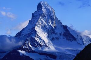
 Mount Seito, the tallest peak of the Sōdai Mountains, Nanpogasi | |
| Highest point | |
| Elevation | 4,478 m (14,692 ft) Mount Seito |
| Coordinates | TBD |
| Geology | |
| Volcanic arc | Kaikin |
| Last eruption | 2021 |
The Sōdai is the highest and most extensive mountain range in the Tayichian Isles. stretching approximately TBD km (TBD mi) across the entire eastern seaboard of Hashita, form Yamashū in Nanpogasi to Horonobe in Miyagi. Mount Seito, its highest peak at 4,478 m is located in the central area of Nanpogasi province, in the southern section of the mountain range, while the Sōdai in their entirety have 78 peaks higher than 4,000m.
The mountains were formed over millions of years as the A and B tectonic plates (cough cough Hoos). This also resulted in marine sedimentary rock by thrusting and folding into high mountain peaks, making the Sōdai rich in rock such as dolomite. The altitude and size of the range affect the climate of Hashita, causing drastic differences in temperature and precipitation between the lower western and higher eastern section of the island. The Sōdai is home to several endemic species of plants and animals as a result as well.
People living in the Sōdai regions, which is usually used to describe the Nanpogasi and Kitagasi provinces, but also to some extent the eastern coast of Miyagi, have developed a distinct cultural identity to the rest of the island. The mountains are still home to some traditional practices such as alpine transhumance, cheesemaking and woodworking, while the region also became a hub for tourism, specifically winter tourism, over the last decades, with over 800 ski resorts dotted across the mountain range.