Ivelboria: Difference between revisions
Jump to navigation
Jump to search
NeviersiaUDR (talk | contribs) (Created page with "{{wip}} {{Infobox country |micronation = <!--yes if a micronation--> |conventional_long_name = Commonwealth of Ivelboria |native_name = Kommunvelt o Ivelbor (Ivelborian) |common_name = Ivelboria |status = <!--Status of country--> |image_flag = Flag of Neviersia.png |alt_flag = <!--alt text for flag (text shown when pointer hovers over flag)--> |flag_border = <!--set to no to disable border around the flag--> |ima...") |
NeviersiaUDR (talk | contribs) mNo edit summary |
||
| Line 31: | Line 31: | ||
|map_caption2 = <!--Caption to place below second map--> | |map_caption2 = <!--Caption to place below second map--> | ||
|image_map2_size = <!--Map size in number of pixels--> | |image_map2_size = <!--Map size in number of pixels--> | ||
|capital = [[Djurma]]<br><small>[[File:WMA_button2b.png|15px]] | |capital = [[Djurma]]<br><small>[[File:WMA_button2b.png|15px]] 19°42′39″S 173°12′23″W</small> | ||
|coordinates = <!-- Coordinates for capital, using {{tl|coord}} --> | |coordinates = <!-- Coordinates for capital, using {{tl|coord}} --> | ||
|largest_city = [[Djurma]]<br><small>[[File:WMA_button2b.png|15px]] | |largest_city = [[Djurma]]<br><small>[[File:WMA_button2b.png|15px]] 19°42′39″S 173°12′23″W</small> | ||
|largest_settlement_type = <!--Type of settlement if largest settlement not a city--> | |largest_settlement_type = <!--Type of settlement if largest settlement not a city--> | ||
|largest_settlement = <!--Name of largest settlement--> | |largest_settlement = <!--Name of largest settlement--> | ||
| Line 98: | Line 98: | ||
|GDP_nominal_per_capita = | |GDP_nominal_per_capita = | ||
|GDP_nominal_per_capita_rank = | |GDP_nominal_per_capita_rank = | ||
|Gini = | |Gini = 29.6 | ||
|Gini_ref = <!--(for any ref/s to associate with Gini number)--> | |Gini_ref = <!--(for any ref/s to associate with Gini number)--> | ||
|Gini_rank = | |Gini_rank = | ||
|Gini_year = | |Gini_year = 2023 | ||
|HDI_year = | |HDI_year = 2023 | ||
|HDI = | |HDI = 0.892 | ||
|HDI_change = | |HDI_change = increase | ||
|HDI_rank = | |HDI_rank = | ||
|HDI_ref = <!--(for any ref/s to associate with HDI number)--> | |HDI_ref = <!--(for any ref/s to associate with HDI number)--> | ||
| Line 115: | Line 115: | ||
|DST_note = <!--Optional note regarding DST use--> | |DST_note = <!--Optional note regarding DST use--> | ||
|antipodes = <!--Place/s exactly on the opposite side of the world to country/territory--> | |antipodes = <!--Place/s exactly on the opposite side of the world to country/territory--> | ||
|date_format = | |date_format = yyyy/mm/dd | ||
|drives_on = left | |drives_on = left | ||
|cctld = .ib | |cctld = .ib | ||
|iso3166code = | |iso3166code = IB | ||
|calling_code = <!--e.g. [[+1]], [[+531]], [[+44]], etc--> | |calling_code = <!--e.g. [[+1]], [[+531]], [[+44]], etc--> | ||
|image_map3 = <!--Optional third map position, e.g. for use with reference to footnotes below it--> | |image_map3 = <!--Optional third map position, e.g. for use with reference to footnotes below it--> | ||
Latest revision as of 08:03, 3 August 2024
This article is incomplete because it is pending further input from participants, or it is a work-in-progress by one author. Please comment on this article's talk page to share your input, comments and questions. Note: To contribute to this article, you may need to seek help from the author(s) of this page. |
Commonwealth of Ivelboria Kommunvelt o Ivelbor (Ivelborian) | |
|---|---|
| Motto: Oen pas, presi yn prytor. (English: Past, present and emerging.) | |
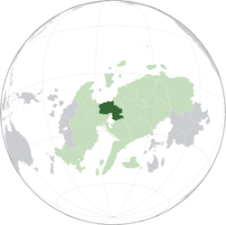
 Ivelboria (dark green) shown within the Veropan Union (light green) | |
| Capital and | Djurma |
| Official languages |
|
| Demonym(s) | Ivelborian |
| Legislature | Parliament of Ivelboria |
| Area | |
• | 547,912 km2 (211,550 sq mi) (52nd) |
| Population | |
• 2024 estimate | 41,054,000 (46th) |
• Density | 74.93/km2 (194.1/sq mi) |
| Gini (2023) | 29.6 low |
| HDI (2023) | very high |
| Currency | Ivelborian Bourbonne (IVB) |
| Time zone | UTC+13 (Midwestern Veropan Time) |
| Date format | yyyy/mm/dd |
| Driving side | left |
| ISO 3166 code | IB |
| Internet TLD | .ib |
Ivelboria[a], officially the Commonwealth of Ivelboria[b] is a country in midwestern Veropa. It is bordered Ambelviser and Skippia to the west, the Pacific Ocean to the north, Saqlazia and Bonmevia to the east and northeast, Neviersia to the south and southeast, and Manima and the Lake of Baverei to the south. With over 41 million people and a land area covering 542,000 square kilometres, Ivelboria is the second most densely populated country in Veropa. The capital and largest city is Djurma.

