Glossápolis: Difference between revisions
Jump to navigation
Jump to search
(infobox tmj svavis) |
(capital) |
||
| (4 intermediate revisions by the same user not shown) | |||
| Line 2: | Line 2: | ||
{{Infobox country | {{Infobox country | ||
| conventional_long_name = | | conventional_long_name = Teocracia de Glossápolis | ||
| native_name = <!-- See Template:Native_name --> | | native_name = <!-- See Template:Native_name --> | ||
| common_name = | | common_name = Glossápolis | ||
| status = Active/Inactive/Defunct | | status = Active/Inactive/Defunct | ||
| image_flag = Bandeira Glossápolis.png | | image_flag = Bandeira Glossápolis.png | ||
| image_coat = NoCoA.svg | | image_coat = NoCoA.svg | ||
| national_motto = | | national_motto = Um só Senhor, Jesus Cristo, Filho unigênito de Deus | ||
| englishmotto = "This motto is an example" <!-- Use only if the motto parameter is in a language other than English, otherwise, remove completey. --> | | englishmotto = "This motto is an example" <!-- Use only if the motto parameter is in a language other than English, otherwise, remove completey. --> | ||
| national_anthem = "[[National anthem]]" <!-- If an audio file for the anthem exists, add {{subst:Anthem spacer}} [[File:Example anthem file.ogg]] </div>--> | | national_anthem = "[[National anthem]]" <!-- If an audio file for the anthem exists, add {{subst:Anthem spacer}} [[File:Example anthem file.ogg]] </div>--> | ||
| Line 18: | Line 18: | ||
| alt_map2 = <!--alt text for second map--> | | alt_map2 = <!--alt text for second map--> | ||
| map_caption2 = <!--Caption to place below second map--> | | map_caption2 = <!--Caption to place below second map--> | ||
| capital = | | capital = Constantinopla | ||
| largest_city = <!--Name of country/territory's largest city. Use "capital" (without quotation marks) if its the capital.--> | | largest_city = <!--Name of country/territory's largest city. Use "capital" (without quotation marks) if its the capital.--> | ||
| largest_settlement_type = <!--Type of settlement if largest settlement not a city--> | | largest_settlement_type = <!--Type of settlement if largest settlement not a city--> | ||
| Line 80: | Line 80: | ||
| official_website = {{url|http://example.com}} | | official_website = {{url|http://example.com}} | ||
}} | }} | ||
<!-- Do not add an empty line after between the infobox and the introductory paragraph.-->Glossápolis (em [https://pt.wikipedia.org/wiki/L%C3%ADngua_grega grego]: Γλωσσάπολη; [https://pt.wikipedia.org/wiki/Romaniza%C3%A7%C3%A3o_(lingu%C3%ADstica) romaniz]: ''Glossápoli)'' oficialmente '''Teocracia de Glossápolis''' (em [https://pt.wikipedia.org/wiki/L%C3%ADngua_grega grego]: Θεοκρατία Γλωσσάπολης; [https://pt.wikipedia.org/wiki/Romaniza%C3%A7%C3%A3o_(lingu%C3%ADstica) romaniz]: ''Theokratía Glossápolis'') é um país localizado no [https://pt.wikipedia.org/wiki/Europa_meridional sul da Europa], a população de Glossápolis é estimada em 22 milhões de habitantes. A capital de Glossápolis é a cidade de [https://pt.wikipedia.org/wiki/Constantinopla Constantinopla] | |||
Glossápolis (em [https://pt.wikipedia.org/wiki/L%C3%ADngua_grega grego]: Γλωσσάπολη; [https://pt.wikipedia.org/wiki/Romaniza%C3%A7%C3%A3o_(lingu%C3%ADstica) romaniz]: ''Glossápoli)'' oficialmente '''Teocracia de Glossápolis''' (em [https://pt.wikipedia.org/wiki/L%C3%ADngua_grega grego]: Θεοκρατία Γλωσσάπολης; [https://pt.wikipedia.org/wiki/Romaniza%C3%A7%C3%A3o_(lingu%C3%ADstica) romaniz]: ''Theokratía Glossápolis'') é um país localizado no [https://pt.wikipedia.org/wiki/Europa_meridional sul da Europa], a população de Glossápolis é estimada em 22 milhões de habitantes. A capital de Glossápolis é a cidade de [https://pt.wikipedia.org/wiki/Constantinopla Constantinopla] | |||
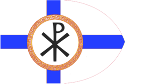
[[File:Bandeira Glossápolis.png|thumb|Bandeira de Glossápolis]] | [[File:Bandeira Glossápolis.png|thumb|Bandeira de Glossápolis]] | ||
O país está estrategicamente localizado no cruzamento entre a [https://pt.wikipedia.org/wiki/Europa Europa], a [https://pt.wikipedia.org/wiki/%C3%81sia Ásia], o [https://pt.wikipedia.org/wiki/M%C3%A9dio_Oriente Oriente Médio] e a [https://pt.wikipedia.org/wiki/%C3%81frica África]. Tem fronteiras terrestres com a [https://pt.wikipedia.org/wiki/Alb%C3%A2nia Albânia] a noroeste, com a [https://pt.wikipedia.org/wiki/S%C3%A9rvia Sérvia] e a [https://pt.wikipedia.org/wiki/Bulg%C3%A1ria Bulgária] ao norte e com a [https://pt.wikipedia.org/wiki/Turquia Turquia] no nordeste. Oitenta por cento do país é composto por montanhas, das quais o [https://pt.wikipedia.org/wiki/Monte_Olimpo Monte Olimpo] é a mais elevada, a 2 917 m de altitude. | O país está estrategicamente localizado no cruzamento entre a [https://pt.wikipedia.org/wiki/Europa Europa], a [https://pt.wikipedia.org/wiki/%C3%81sia Ásia], o [https://pt.wikipedia.org/wiki/M%C3%A9dio_Oriente Oriente Médio] e a [https://pt.wikipedia.org/wiki/%C3%81frica África]. Tem fronteiras terrestres com a [https://pt.wikipedia.org/wiki/Alb%C3%A2nia Albânia] a noroeste, com a [https://pt.wikipedia.org/wiki/S%C3%A9rvia Sérvia] e a [https://pt.wikipedia.org/wiki/Bulg%C3%A1ria Bulgária] ao norte e com a [https://pt.wikipedia.org/wiki/Turquia Turquia] no nordeste. Oitenta por cento do país é composto por montanhas, das quais o [https://pt.wikipedia.org/wiki/Monte_Olimpo Monte Olimpo] é a mais elevada, a 2 917 m de altitude. | ||
Latest revision as of 23:15, 26 September 2024
Teocracia de Glossápolis | |
|---|---|
Coat of arms
| |
| Motto: Um só Senhor, Jesus Cristo, Filho unigênito de Deus "This motto is an example" | |
| Anthem: "National anthem" | |
| Territories of Example Territories of Example | |
| Status | Active/Inactive/Defunct |
| Location | Fakeville, United States |
| Capital | Constantinopla |
| Ethnic groups (2020) |
|
| Religion (2020) |
|
| Demonym(s) | Examplian |
| Government | Federal presidential republic |
• President | Jane AB Citizen |
• Vice President | Jane AB Citizen |
| Legislature | Parliament |
| Independence from the United States | |
• Independence | 20 April 2020 |
• Constitution ratified | 25 April 2020 |
| Membership | 21 |
| Currency | Example dollar |
| Time zone | UTC-2 (XST) |
• Summer (DST) | UTC-1 (XDT) |
| Date format | mm/dd/yyyy |
| Driving side | right |
| Calling code | +1 |
| Internet TLD | .ex |
Website example | |
Glossápolis (em grego: Γλωσσάπολη; romaniz: Glossápoli) oficialmente Teocracia de Glossápolis (em grego: Θεοκρατία Γλωσσάπολης; romaniz: Theokratía Glossápolis) é um país localizado no sul da Europa, a população de Glossápolis é estimada em 22 milhões de habitantes. A capital de Glossápolis é a cidade de Constantinopla
O país está estrategicamente localizado no cruzamento entre a Europa, a Ásia, o Oriente Médio e a África. Tem fronteiras terrestres com a Albânia a noroeste, com a Sérvia e a Bulgária ao norte e com a Turquia no nordeste. Oitenta por cento do país é composto por montanhas, das quais o Monte Olimpo é a mais elevada, a 2 917 m de altitude.

