User:Aurrica/Sandbox: Difference between revisions

Jump to navigation Jump to search
No edit summary
No edit summary
 
(19 intermediate revisions by the same user not shown)
Line 1: Line 1:
{{WIP}}
{{Infobox country
|conventional_long_name =  Consulate of Flarmen
|native_name =              Counsulåt d'Flarmiéne
|common_name =              Flarmen
|image_flag =              Flag of Flarmen.png
|image_coat =              CoA of Aurrica.png
|symbol_type =              Coat of arms
|national_motto =          Libarté i counfidenz<br><small>''Freedom and confidence''</small>
|national_anthem =          ''[[A Orlinoize̊]]<br><small>''The Orlinoise''</small>
|image_map =               
|map_caption =              Map of Flarmen
|image_map2 =             
|map_caption2 =           
|capital =                  [[Orlins]]
|largest_city =            capital
|official_languages =      [[Flarmish language|Flarmish]]
|regional_languages =      some
|demonym =                  Flarmish
|government_type =          {{wp|unitary republic|Unitary}} {{wp|multi-party system|multi-party}} {{wp|parliamentary system|parliamentary}} {{wp|republic}}
|leader_title1 =            [[Consuls of Flarmen|Consuls]]
|leader_name1 =            [[Octave II, Consul of Flarmen|Octave II]]<br>[[Jehonne, Consul of Flarmen|Jehonne]]
|leader_title2 =            [[Captain-Regent of Flarmen|Captain-Regent]]
|leader_name2 =            [[Anne̊ Berthovin]] ([[Liberal Conservative Party (Flarmen)|LC]])
|legislature =              [[Curia (Flarmen)|Curia]]
|upper_house =              [[Senate (Flarmen)|Senate]]
|lower_house =              [[Ecclesia (Flarmen)|Ecclesia]]
|sovereignty_type =        '''[[History of Flarmen]]'''
|established_event1 =      event
|established_date1 =        XXXX
|established_event2 =      [[Act of Association (Flarmen)|Act of Association]]
|established_date2 =        12 November 1701
|area_km2 =               
|area_sq_mi =             
|percent_water =           
|population_estimate =     
|population_estimate_year =
|population_census =        48,870,325
|population_census_year =  2018
|population_density_km2 =  105
|population_density_sq_mi =
|GDP_PPP =                 
|GDP_PPP_year =           
|GDP_PPP_per_capita =     
|GDP_nominal =             
|GDP_nominal_year =       
|GDP_nominal_per_capita = 
|Gini =                   
|Gini_change =             
|Gini_year =               
|HDI_year =               
|HDI =                     
|HDI_change =             
|currency =                [[Flarmish sol]] (₴)
|currency_code =            FLA
|utc_offset =             
|date_format =              dd/mm/yyyy ({{wp|Common Era|CE}})
|drives_on =                {{wp|right- and left-hand traffic|Right}}
|cctld =                    [[.fl]]
|iso3166code =              FL
|calling_code =            +52
}}
'''Flarmen''' ([[Flarmish language|Flamrish]]: '''Flarmiéne'''), known formally as the '''Consulate of Flarmen''' ([[Flarmish language|Flamrish]]: '''Counsulåt d'Flarmiéne'''), is a country in [[Midgard]]. It is bordered by [[Suavia]] to the north, [[Orlav]] and [[Ruvia]] to the east, [[Lecia]] and [[Caria]] to the southeast, [[Learis]] and [[Kalve]] to the southwest, and [[East Engatia]] to the west.
Flarmen is a {{wp|unitary republic|unitary}} {{wp|multi-party system|multi-party}} {{wp|parliamentary system|parliamentary}} {{wp|republic}} with its capital in [[Orlins]]. It is ruled by two [[Consul of Flarmen|consuls]] elected for life by the [[Senate (Flarmen)|Senate]], though in modern times they tend to hold a more ceremonial role, most of the political power being in the hands of the [[Captain-Regent of Flarmen|Captain-Regent]] and their government. This political system is practically unchanged since 1701, though revisions occured in 1785, 1920 and 2001.
Historically, most of current-day Flarmen was made of smaller, independent, often warring states. Overtime, the [[Grand-Consulate of Orlins]], becoming the richest and most powerful due to extensive trading policies, gradually gained influence and progressively integrated the smaller states, spreading its political system, religion and dialect. Flarmen, in its current form, was eventually founded on 12 November 1701, with the signature of the [[Act of Association (Flarmen)|Act of Association]].
== Geography ==
=== city names i'm potentially gonna use ===
{| class="wikitable"
!Map!!Name and flag!!Administrative centre!!Code
|-
|-
! City !! Population
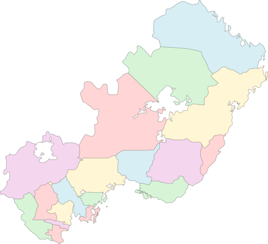
| rowspan="21" |<center>{{Hullivia labelled map}}</center>
! colspan="3" |[[Administrative divisions of Hullivia|Communes of Hullivia]]
|-
|-
| '''[[Orlins]]''' || '''XXX'''
|[[File:Flag_of_Albe.png|22px]] [[Albe (Hullivia)|Albe]]||[[Gladbach]]||AL
|-
|-
| [[Ponnouvia]] || XXX
|[[File:Flag_of_Ebengäu.png|22px]] [[Ebengäu]]||[[Heidelstrand]]||EB
|-
|-
| [[Toire]] || XXX
|[[File:Flag_of_Holzküste.png|22px]] [[Holzküste]]||[[Otthafen]]||HK
|-
|-
| [[Rothambourc]] || XXX
|[[File:Flag_of_Jadeküste.png|22px]] [[Jadeküste]]||[[Neu-Kolreuth]]||JK
|-
|-
| [[Spéirmound]] || XXX
|[[File:Flag_of_Johannsland.png|22px]] [[Johannsland]]||[[Plattau]]||JO
|-
|-
| [[Modernenz]] || XXX
|[[File:Flag_of_Landshut.png|22px]] [[Landshut]]||[[Pôlterswil]]||LA
|-
|-
| [[Thoiz]] || XXX
|[[File:Flag_of_Leyenland.png|22px]] [[Leyenland]]||[[Fürstenmeyer]]||LY
|-
|-
| [[Samur]] || XXX
|[[File:Flag_of_Marani.png|22px]] [[Marani]]||[[Uheitawa]]||MA
|-
|-
| [[Huberne]] || XXX
|[[File:Flag_of_Mittelhüllivien.png|22px]] [[Central Hullivia]]||[[Ludwigsdorf]]||MH
|-
|-
| [[Botzaris]] || XXX
|[[File:Flag_of_Neueböden.png|22px]] [[Neueböden]]||[[Warmwasser]]||NB
|-
|-
| [[Hunor]] || XXX
|[[File:Flag_of_Neu-Elbenweis.png|22px]] [[New Elbenweis]]||[[Antipolis]]||NE
|-
|-
| [[Payor]] || XXX
|[[File:Flag_of_Osternburg.png|22px]] [[Osternburg Commune|Osternburg]]||[[Osternburg]]||OB
|-
|-
| [[Dizor]] || XXX
|[[File:Flag_of_Sparten.png|22px]] [[Sparten]]||[[Horvathstadt]]||SP
|-
|-
| [[Loizo]] || XXX
|[[File:Flag_of_Gemeinde_Süd.png|22px]] [[South Commune (Hullivia)|South]]||[[Rio Verde]]||SD
|-
|-
| [[Vandœuvre-sua-Gråve]] || XXX
|[[File:Flag_of_Taguaschu.png|22px]] [[Taguaschu]]||[[Pytaiva]]||TA
|-
|-
| [[Rurbourc]] || XXX
|[[File:Flag_of_Tiaraju.png|22px]] [[Tiaraju Commune|Tiaraju]]||[[Tiarajustadt]]||TI
|-
|-
| [[Aume̊lo]] || XXX
|[[File:Flag_of_Trockengras.png|22px]] [[Trockengras]]||[[Rudolfsburg]]||TG
|-
|-
| [[Siérz]] || XXX
|[[File:Flag_of_Zuckerland.png|22px]] [[Zuckerland]]||[[Robertsau]]||ZU
|-
|-
| [[Alsoum]] || XXX
! colspan="3" |[[Administrative divisions of Hullivia|Territories with special status]]
|-
|-
| [[Santia]] || XXX
|[[File:Flag of the Horvath District.png|22px]] [[Horvath District]]||[[Die Friede]]||HD
|-
|-
| [[Gonon]] || XXX
|-
| [[Rével]] || XXX
|-
| [[Delmound]] || XXX
|-
| [[Eulos]] || XXX
|-
| [[Dolonya]] || XXX
|-
| [[Busancourt]] || XXX
|-
| [[Olange]] || XXX
|-
| [[Laxoum]] || XXX
|-
| [[Chate̊linau]] || XXX
|-
| [[Chataumoulin]] || XXX
|}
|}

Latest revision as of 00:38, 8 February 2021