Danvaut: Difference between revisions
Jump to navigation
Jump to search
(Created page with "'''DANVOUT''' Danvout is a marvelous province known for it's quiet countrysides and big cities it plays a major role in the Republic's Politics Cities Population: 1. Whitokot...") |
No edit summary |
||
| (One intermediate revision by the same user not shown) | |||
| Line 1: | Line 1: | ||
{{wip}} | |||
{{Infobox settlement | |||
|name = The Province of Danvaut | |||
|native_name = Ģoobíá čeçć<!-- Settlement name in local language(s), if different from the English name --> | |||
|native_name_lang = <!-- ISO 639-1 code e.g. "fr" for French. If more than one, use {{lang}} instead --> | |||
|settlement_type = Province | |||
|image_skyline = | |||
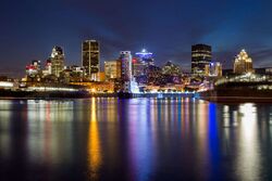
[[File:Skyline of Whitokotoks.jpg|250x250px]] | |||
|imagesize = | |||
|image_alt = | |||
|image_caption = | |||
|image_flag = | |||
[[File:Flag of Danvaut.png|140x140px]] | |||
|flag_alt = | |||
|image_seal = | |||
|seal_alt = | |||
|image_shield = | |||
|shield_alt = | |||
|etymology = | |||
|nickname = | |||
|motto = | |||
|image_map = | |||
|map_alt = | |||
|map_caption = | |||
|pushpin_map = | |||
|pushpin_map_alt = | |||
|pushpin_map_caption = | |||
|pushpin_mapsize = | |||
|pushpin_label_position = | |||
|coordinates = <!-- {{coord|latitude|longitude|type:city|display=inline,title}} --> | |||
|coor_pinpoint = | |||
|coordinates_footnotes = | |||
|subdivision_type = Country | |||
|subdivision_name = [[Tomikals]] | |||
|subdivision_type1 = Capital | |||
|subdivision_name1 = [[Bay of Namib]] | |||
|subdivision_type2 = | |||
|subdivision_name2 = | |||
|subdivision_type3 = | |||
|subdivision_name3 = | |||
|established_title = Frobisher Plains | |||
|established_date = 1575 | |||
|founder = [[Martin Frobisher]] | |||
|seat_type = | |||
|seat = | |||
|government_footnotes = | |||
|government_type = | |||
|governing_body = Legislative Assembly of Danvaut | |||
|leader_party = | |||
|leader_title = Premier of the Province of Danvaut | |||
|leader_name = Henry Dameon | |||
|leader_title1 = | |||
|leader_name1 = | |||
|leader_title2 = | |||
|leader_name2 = | |||
|leader_title3 = | |||
|leader_name3 = | |||
|leader_title4 = | |||
|leader_name4 = | |||
|unit_pref = Metric | |||
<!-- ALL fields with measurements have automatic unit conversion --> | |||
<!-- for references: use <ref> tags --> | |||
|area_footnotes = | |||
|area_urban_footnotes = <!-- <ref> </ref> --> | |||
|area_rural_footnotes = <!-- <ref> </ref> --> | |||
|area_metro_footnotes = <!-- <ref> </ref> --> | |||
|area_note = | |||
|area_water_percent = | |||
|area_rank = | |||
|area_blank1_title = | |||
|area_blank2_title = | |||
<!-- square kilometers --> | |||
|area_total_km2 = 504,144 | |||
|area_land_km2 = 326,760 | |||
|area_water_km2 = 177,384 | |||
|area_urban_km2 = 40,456 | |||
|area_rural_km2 = 286,304 | |||
|area_metro_km2 = | |||
|area_blank1_km2 = | |||
|area_blank2_km2 = | |||
<!-- hectares --> | |||
|area_total_ha = | |||
|area_land_ha = | |||
|area_water_ha = | |||
|area_urban_ha = | |||
|area_rural_ha = | |||
|area_metro_ha = | |||
|area_blank1_ha = | |||
|area_blank2_ha = | |||
|length_km = | |||
|width_km = | |||
|dimensions_footnotes = | |||
|elevation_footnotes = | |||
|elevation_m = | |||
|population_footnotes = | |||
|population_as_of = | |||
|population_total = 10,526,789 | |||
|population_density_km2 = auto | |||
|population_note = | |||
|population_demonym = | |||
|timezone1 = {{wpl|UTC-1:00}} | |||
|utc_offset1 = | |||
|timezone1_DST = | |||
|utc_offset1_DST = | |||
|postal_code_type = | |||
|postal_code = | |||
|area_code_type = | |||
|area_code = | |||
|area_codes = <!-- for multiple area codes --> | |||
|iso_code = | |||
|website = <!-- {{URL|example.com}} --> | |||
|module = | |||
|footnotes = | |||
}} | |||
==History== | |||
Latest revision as of 21:53, 9 December 2023
This article is incomplete because it is pending further input from participants, or it is a work-in-progress by one author. Please comment on this article's talk page to share your input, comments and questions. Note: To contribute to this article, you may need to seek help from the author(s) of this page. |
The Province of Danvaut
Ģoobíá čeçć | |
|---|---|
Province | |
 | |
| Country | Tomikals |
| Capital | Bay of Namib |
| Frobisher Plains | 1575 |
| Founded by | Martin Frobisher |
| Government | |
| • Body | Legislative Assembly of Danvaut |
| • Premier of the Province of Danvaut | Henry Dameon |
| Area | |
| • Province | 504,144 km2 (194,651 sq mi) |
| • Land | 326,760 km2 (126,160 sq mi) |
| • Water | 177,384 km2 (68,488 sq mi) |
| • Urban | 40,456 km2 (15,620 sq mi) |
| • Rural | 286,304 km2 (110,543 sq mi) |
| Population | |
| • Province | 10,526,789 |
| • Density | 21/km2 (54/sq mi) |
| Time zone | UTC-1:00 |
