Kingdom of Le Monke: Difference between revisions
No edit summary |
|||
| (51 intermediate revisions by the same user not shown) | |||
| Line 1: | Line 1: | ||
Verified member of the [[Nations of Saint Joan of Arc (School Community)]] | Verified member of the [[Nations of Saint Joan of Arc (School Community)]] | ||
{{Infobox country | {{Infobox country | ||
|conventional_long_name = Kingdom Of Le Monke | |conventional_long_name = Kingdom Of Le Monke | ||
|common_name = Monke | |common_name = Monke | ||
|image_flag = | |image_flag = Monke.jpg | ||
|alt_flag = Vertical tricolor (green, red, yellow) with a five-pointed gold star in the center of the red. | |alt_flag = Vertical tricolor (green, red, yellow) with a five-pointed gold star in the center of the red. | ||
|image_map = | |image_map = [[File:Wowa.png|frameless]] [[File:Map12.png|thumb]] Location , Political and Physical Map | ||
|alt_map = | |alt_map = Political Map and Physical Map | ||
|national_motto = | |national_motto = | ||
|national_anthem = | |national_anthem = | ||
|official_languages = {{hlist |[[French language|French]] |[[English language|English]]}} | |official_languages = {{hlist |[[French language|French]] |[[English language|English]] | [[Spanish language|Spanish]] }} | ||
|demonym = Monkian | |demonym = Monkian | ||
|ethnic_groups = | |ethnic_groups = | ||
{{unbulleted list | {{unbulleted list | ||
| | | 51% Monkians | ||
| 19% | | 19% Europeans | ||
| 7% Eastern Nigritic | | 7% Eastern Nigritic | ||
| 13% other African | | 13% other African | ||
| < | | <10% non-African | ||
}} | }} | ||
|capital = | |capital = Monke Temple | ||
|largest_city = Chaian | |||
|largest_city = | |government_type = [[Monarchy]] | ||
|government_type = [[ | |leader_title1 = | ||
|leader_title1 = | |leader_name1 = | ||
|leader_name1 = | |leader_title2 = | ||
|leader_title2 = | |leader_name2 = | ||
|leader_name2 = | |legislature = | ||
|legislature = | |||
|area_rank = 54th <!--Demographic Yearbook 1.--> | |area_rank = 54th <!--Demographic Yearbook 1.--> | ||
|area_km2 = 475,442 | |area_km2 = 475,442 | ||
|area_sq_mi = 183,568 <!--Do not remove per [[WP:MOSNUM]]--> | |area_sq_mi = 183,568 <!--Do not remove per [[WP:MOSNUM]]--> | ||
|percent_water = 1.3 <!--CIA World Factbook--> | |percent_water = 1.3 <!--CIA World Factbook--> | ||
|population_estimate = | |population_estimate = 40,000,000 | ||
|population_estimate_year = July 2012 | |population_estimate_year = July 2012 | ||
|population_census = | |population_census = 37,463,836 | ||
|population_census_year = | |population_census_year = 2017 | ||
|sovereignty_type = Independence {{nobold|from [[France]]}} | |sovereignty_type = Independence {{nobold|from [[France]]}} | ||
|established_event1 = Declared | |established_event1 = Declared | ||
|established_date1 = 1 January 1960 | |established_date1 = 1 January 1960 | ||
}} | }} | ||
The Kingdom of | =Kingdom Of Le Monke= | ||
The Kingdom of Le Monke is an island southwest of Mexico. It is a semi-constitutional monarchy, which is controlled from the nation's capital; The Temple of Le Monke. The Island of Monke has a very tropical climate. This means that there is very little to no droughts. This makes the kingdom of Le Monke a very good ally. It is able to supply many resources to its trade partners and military allies. The citizens of Monke can create surplus crops and fruits. The market is dominated by the crop and the fish market. The average income | |||
The | =Etymology= | ||
The name derives from the way it was found. The way the Island of Monke was found was that of an early explorer. He and his monkey named Le Monke found the island after years of exploring. They found a river that led them to the center of the island. At the center they found an area surrounded by mountains which is now the capital of the island. Over years as the population grew bigger they named the island after the explorer’s monkey. Now the island can produce many crops per year. This has gained the Kingdom of Le Monke many alliances . | |||
The Kingdom | =Alliances= | ||
The Kingdom of Le Monke has a military alliance with the Republic of Shrek. It also is trade partners with The Empire of Taco and The Republic of Cruz. The Kingdom of Le Monke is able to supply its allies with great quantities of crops and food. While the Kingdom of Le Monke can supply the Republic of Shrek with food, it can supply military support. The Kingdom of Le Monke supplies the Empire of Taco with crops and fruits and the Empire of Taco gives tacos to the people of Monke. | |||
=Precolonization= | |||
Before the island was colonized by the explorer and his crew, there were many native tribes there. The native tribes were dominant in the early years. Over time the non native people became dominant but the native people weren’t driven out and were friendly with the non natives. Most of the traditions now are based on the native people and their kindness. Native and non native people live in harmony on the island of Monke. | |||
=History= | |||
The Kingdom of Le Monke was discovered only because of the explorer; Billy the Compass, searching for gold and fame. It was discovered in the 1600s but was only declared itself in 1960. After not finding anything on the island they were about to leave and head back to their home land they were pulled into a river that led them to the center of the island. There they found an area surrounded by mountains. The area they had found had many resources. In the mountains there was gold and silver. And the soil there was much richer than the other parts of the island. This area became the capital and the main attraction of the island. | |||
=Political and Physical Map= | |||
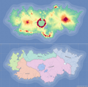
The island is separated into 6 states. These states are Redc, Alver, Chaian, Margia, Matil and Lopoty. The largest being Chaian and the main state being Lopoty. The main crop producer state is Chaian. And the main fish market being in Redc. The island is mostly populated by mountains and plains. Each state has a representative and the representative of Lopoty is the King or Queen. Margia and Matil are the main meat producers from animals flocking there for winter and other seasons. | |||
Latest revision as of 13:01, 14 October 2020
Verified member of the Nations of Saint Joan of Arc (School Community)
Kingdom Of Le Monke | |
|---|---|
|
Flag | |
 Location , Political and Physical Map Location , Political and Physical Map | |
| Capital | Monke Temple |
| Largest city | Chaian |
| Official languages | |
| Ethnic groups |
|
| Demonym(s) | Monkian |
| Government | Monarchy |
| Independence from France | |
• Declared | 1 January 1960 |
| Area | |
• Total | 475,442 km2 (183,569 sq mi) (54th) |
• Water (%) | 1.3 |
| Population | |
• July 2012 estimate | 40,000,000 |
• 2017 census | 37,463,836 |
Kingdom Of Le Monke
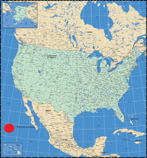
The Kingdom of Le Monke is an island southwest of Mexico. It is a semi-constitutional monarchy, which is controlled from the nation's capital; The Temple of Le Monke. The Island of Monke has a very tropical climate. This means that there is very little to no droughts. This makes the kingdom of Le Monke a very good ally. It is able to supply many resources to its trade partners and military allies. The citizens of Monke can create surplus crops and fruits. The market is dominated by the crop and the fish market. The average income
Etymology
The name derives from the way it was found. The way the Island of Monke was found was that of an early explorer. He and his monkey named Le Monke found the island after years of exploring. They found a river that led them to the center of the island. At the center they found an area surrounded by mountains which is now the capital of the island. Over years as the population grew bigger they named the island after the explorer’s monkey. Now the island can produce many crops per year. This has gained the Kingdom of Le Monke many alliances .
Alliances
The Kingdom of Le Monke has a military alliance with the Republic of Shrek. It also is trade partners with The Empire of Taco and The Republic of Cruz. The Kingdom of Le Monke is able to supply its allies with great quantities of crops and food. While the Kingdom of Le Monke can supply the Republic of Shrek with food, it can supply military support. The Kingdom of Le Monke supplies the Empire of Taco with crops and fruits and the Empire of Taco gives tacos to the people of Monke.
Precolonization
Before the island was colonized by the explorer and his crew, there were many native tribes there. The native tribes were dominant in the early years. Over time the non native people became dominant but the native people weren’t driven out and were friendly with the non natives. Most of the traditions now are based on the native people and their kindness. Native and non native people live in harmony on the island of Monke.
History
The Kingdom of Le Monke was discovered only because of the explorer; Billy the Compass, searching for gold and fame. It was discovered in the 1600s but was only declared itself in 1960. After not finding anything on the island they were about to leave and head back to their home land they were pulled into a river that led them to the center of the island. There they found an area surrounded by mountains. The area they had found had many resources. In the mountains there was gold and silver. And the soil there was much richer than the other parts of the island. This area became the capital and the main attraction of the island.
Political and Physical Map
The island is separated into 6 states. These states are Redc, Alver, Chaian, Margia, Matil and Lopoty. The largest being Chaian and the main state being Lopoty. The main crop producer state is Chaian. And the main fish market being in Redc. The island is mostly populated by mountains and plains. Each state has a representative and the representative of Lopoty is the King or Queen. Margia and Matil are the main meat producers from animals flocking there for winter and other seasons.

