Antachia City: Difference between revisions
Jump to navigation
Jump to search
(Created page with "{{Infobox settlement <!-- See Template:Infobox settlement for additional fields and descriptions --> | name = Antachia City | official_name = ''City of An...") |
No edit summary |
||
| (One intermediate revision by the same user not shown) | |||
| Line 1: | Line 1: | ||
{{wip}} | |||
{{Infobox settlement | {{Infobox settlement | ||
|name = Antachia City | |||
| name | |native_name = Ethria | ||
| | |native_name_lang = <!-- ISO 639-1 code e.g. "fr" for French. If more than one, use {{lang}} instead --> | ||
| | |settlement_type = [[Capital city]] and ''[[commune]]'' | ||
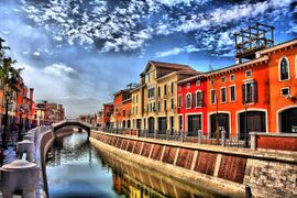
| settlement_type | |image_skyline = [[File:SkylineAntachiaCity.jpg|270px]] | ||
| image_skyline | |imagesize = | ||
| | |image_alt = | ||
| | |image_caption = Skyline of Antachia City | ||
| | |image_flag = [[File:AntachiaCityFlag.PNG|270px]] | ||
| | |flag_alt = | ||
|image_seal = | |||
|seal_alt = | |||
| etymology | |image_shield = | ||
| | |shield_alt = | ||
| | |etymology = | ||
| | |nickname = | ||
|motto = | |||
| | |image_map = | ||
| map_caption | |map_alt = | ||
| pushpin_map = | |map_caption = | ||
| pushpin_map_caption = | |pushpin_map = | ||
| | |pushpin_map_alt = | ||
| coordinates | |pushpin_map_caption = | ||
| coor_pinpoint | |pushpin_label_position = | ||
|coordinates = <!-- {{coord|latitude|longitude|type:city|display=inline,title}} --> | |||
| subdivision_type | |coor_pinpoint = | ||
| subdivision_name | |coordinates_footnotes = | ||
| subdivision_type2 | |subdivision_type = Country | ||
| | |subdivision_name = | ||
| | |subdivision_type1 = | ||
| | |subdivision_name1 = | ||
|subdivision_type2 = | |||
|subdivision_name2 = | |||
| government_footnotes= | |subdivision_type3 = | ||
| government_type | |subdivision_name3 = | ||
| | |established_title = | ||
| | |established_date = | ||
| leader_title1 | |founder = | ||
| | |seat_type = | ||
| | |seat = | ||
| unit_pref | |government_footnotes = | ||
<!-- | |government_type = | ||
| | |governing_body = | ||
| | |leader_party = | ||
| | |leader_title = | ||
| | |leader_name = | ||
| | |leader_title1 = | ||
<!-- | |leader_name1 = | ||
| | |leader_title2 = | ||
| | |leader_name2 = | ||
| | |leader_title3 = | ||
| | |leader_name3 = | ||
| | |leader_title4 = | ||
| | |leader_name4 = | ||
| | |unit_pref = Metric | ||
| | <!-- ALL fields with measurements have automatic unit conversion --> | ||
| | <!-- for references: use <ref> tags --> | ||
| | |area_footnotes = | ||
|area_urban_footnotes = <!-- <ref> </ref> --> | |||
| | |area_rural_footnotes = <!-- <ref> </ref> --> | ||
| | |area_metro_footnotes = <!-- <ref> </ref> --> | ||
|area_magnitude = <!-- <ref> </ref> --> | |||
| | |area_note = | ||
| | |area_water_percent = | ||
| | |area_rank = | ||
| | |area_blank1_title = | ||
| | |area_blank2_title = | ||
| | <!-- square kilometers --> | ||
|area_total_km2 = | |||
| | |area_land_km2 = | ||
| | |area_water_km2 = | ||
| | |area_urban_km2 = | ||
|area_rural_km2 = | |||
| | |area_metro_km2 = | ||
| | |area_blank1_km2 = | ||
|area_blank2_km2 = | |||
| | <!-- hectares --> | ||
|area_total_ha = | |||
|area_land_ha = | |||
|area_water_ha = | |||
|area_urban_ha = | |||
|area_rural_ha = | |||
|area_metro_ha = | |||
|area_blank1_ha = | |||
|area_blank2_ha = | |||
|length_km = | |||
|width_km = | |||
|dimensions_footnotes = | |||
|elevation_footnotes = | |||
|elevation_m = | |||
|population_footnotes = | |||
|population_as_of = | |||
|population_total = | |||
|population_density_km2 = auto | |||
|population_note = | |||
|population_demonym = | |||
|timezone1 = | |||
|utc_offset1 = | |||
|timezone1_DST = | |||
|utc_offset1_DST = | |||
|postal_code_type = | |||
|postal_code = | |||
|area_code_type = | |||
|area_code = | |||
|area_codes = 200, 211, 221, 222, 230, 232, 233, 235, 237, 238, 241, 243, 244, 245, 247, 255, 257, 258, 259, 261, 263 | |||
|iso_code = | |||
|website = <!-- {{URL|example.com}} --> | |||
|module = | |||
|footnotes = | |||
}} | }} | ||
Latest revision as of 11:01, 29 January 2021
This article is incomplete because it is pending further input from participants, or it is a work-in-progress by one author. Please comment on this article's talk page to share your input, comments and questions. Note: To contribute to this article, you may need to seek help from the author(s) of this page. |
Antachia City
Ethria | |
|---|---|
Capital city and commune | |
 Skyline of Antachia City | |
| Area codes | 200, 211, 221, 222, 230, 232, 233, 235, 237, 238, 241, 243, 244, 245, 247, 255, 257, 258, 259, 261, 263 |
