Rouge Kiwein: Difference between revisions
No edit summary |
|||
| (3 intermediate revisions by the same user not shown) | |||
| Line 21: | Line 21: | ||
|national_anthem = "La Brabançonne" | |national_anthem = "La Brabançonne" | ||
|image_map = | |image_map = | ||
[[File: | [[File:Rouge2.jpg|frameless|center]] | ||
|capital = absent (de jure) | |capital = absent (de jure) | ||
<br>[[Beron]] (de facto) | <br>[[Beron]] (de facto) | ||
| Line 85: | Line 85: | ||
In the north and southeast, Rouge Kiwein borders the United Kingdom of [[Orange-Bourgogne]], in the west with the Empire of [[Labyrnna]], in the east with the [[German Democratic Republic]], in the southeast with the Confederacy of [[Badeuria]]. | In the north and southeast, Rouge Kiwein borders the United Kingdom of [[Orange-Bourgogne]], in the west with the Empire of [[Labyrnna]], in the east with the [[German Democratic Republic]], in the southeast with the Confederacy of [[Badeuria]]. | ||
According to the state structure, this is a confederation, it consists of 15 Cantons:. The form of government is federal {{wp|directorial republic}}. Each year, one of the seven members of the Federal Council becomes President and the other Vice President. For 2021, the President is [[Matthias Veenstra]], the Vice President is [[Fabien Rousseau]]. | According to the state structure, this is a confederation, it consists of 15 Cantons: West Flanders, East Flanders, Terneuzen, Antwerp, Brabant, Limburg, Hainaut, Namur, Chimai, Liège, Luxembourg, Dinant, Bouillon, Bastenaken, Eupen. The form of government is federal {{wp|directorial republic}}. Each year, one of the seven members of the Federal Council becomes President and the other Vice President. For 2021, the President is [[Matthias Veenstra]], the Vice President is [[Fabien Rousseau]]. | ||
In Rouge Kivein, three languages are officially recognized - Dutch, French and German. They have equal rights. | In Rouge Kivein, three languages are officially recognized - Dutch, French and German. They have equal rights. | ||
| Line 105: | Line 105: | ||
==Administrative division== | ==Administrative division== | ||
{| class="wikitable | {| class="wikitable" style="text-align:left; font-size:75%;" | ||
|- | |- | ||
! Map !! Canton !! Dutch name !! French name !! German name !! Capital !! Population !! Area | ! Map !! Canton !! Dutch name !! French name !! German name !! Capital !! Population !! Area | ||
|- | |- | ||
|rowspan=16|{{Rouge Kiwein labled map}} | |rowspan=16|{{Rouge Kiwein labled map}} | ||
| [[West Flanders]] || | | [[West Flanders]] || West-Vlaanderen || Flandre occidentale || Westflandern || [[Brugge]] || 1,200,945 || 3144 | ||
|- | |- | ||
| [[East Flanders]] || | | [[East Flanders]] || Oost-Vlaanderen || Flandre orientale || Ostflandern || [[Gent]] || 1,172,457 || 2982 | ||
|- | |- | ||
| [[Terneuzen]] || | | [[Terneuzen]] || Terneuzen || Ternossen || Terneuzen || [[Terneuzen]] || 978,366 || 2092 | ||
|- | |- | ||
| [[Antwerp]] || | | [[Antwerp]] || Antwerpen || Anvers || Antwerpen || [[Antwerpen]] || 1,710,222 || 2867 | ||
|- | |- | ||
| [[Brabant]] || | | [[Brabant]] || Brabant || Brabant || Brabant || [[Beron]] || 2,523,811 || 3197 | ||
|- | |- | ||
| [[Limburg]] || | | [[Limburg]] || Limburg || Limbourg || Limburg || [[Hasselt]] || 1,005,485 || 2426 | ||
|- | |- | ||
| [[Hainaut]] || | | [[Hainaut]] || Henegouwen || Hainaut || Hennegau || [[Mons]] || 1,226,959 || 2986 | ||
|- | |- | ||
| [[Namur]] || | | [[Namur]] || Namen || Namur || Namen || [[Namur]] || 1,403,436 || 2107 | ||
|- | |- | ||
| [[Chimai]] || | | [[Chimai]] || Chimay || Chimai || Schimen || [[Chimai]] || 799,581 || 1988 | ||
|- | |- | ||
| [[Liège]] || | | [[Liège]] || Luik || Liège || Lüttich || [[Liège]] || 1,870,325 || 3862 | ||
|- | |- | ||
| [[Luxembourg]] || | | [[Luxembourg]] || Lëtzebuerg || Luxembourg || Luxemburg || [[Luxembourg]] || 726,108 || 2586 | ||
|- | |- | ||
| [[Dinant]] || | | [[Dinant]] || Dinant || Dinant || Dinant || [[Biarin]] || 892,443 || 1816 | ||
|- | |- | ||
| [[Bouillon]] || | | [[Bouillon]] || Bulen || Bouillon || Beulen || [[Bouillon]] || 607,557 || 1349 | ||
|- | |- | ||
| [[Bastenaken]] || | | [[Bastenaken]] || Bastenaken || Bastogne || Baaschtnech || [[La Roche-en-Ardenne]] || 743,189 || 1295 | ||
|- | |- | ||
| [[Eupen]] || | | [[Eupen]] || Eupen || Néau || Eupen || [[Neuenburg]] || 378,640 || 1361 | ||
|- | |- | ||
|} | |} | ||
Latest revision as of 11:51, 25 March 2021
The Federal Republic of Rouge Kiwein | |
|---|---|
| Motto: "Liberté, égalité et fraternité" | |
| Anthem: "La Brabançonne" | |
| Capital | absent (de jure)
Beron (de facto) |
| Largest city | Beron |
| Official languages | Dutch, French, German |
| Ethnic groups (2020) | Kiweinians(56%) Rougeans (39%) Dutch (2.7%) Germans (2.2%) Other (0.1%) |
| Demonym(s) | Kiweinists |
| Government | Federal semi-direct democracy under a multi-party assembly-independent directorial republic |
• President for 2021 | Matthias Veenstra |
• Vice President for 2021 | Fabien Rousseau |
| Legislature | Federal Assembly |
| Council of States | |
| National Council | |
| Foundation | |
• Marriage of Duke Kiwein and Duchess of Rougebourg | 1640 |
• Independence | 1833 |
• The abolition of the monarchy | 1944 |
| Area | |
• Total | 36,158 km2 (13,961 sq mi) |
• Water (%) | 6.4 % |
| Population | |
• 2020 estimate | 17,239,524 |
• 2015 census | 16,730,864 |
• Density | 476.8/km2 (1,234.9/sq mi) |
| GDP (PPP) | 2020 estimate |
• Total | 976.7 billion |
• Per capita | 56,655 |
| GDP (nominal) | 2020 estimate |
• Total | 928.1 billion |
• Per capita | 53,836 |
| Gini (2020) | 24.6 low |
| HDI (2020) | 0.960 very high |
| Currency | kiweinian dollar (₭) (KIW) |
| Time zone | UTCSummer (DST) UTC+2 (CEST) (UTC+1 (CET)) |
| Date format | yyyy.mm.dd |
| Driving side | right |
| Calling code | +32 |
| ISO 3166 code | RWN |
| Internet TLD | .rwn |
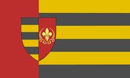
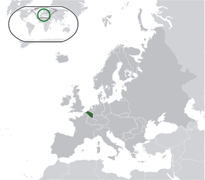
Rouge Kiwein, officially the Federal Republic of Rouge Kiwein is a sovereign state, socially oriented country located in the north-west of Europe. Area - 36,158 km², population - 17,239,524 people. There is no de jure capital, but the de facto capital is the largest city of Beron, in which the Federal Council sits.
In the north and southeast, Rouge Kiwein borders the United Kingdom of Orange-Bourgogne, in the west with the Empire of Labyrnna, in the east with the German Democratic Republic, in the southeast with the Confederacy of Badeuria.
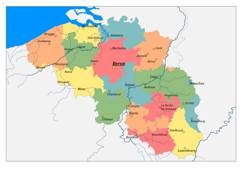
According to the state structure, this is a confederation, it consists of 15 Cantons: West Flanders, East Flanders, Terneuzen, Antwerp, Brabant, Limburg, Hainaut, Namur, Chimai, Liège, Luxembourg, Dinant, Bouillon, Bastenaken, Eupen. The form of government is federal directorial republic. Each year, one of the seven members of the Federal Council becomes President and the other Vice President. For 2021, the President is Matthias Veenstra, the Vice President is Fabien Rousseau.
In Rouge Kivein, three languages are officially recognized - Dutch, French and German. They have equal rights.
Rouge Kivein is a country with a dynamically developing economy. GDP for 2020 was 976.7 billion kiweinian dollars (about 56,655 per capita).
Etymology
History
Geografy
Relief
Climate
Demographics
Religion
Ethnicity
Language
Education
Largest Cities
State structure
Administrative division
| Map | Canton | Dutch name | French name | German name | Capital | Population | Area |
|---|---|---|---|---|---|---|---|
| West Flanders | West-Vlaanderen | Flandre occidentale | Westflandern | Brugge | 1,200,945 | 3144 | |
| East Flanders | Oost-Vlaanderen | Flandre orientale | Ostflandern | Gent | 1,172,457 | 2982 | |
| Terneuzen | Terneuzen | Ternossen | Terneuzen | Terneuzen | 978,366 | 2092 | |
| Antwerp | Antwerpen | Anvers | Antwerpen | Antwerpen | 1,710,222 | 2867 | |
| Brabant | Brabant | Brabant | Brabant | Beron | 2,523,811 | 3197 | |
| Limburg | Limburg | Limbourg | Limburg | Hasselt | 1,005,485 | 2426 | |
| Hainaut | Henegouwen | Hainaut | Hennegau | Mons | 1,226,959 | 2986 | |
| Namur | Namen | Namur | Namen | Namur | 1,403,436 | 2107 | |
| Chimai | Chimay | Chimai | Schimen | Chimai | 799,581 | 1988 | |
| Liège | Luik | Liège | Lüttich | Liège | 1,870,325 | 3862 | |
| Luxembourg | Lëtzebuerg | Luxembourg | Luxemburg | Luxembourg | 726,108 | 2586 | |
| Dinant | Dinant | Dinant | Dinant | Biarin | 892,443 | 1816 | |
| Bouillon | Bulen | Bouillon | Beulen | Bouillon | 607,557 | 1349 | |
| Bastenaken | Bastenaken | Bastogne | Baaschtnech | La Roche-en-Ardenne | 743,189 | 1295 | |
| Eupen | Eupen | Néau | Eupen | Neuenburg | 378,640 | 1361 |


