Kurzhistan: Difference between revisions
| (20 intermediate revisions by the same user not shown) | |||
| Line 78: | Line 78: | ||
===Physical geography=== | ===Physical geography=== | ||
[[File:Topographical map of Kurzhistan.png|200px|thumb|left|Physical Map of Kurzhistan]] | |||
Kurzhistan's geographic landscape is far more complicated than one might assume at first, with most simply dismissing kurzhistan as a land of deserts and sand dunes, For starters, Kurzhistan lies on the central thrismarian highlands, which cover the central regions of thrismari, with its own steppes and desert regions, among which the most iconic are the '''Dehrani-Al-Sahmar Steppes''', which serve as the major pasture grounds for the domesticated cattles of the kurzhi tribals and village folk. | Kurzhistan's geographic landscape is far more complicated than one might assume at first, with most simply dismissing kurzhistan as a land of deserts and sand dunes, For starters, Kurzhistan lies on the central thrismarian highlands, which cover the central regions of thrismari, with its own steppes and desert regions, among which the most iconic are the '''Dehrani-Al-Sahmar Steppes''', which serve as the major pasture grounds for the domesticated cattles of the kurzhi tribals and village folk. | ||
| Line 86: | Line 86: | ||
The '''Adanshar''' River flows from the northern temperate regions, to the kurzat deserts, meeting with the Al-Huati oasis in the process, while a tributary of that river, flows directly towards the sea, giving rise to the steppes in the process. The Adanshar's length streches on to an impressive 425 kms and with a width of around 12.5 metres, its flowing results in the cultivable land necessary for the tribals and the rural people to grow their crops on, thus providing the state with its much needed needs. | The '''Adanshar''' River flows from the northern temperate regions, to the kurzat deserts, meeting with the Al-Huati oasis in the process, while a tributary of that river, flows directly towards the sea, giving rise to the steppes in the process. The Adanshar's length streches on to an impressive 425 kms and with a width of around 12.5 metres, its flowing results in the cultivable land necessary for the tribals and the rural people to grow their crops on, thus providing the state with its much needed needs. | ||
While these serve, as the landscapes of what one would consider as the entirity of kurzhistan, there are massive mountain ranges that cover the western sides of the nation, from the violent winds that rage in that area, and act as an natural barrier against foreign intervention of any sorts. The '''Al-Khadur''' Mountain ranges are the main mountains that cover the region, reaching at an average height of 3000+ metres, these mountains are one of the most rugged mountain ranges in the region, and serve as one of the major tourist attractions in the nation. | |||
The Mountains are home to some of the rare tundra fauna and flora that can be seen only in cold regions, which include the Mountain goat, the snow leopard, and several forms of lichens and moss in the valleys which are located beside the mountains and other regions, and can be a pretty different environment from the rest of the region. | |||
===Climate=== | ===Climate=== | ||
The most striking feature of the climate of kurzhistan is the contrast of it. Between the humid short Mediterranean coast of it in the south and the arid desert regions lies the semiarid steppe zone extending across one-quarters of the country and bordered on the west by the Al-Khadur Mountains and the temperate forests, on the north by the border with bashkaristan, and on the southeast by the afore mentioned mountains | |||
Rainfall in the temperate areas of the nation in the north is fairly abundant, annual precipitation ranging between 860 and 1,120 millimeters. Most of the rain, carried by winds from the Marmor seas, falls between Junuary and june. The annual mean temperatures range from 12°C in January to 30°C in july. Because the high ridges of the Al-Khadur mountains catch most of the rains clouds passing through abjekistan, the Steppes, located east of these mountains, is in a relatively arid zone with warm, dry winds and scanty rainfall. Frost is unknown in any season, although the peaks of the Al-Khadur are sometimes snow-covered. | |||
In the southeast and southern regions of the nation, the humidity decreases, and annual precipitation falls below 100 millimeters. The scanty amounts of rain, moreover, are highly variable from year to year, causing periodic droughts. In the barren stony desert south of the seryat ranges, temperatures in July often exceed 45 °C. Sandstorms, common during February and May, damage vegetation and prevent grazing. North of the desert ranges and east of the Al-Khadur lie the vast steppes of the plateau, where cloudless skies and high daytime temperatures prevail during the summer, but frosts, at times severe, are common from November to March. Precipitation averages 250 millimeters a year but falls below 200 millimeters in a large belt along the southern desert area. In this belt, only the Adanshar river provide sufficient water for settlement and cultivation. | |||
==History== | ==History== | ||
| Line 104: | Line 113: | ||
The farming tactics of prehistoric kurzhi's generally included usage of less water consuming seeds of mostly wheats and wild potatoes, and to use a fairly irrigated field for their cultivation, which mostly refers to the northern temparate lands of kurzhistan and the steppes regions, where two rivers contact, which results in excellent farming regions. | The farming tactics of prehistoric kurzhi's generally included usage of less water consuming seeds of mostly wheats and wild potatoes, and to use a fairly irrigated field for their cultivation, which mostly refers to the northern temparate lands of kurzhistan and the steppes regions, where two rivers contact, which results in excellent farming regions. | ||
[[File:Prehistoric stone tools.jpg|200px|thumb|left|Stone tools]] | |||
The kurzhi's used mostly stone -tools like stone hoe and stone scathe's for sowing and harvesting the crops, after their maturation period. Though the harvests were usually low, the kurzhi's managed to supplement them with the livestocks they had, for example they used the "camel's meat and milk" harvested and collected from the individual cows and camels, as their main secondary food source during the pre historic times. | The kurzhi's used mostly stone -tools like stone hoe and stone scathe's for sowing and harvesting the crops, after their maturation period. Though the harvests were usually low, the kurzhi's managed to supplement them with the livestocks they had, for example they used the "camel's meat and milk" harvested and collected from the individual cows and camels, as their main secondary food source during the pre historic times. | ||
===Tribes and communities=== | ===Tribes and communities=== | ||
As the Kurzhi's slowly began to advance from hunter gatherers to farmers and dairy farmers, they started to form their own small tribes and societies besides the Adamshar river basin, with the first ones being on the northern parts of the region, most of these tribes were backwards and relied on fur and animal trade to feed themselves, with most of that being conducted with the yaddaks, who in return would provide them with all sorts of necessities and other luxury items, Though even if there was a flourishing trade between the two, relations were never amicable between them, kurzhi tribes regularly raided into yaddak territory and vice versa, | |||
As the first century AD came, these tribes began to be even more bitter, not just against the yaddak's but now, against themselves as well, its presumed that these tribes had quarrels among them related to inter-marrial relations and religious schism, which caused them to be always be embroiled in conflict and schism. The largest of the Kurzhi tribes was the '''Arazhan''' which mainly occupied the regions constituting the modern day, Kurzat Deserts and depended mainly upon slave trade and trafficking to earn revenues, which made them seem like raiders to the other neighbouring tribal groups, which caused increased tensions between them, however despite being located inside of a desert, the Arazhan Tribe developed a large road network which streched all the way from the kurzat to the Al-Khadur and facilited largely in the export of goods and people to the yaddaks and neighbouring tribes. | |||
By the third century AD, the tribal groups began to further diverge as political and social changes between them made their relations worser, which in turn caused two major wars, between the Arazhan's and the '''Shir-han's''' in which the later came out on top, and the Arazhan's faced a devastating defeat, which was one of the major causes for the downfall of them. While all this chaos was happening, there was the yaddak empire that was growing in the west, and had grew to encompass much of the modern day state of Abjekistan, which would soon also capture the kurzhi lands, and subjugate them for years to come. | |||
===Medieval Era=== | ===Medieval Era=== | ||
By the 7th century AD, the situation was dire in the kurzhi region, as constant infighting had almost diminished the tribe's ability to unite and fight off an foreign invader, who tried to invade their lands, and resist them, And thats what the Yaddak's took advantage of, As the Arazhan Tribe collapsed, and the last chief died, the tribal lords began to argue over their right to succeed the chief and, put no heed to the growing numbers of yaddak raids, into kurzhi regions. By the mid 7th century AD, the Yaddaks had launched a full scale military conquest, for the conquest of Qurzsthan, which would be acheived in just over a few months, as the tribals were far too outdated and disunited to resist an yaddak invasion, of the region. | |||
By the Eighth century AD, the entirity of modern day kurzhistan was firmly under the control of the yaddak empire, and a list of noble families were made incharge of the administration of the Qurzsthani region of the Yaddak empire, with the nobles later being known as the '''Yanak-dar's''' or the people who worked for the yaddaks. | |||
The '''Ruhiat''' dynasty, was the first one to administrate the qurzsthan region, of the yaddak empire, Under its rule, the economy of Qurzsthan developed, from a mostly nomadic styled trading one to a settled agricultural one, with various settlements being made besides the Adamshar river, and those later developing into bustling towns and cities; which are inhabited to this date. | |||
The Ruhiat's ruled from the 7th century to the 12th century CE, and had 3 notable yanak-dars who are still been taught to the kurzhi children in school. | |||
Suleiman Ruhiat was the first yanak-dar to gain the authority to rule qurzsthan, and ruled from (712-756). Under his rule, Qurzsthan developed its economic and social conditions, as the region developed from an nomadic sort of living to an settled one, with settlements being constructed near the adanshar river basin, and in the steppes region, athough, those would take time to develop into permanent towns and cities. | |||
In terms of social development, he uplifted the role of women in society, made laws that punished adultery, made reforms to change the kurzhi language, and promoted thoughts of arts and culture across the region. | |||
After Ruhait's death in 756 AD, his son Suleiman Sheihat succeeded to the position of the yanak-dar in 756 AD, His rule from (756-802) was marked by huge economic and administrative reforms, and the reorganization of the traditional positions inside the Qurzhsthani Royal administrative system. He reformed the administrative divisions of the nation, and categorized each province with its population, something that was not even done in Yaddakstan proper, | |||
He reduced restrictions on trade with the outside world, and reduced tarrif rates for traders, across the northern thrismari region, which resulted in an huge economic boom, during the 9th and 10th century, and led to the increasing popularity of the yanak-dars, in qurzhsthan. Sadly Sheihat, passed away in 802 AD, at the age of 87. After his death, his son Murat, took over but he couldnt do much but stabilise the rule of the yanak-dars in the region by building up the Qurzhi Army during his reign. He died in 886, and after his death, for several centuries, no other great yanak-dars rose to the throne. It would take until the 16th century for the last of the great yanak-dars to rise to the position, and cement his rule, which would also be the seeds of demise for the yaddak rule in kurzhistan. | |||
===Early Modern Era=== | ===Early Modern Era=== | ||
Latest revision as of 07:18, 31 March 2022
Kurzhi People's Republic of Kurzhistan | |
|---|---|
| Motto: Allah,Kurzhistan,Duhani | |
 Location of Kurzhistan in Central Thrismari | |
| Capital | Buznar |
| Largest city | Gultan |
| Official languages | Kurzhi |
| Recognised national languages | Kurzhi
Yaddak Abjekh |
| Ethnic groups | Kurzhi 92.45% Gín 2.55% Encessian 2.05% Matereikh 2.95% |
| Demonym(s) | Kurzh(s) |
| Government | Unitary one-party Kurzhi socialist republic |
| Fultaz Bin Duhani | |
| Gisnar Al-Fuhad | |
| Legislature | Kurzhi National Assembly |
| Establishment | |
• Foundation of the Republic of Kurzhistan | 1912 |
• October Coup and the Declaration of the Kurzhi People's Republic | 1946 |
| Area | |
• Total | 1,061,070 km2 (409,680 sq mi) |
| Population | |
• 2023 estimate | 38,000,000 |
• 2022 census | 35,556,762 |
| GDP (PPP) | 2021 estimate |
• Total | $266,250,000,000 |
• Per capita | $7,502 |
| GDP (nominal) | 2021 estimate |
• Total | $195,250,000,000 |
• Per capita | $5,506 |
| Gini (2021) | low |
| HDI (2021) | high |
| Currency | Sherih (W) |
| Time zone | UTC-2 |
• Summer (DST) | UTC-2 (not observed) |
| Date format | dd-mm-yyyy |
| Driving side | left |
| Calling code | +91 |
| ISO 3166 code | KHK |
| Internet TLD | .sta |
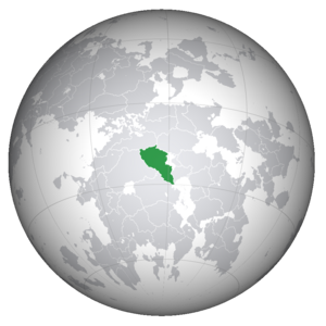
Kurzhistan, formally known as the Kurzhi People's Republic of Kurzhistan, is a Country located in the region of Central Thrismari inside the continent of Thrismari on Anteria. It is geographically located in the Central Thrismarian highlands, and borders Bashkaristan to its north, Abjekistan to its West and Encessia to its south. Kurzhistan has a population of 35.5 million people as of 2022.
Buznar is the capital and Gulnar is the largest city of the country. Kurzhistan comprises of Twenty six provinces and five districts of importance.
Etymology
Kurzhistan is the common name utilised for the Kurzhi People's Republic of Kurzhistan and has been regarded as the only name that the nation is known as, however that couldnt be further from the truth, Kurzhistan's original termology stems from the yaddak era, when the area was known as Qurzi-sthan or land of the Qurz which was the yaddak abbreviation for the Kurzh People.
As time went on however, the Yaddak's gradually latinised the name, and Qurz became Kurzh while Qurz-sthan came to be known as Kurzhi-stan or Land of the Kurzh, this termiology continued and the region came to be called by its latinized version, i.e Kurzhistan, instead of the generic Qurzsthan, which happened mostly due to the passage of time and the changing linguistics of the abjekh people with names being made easier to memorise and to pronounce, so that administrative works could be easily done.
However, even after kurzhi's won their independence from the yaddaks in the 1910's, this termiology of the yaddaks continued, and the Qurzi's identified themselves as Kurzhi's and their nation as Kurzhi-stan rather than Qurzi-sthan mostly due to the cultural influence of the abjekhs on the kurzhi's as a result of a prolonged administration of kurzhi areas, by the abjekhi royal government that went on for several centuries.
Geography
Political geography
Kurzhistan is located in Central Thrismari, just beside of the Marmor Sea. It is bordered by the Great golden raj to the north, Abjekistan to the west and southwest, Encessia to the south west, and hold's out as one of the largest state's located entirely inside the continent of thrismari.
Kurzhistan is divided into twenty one provinces. The Provinces are divided into a total of seventy two districts, which are further divided into sub-districts. The capital Buznar is the second largest city in Kurzhistan, and the metropolitan area is a province on its own. Gultan is in northern Kurzhistan which is the largest city. Buznar and Hazrat are Kurhzistan's main ports on the Marmor Sea.
Physical geography
Kurzhistan's geographic landscape is far more complicated than one might assume at first, with most simply dismissing kurzhistan as a land of deserts and sand dunes, For starters, Kurzhistan lies on the central thrismarian highlands, which cover the central regions of thrismari, with its own steppes and desert regions, among which the most iconic are the Dehrani-Al-Sahmar Steppes, which serve as the major pasture grounds for the domesticated cattles of the kurzhi tribals and village folk.
The Dehrani-Al-Sahmar covers an area of about 200,000+ km sq, out of which, most of which is located in the western and north eastern parts of the nation, these are major pasture sites and farming areas for the tribal groups that reside in that area, mostly located at a few hundred metres from the sea level, these are sparsely inhabited and are mainly home to the short scrubs and bushes that inhibit the areas, along with the smaller wildlife that can be found there, along those steppes, like the kurzhi fox and the dehrani gazzeles, though the most iconic part of these steppes are the rivers that flow through that area and cause large water reserves to form during the short monsoon season.
The steppes were in turn the result of the main river flowing through the northern reaches of the region all the way into the Kurzat Deserts, where it results in the formation of the well known Al-Huati Oasis's, though the river itself, feeds and nurtures the entirity of the people, who depend on it and its smaller tributaries for their farming and agricultural requirements,
The Adanshar River flows from the northern temperate regions, to the kurzat deserts, meeting with the Al-Huati oasis in the process, while a tributary of that river, flows directly towards the sea, giving rise to the steppes in the process. The Adanshar's length streches on to an impressive 425 kms and with a width of around 12.5 metres, its flowing results in the cultivable land necessary for the tribals and the rural people to grow their crops on, thus providing the state with its much needed needs.
While these serve, as the landscapes of what one would consider as the entirity of kurzhistan, there are massive mountain ranges that cover the western sides of the nation, from the violent winds that rage in that area, and act as an natural barrier against foreign intervention of any sorts. The Al-Khadur Mountain ranges are the main mountains that cover the region, reaching at an average height of 3000+ metres, these mountains are one of the most rugged mountain ranges in the region, and serve as one of the major tourist attractions in the nation.
The Mountains are home to some of the rare tundra fauna and flora that can be seen only in cold regions, which include the Mountain goat, the snow leopard, and several forms of lichens and moss in the valleys which are located beside the mountains and other regions, and can be a pretty different environment from the rest of the region.
Climate
The most striking feature of the climate of kurzhistan is the contrast of it. Between the humid short Mediterranean coast of it in the south and the arid desert regions lies the semiarid steppe zone extending across one-quarters of the country and bordered on the west by the Al-Khadur Mountains and the temperate forests, on the north by the border with bashkaristan, and on the southeast by the afore mentioned mountains
Rainfall in the temperate areas of the nation in the north is fairly abundant, annual precipitation ranging between 860 and 1,120 millimeters. Most of the rain, carried by winds from the Marmor seas, falls between Junuary and june. The annual mean temperatures range from 12°C in January to 30°C in july. Because the high ridges of the Al-Khadur mountains catch most of the rains clouds passing through abjekistan, the Steppes, located east of these mountains, is in a relatively arid zone with warm, dry winds and scanty rainfall. Frost is unknown in any season, although the peaks of the Al-Khadur are sometimes snow-covered.
In the southeast and southern regions of the nation, the humidity decreases, and annual precipitation falls below 100 millimeters. The scanty amounts of rain, moreover, are highly variable from year to year, causing periodic droughts. In the barren stony desert south of the seryat ranges, temperatures in July often exceed 45 °C. Sandstorms, common during February and May, damage vegetation and prevent grazing. North of the desert ranges and east of the Al-Khadur lie the vast steppes of the plateau, where cloudless skies and high daytime temperatures prevail during the summer, but frosts, at times severe, are common from November to March. Precipitation averages 250 millimeters a year but falls below 200 millimeters in a large belt along the southern desert area. In this belt, only the Adanshar river provide sufficient water for settlement and cultivation.
History
Prehistoric Era
Modern day Kurzhi's arrived in the area of central thrismari in the 3,000-1,000 BCE period, while this is not clear how they survived in such an environmemt, some documents and remains show that the Early Kurzhi's were mostly hunter gatherers and gathered fruits, nuts and berries from the trees and bushes that they found around them, and hunted small herbivores by using stone tools and bone blades, the later being a speciality of the Kurzhis.
As time moved on the Kurzhi's started to settle down into small communities based inside caves or in the hollow trunks of huge trees, with an average community comprising of about 7-14 members, some communities even united to form larger communities which went as far to comprise of about an estimated one hundred people.
The Kurzhis remained mostly as hunter gatherers from the early 6,000 BCE to about 4,000 BCE, after which they slowly started to advance towards the Age of farming and domestification.
As time advanced the kurzhis slowly began to develop their own set of small farms where they started to farm their first set of vegetables which typically included wheat grains, wild potatoes, etc, in the northern regions of modern day kurzhistan, though due to the highly desertificated structure of that area the kurzhi's couldnt modernize their farming tactics, though they did manage to domesticate their first range of animal life in the early 1000's-500 BCE,
The animals generally included cattles for example, the thrismarian camels and the kurzhi red cow, The Animals were used for mainly plowing and scathing the fields of the kurzhi Tribal land holdings, as well as to develop more advanced methods of seperating the waste products of the wheat from the actual crops.
The farming tactics of prehistoric kurzhi's generally included usage of less water consuming seeds of mostly wheats and wild potatoes, and to use a fairly irrigated field for their cultivation, which mostly refers to the northern temparate lands of kurzhistan and the steppes regions, where two rivers contact, which results in excellent farming regions.
The kurzhi's used mostly stone -tools like stone hoe and stone scathe's for sowing and harvesting the crops, after their maturation period. Though the harvests were usually low, the kurzhi's managed to supplement them with the livestocks they had, for example they used the "camel's meat and milk" harvested and collected from the individual cows and camels, as their main secondary food source during the pre historic times.
Tribes and communities
As the Kurzhi's slowly began to advance from hunter gatherers to farmers and dairy farmers, they started to form their own small tribes and societies besides the Adamshar river basin, with the first ones being on the northern parts of the region, most of these tribes were backwards and relied on fur and animal trade to feed themselves, with most of that being conducted with the yaddaks, who in return would provide them with all sorts of necessities and other luxury items, Though even if there was a flourishing trade between the two, relations were never amicable between them, kurzhi tribes regularly raided into yaddak territory and vice versa,
As the first century AD came, these tribes began to be even more bitter, not just against the yaddak's but now, against themselves as well, its presumed that these tribes had quarrels among them related to inter-marrial relations and religious schism, which caused them to be always be embroiled in conflict and schism. The largest of the Kurzhi tribes was the Arazhan which mainly occupied the regions constituting the modern day, Kurzat Deserts and depended mainly upon slave trade and trafficking to earn revenues, which made them seem like raiders to the other neighbouring tribal groups, which caused increased tensions between them, however despite being located inside of a desert, the Arazhan Tribe developed a large road network which streched all the way from the kurzat to the Al-Khadur and facilited largely in the export of goods and people to the yaddaks and neighbouring tribes.
By the third century AD, the tribal groups began to further diverge as political and social changes between them made their relations worser, which in turn caused two major wars, between the Arazhan's and the Shir-han's in which the later came out on top, and the Arazhan's faced a devastating defeat, which was one of the major causes for the downfall of them. While all this chaos was happening, there was the yaddak empire that was growing in the west, and had grew to encompass much of the modern day state of Abjekistan, which would soon also capture the kurzhi lands, and subjugate them for years to come.
Medieval Era
By the 7th century AD, the situation was dire in the kurzhi region, as constant infighting had almost diminished the tribe's ability to unite and fight off an foreign invader, who tried to invade their lands, and resist them, And thats what the Yaddak's took advantage of, As the Arazhan Tribe collapsed, and the last chief died, the tribal lords began to argue over their right to succeed the chief and, put no heed to the growing numbers of yaddak raids, into kurzhi regions. By the mid 7th century AD, the Yaddaks had launched a full scale military conquest, for the conquest of Qurzsthan, which would be acheived in just over a few months, as the tribals were far too outdated and disunited to resist an yaddak invasion, of the region.
By the Eighth century AD, the entirity of modern day kurzhistan was firmly under the control of the yaddak empire, and a list of noble families were made incharge of the administration of the Qurzsthani region of the Yaddak empire, with the nobles later being known as the Yanak-dar's or the people who worked for the yaddaks.
The Ruhiat dynasty, was the first one to administrate the qurzsthan region, of the yaddak empire, Under its rule, the economy of Qurzsthan developed, from a mostly nomadic styled trading one to a settled agricultural one, with various settlements being made besides the Adamshar river, and those later developing into bustling towns and cities; which are inhabited to this date.
The Ruhiat's ruled from the 7th century to the 12th century CE, and had 3 notable yanak-dars who are still been taught to the kurzhi children in school.
Suleiman Ruhiat was the first yanak-dar to gain the authority to rule qurzsthan, and ruled from (712-756). Under his rule, Qurzsthan developed its economic and social conditions, as the region developed from an nomadic sort of living to an settled one, with settlements being constructed near the adanshar river basin, and in the steppes region, athough, those would take time to develop into permanent towns and cities.
In terms of social development, he uplifted the role of women in society, made laws that punished adultery, made reforms to change the kurzhi language, and promoted thoughts of arts and culture across the region.
After Ruhait's death in 756 AD, his son Suleiman Sheihat succeeded to the position of the yanak-dar in 756 AD, His rule from (756-802) was marked by huge economic and administrative reforms, and the reorganization of the traditional positions inside the Qurzhsthani Royal administrative system. He reformed the administrative divisions of the nation, and categorized each province with its population, something that was not even done in Yaddakstan proper,
He reduced restrictions on trade with the outside world, and reduced tarrif rates for traders, across the northern thrismari region, which resulted in an huge economic boom, during the 9th and 10th century, and led to the increasing popularity of the yanak-dars, in qurzhsthan. Sadly Sheihat, passed away in 802 AD, at the age of 87. After his death, his son Murat, took over but he couldnt do much but stabilise the rule of the yanak-dars in the region by building up the Qurzhi Army during his reign. He died in 886, and after his death, for several centuries, no other great yanak-dars rose to the throne. It would take until the 16th century for the last of the great yanak-dars to rise to the position, and cement his rule, which would also be the seeds of demise for the yaddak rule in kurzhistan.
