Khasa: Difference between revisions
Jump to navigation
Jump to search
(Created page with "{{Infobox settlement | name = Khasa | native_name = | native_name_lang = | settlement_type = Capital City | image_skyline...") |
No edit summary |
||
| (2 intermediate revisions by the same user not shown) | |||
| Line 16: | Line 16: | ||
| nickname = | | nickname = | ||
| motto = | | motto = | ||
| image_map = | | image_map = File:Khasa Pushpin Map.png | ||
| map_alt = | | map_alt = | ||
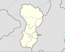
| map_caption = | | map_caption = Location of Khasa in [[Namdatka]]. | ||
| pushpin_map = Namdatka Borders and Rivers Miki Wap.png | | pushpin_map = Namdatka Borders and Rivers Miki Wap.png | ||
| pushpin_map_alt = | | pushpin_map_alt = | ||
| pushpin_map_caption = Location of Khasa in Namdatka. | | pushpin_map_caption = Location of Khasa in Namdatka. | ||
| pushpin_label_position | | pushpin_label_position = 0.50 0.50 | ||
| coordinates = <!-- {{Coord}} --> | | coordinates = <!-- {{Coord}} --> | ||
| coor_pinpoint = | | coor_pinpoint = | ||
| Line 97: | Line 97: | ||
| footnotes = | | footnotes = | ||
}} | }} | ||
Khasa ({{wp|Dzongkha|Drukkha}}: ག་འདྲ་) is the capital and largest city in [[Namdatka]]. It is situated close to the eastern border with [[Mahana]], roughly 50 miles away, and around the Dzongkahuea Valley which provides the city a temperate climate. The historic and ancient capital of Lwhang Techwa in the western regions. | |||
==Name== | |||
==History== | |||
==Geography== | |||
==References== | |||
{{reflist}} | |||
[[Category:Namdakta]] | |||
Latest revision as of 15:21, 14 May 2023
Khasa | |
|---|---|
Capital City | |
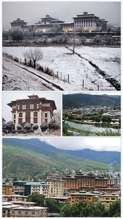
 From top, left to right: Chokzay Royal Palace, National Library of Namdatka, an aerial view of Khasa, Tzia Business District | |
 Location of Khasa in Namdatka. | |
| Country | Namdatka |
| Population (2018) | |
| • Total | 163,930 |
Khasa (Drukkha: ག་འདྲ་) is the capital and largest city in Namdatka. It is situated close to the eastern border with Mahana, roughly 50 miles away, and around the Dzongkahuea Valley which provides the city a temperate climate. The historic and ancient capital of Lwhang Techwa in the western regions.