Crovania: Difference between revisions
m (fixed file type) |
Tag: Undo |
||
| Line 7: | Line 7: | ||
| image_alt = | | image_alt = | ||
| image_caption = | | image_caption = | ||
| image_flag = FlagCrovania. | | image_flag = FlagCrovania.png | ||
| flag_alt = Flag of Crovania Amt. | | flag_alt = Flag of Crovania Amt. | ||
| image_seal = | | image_seal = | ||
Latest revision as of 01:28, 25 October 2022
Crovania | |
|---|---|
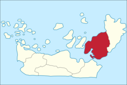
 Location of Crovania on the Island of Crovaney, Caproney. | |
| Country | Caproney |
| Capital and largest city | Aervigh |
| Area | |
| • Total | 386.2 km2 (149.1 sq mi) |
| • Rank | 2nd |
| Population (2020) | |
| • Total | 42,229 |
| • Density | 109.4/km2 (283/sq mi) |
| Demonym(s) | Crovanian, Crofanlander |
| Time zone | UTC+1 (CET) |
Crovania; Caprish Crofanye, is an amt in Caproney on the southern part of the island of Crovaney, the second most populous of all nine amts, bordering Norhelm in the north, the Reyde strait in the south, the Sylteys to the east across the Sarcsund and the Angobught, and the Atlantic Ocean (North Sea) to the west. In 2020 it had a population of 42,229. The administrative centre of the amt and its largest city is Aervigh, the largest city in Caproney.
Etymology
Crovania Amt takes its name from the short-lived amt of the same name that comprised the northern part of the current region between 1919 and 1942, prior to which it was referred to as Crofanland. Both names refer to the city of Crofan, the ancient capital of the Kingdom of Caproney on the island of Crovaney (which also takes its name from the city). The Caprish name for the amt is 'Crofanye'. The last part of the name Crovania, '-ia' is a Latin suffix, which is calqued as the Caprish suffix '-ye.'
Coat of Arms
The Coat of Arms of Crovania is a modern one, created in 1919 as the arms of the short-lived Vigheland amt. The arms are yellow with a blue cross. The design is a recoloured version of the red and white arms of the City of Aervigh with the colours of Crofan, blue and yellow. The arms and flag were adopted in 1942 during the British occupation of Caproney during the Second World War.
History
Crovania became a Lean (fief) in the 16th century called Crofanlean, and then also included all of Uodinsehunder, while Terryngehunder and Eastevighe was part of the Sylteylean. Prior to this, the island of Crovaney had no official subdivisions, and local jurisdictions often overlapped. In 1666, the Lean became an Amt (county), and with this the Syltic Crovaney territories were ceded to the amt, now called Amt Crofanland (Amycht Crofvanlund in Early Modern Caprish). In 1740 the western portion of Uodinsehunder became part of Norhelm, bringing the amt to its present borders. In 1919, the amt was split in twain, with the northern portion centred around Crofan being renamed 'Crovania', or Crofanye in Caprish, while the south was named Vigheland. The amts of Crovania and Vigheland were reunited in 1942 under the British occupation, but retaining the name Crovania.
Geography
As a geographical term, Crovania is recent, originally being called Crofanland. Crovania Amt is located on the south-western half of the island of Crovaney, the second largest island in the Caprish Archipelago.
Like the rest of the archipelago, Crovania is relatively flat with bands of rolling hills made of glacial moraine. The most important geographic feature is the Vighe, a natural harbour on the Reyde strait at the mouths of both the rivers Y and Cor and enclosed by the Angey and Terrynge peninsulas.
The Vighe is the location of the Vigheland metropolitan region (also known as Aervigh-Inhafen), the largest urban area in the country, mainly comprising of the capital city of Aervigh and the port town of Inhafen and surrounding towns.
There are many towns in Crovania other than Aervigh and Inhafen. Further up the river Y is the town of Caermagh, and up the river Cor is Crofan, the historic capital and third largest city in Crovania.
Economy
During the industrial revolution, Inhafen was known as the 'Manchester of Caproney' due to its extensive textile mills. The rivers Y and Cro provided extensive power to watermills, many of which were involved in textile production. Today, many of the old mill buildings are used for art studios, office space, and, more recently, apartments.
While its role as a major shipping hub has waned, Aervigh remains a major North Sea port.
Tourism makes up a large portion of the Crovanian economy, being the second most visited region in Caproney after Cenyngs.
Government
An amt is the chief local administrative area in Caproney. The whole of the Caproneys is divided into 9 amten. An amt is also an election area, with votes taking place every 4 years using proportional representation since 2008. Crovania is apportioned 17 seats in the national legislature, or 28% of the Folcshus. Politically, Crovania leans left, with 13/17 Crovanian ealdermen belonging to the AP-SD-Greane coalition.
The government of Crovania is the Crovanian Amt Municipality (Crofanyeramtiscegemead), which elects 33 amtsmen who run the Amtsding, a county council. Heading the Amtsding is the Forsteamtsman. Since 2016, the Crovanian Amtsding has been run by Sofia Spreccer, the amt mayor.
Subdivisions
- Crofanhunder (includes Crofan)
- Dosenland (includes Cofeore, Uaeg, and Batun)
- Uodinsehunder (includes Uodins)
- Aervighunder (includes Aervigh, Ransehod, and Farne)
- Vighelandhunder (includes Vicgh and Inhafen)
- Terrynge (includes Salemborg and Forc)

