Tsanga: Difference between revisions
No edit summary |
|||
| (22 intermediate revisions by the same user not shown) | |||
| Line 1: | Line 1: | ||
{{Infobox country | {{Infobox country | ||
|conventional_long_name = | |conventional_long_name = Federal Republic of Tsanga | ||
|native_name = ''Shirikhuri ya Tsanga'' | |native_name = ''Shirikhuri ya Tsanga'' | ||
|image_flag = [[File:Tsangan flag.png|160px]] | |image_flag = [[File:Tsangan flag.png|160px]] | ||
|flag_border = on | |flag_border = on [[File:File.png|200px|thumb|left|alt text]] | ||
|image_coat = [[File: | |image_coat = [[File:Tsangan_coat_of_arms.png|110px]] | ||
|symbol_type = National Emblem | |symbol_type = National Emblem | ||
|national_motto = "Udugu wa Usawa wa Uhuru" | |national_motto = "Udugu wa Usawa wa Uhuru" | ||
| Line 12: | Line 11: | ||
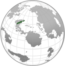
|image_map = [[File:Location of Tsanga.png|220px]] | |image_map = [[File:Location of Tsanga.png|220px]] | ||
|map_caption = Location of Tsanga | |map_caption = Location of Tsanga | ||
|capital = | |capital = Anklomji | ||
|largest_city = Lacag | |largest_city = Lacag | ||
|official_languages = Mrefuti | |official_languages = Mrefuti | ||
| Line 19: | Line 18: | ||
|demonym = Tsangan | |demonym = Tsangan | ||
|government_type = Federal semi-presidental Republic | |government_type = Federal semi-presidental Republic | ||
|leader_title1 = | |leader_title1 = President | ||
|leader_name1 = [[Casimir Bergen]] | |leader_name1 = [[Casimir Bergen]] | ||
|leader_title2 = | |leader_title2 = Prime Minister | ||
|leader_name2 = Sabah Shamoud | |leader_name2 = Sabah Shamoud | ||
|legislature = | |legislature = M'kutano | ||
|upper_house = | |upper_house = Huri-juu | ||
|lower_house = | |lower_house = Huri-chini | ||
|established_event1 = | |established_event1 = Unification | ||
|established_date1 = 12th | |established_date1 = 12th March 1625 | ||
|established_event2 = | |established_event2 = Monarchy abolished | ||
|established_date2 = | |established_date2 = 1st December 1873 | ||
|area_km2= | |area_km2= 662,937 | ||
|area_sq_mi = | |area_sq_mi = 255,961 | ||
|population_estimate = 68, | |population_estimate = 68,718,000 | ||
|population_estimate_year = | |population_estimate_year = February 2026 | ||
|population_census = | |population_census = 72,612,809 | ||
|population_census_year = 2018 | |population_census_year = 2018 | ||
|population_density_km2 = | |population_density_km2 = 115.8 | ||
|population_density_sq_mi = 122.97 | |population_density_sq_mi = 122.97 | ||
|GDP_PPP = | |GDP_PPP = 1.082 trillion Fedhas | ||
|GDP_PPP_rank = | |GDP_PPP_rank = | ||
|GDP_PPP_year = | |GDP_PPP_year = 2026 | ||
|GDP_PPP_per_capita = | |GDP_PPP_per_capita = 14,910 Fedhas | ||
|GDP_nominal = | |GDP_nominal = 1.087 trillion Fedhas | ||
|GDP_nominal_year = | |GDP_nominal_year = 2026 | ||
|GDP_nominal_per_capita = | |GDP_nominal_per_capita = 18,503 Fedhas | ||
|Gini = | |Gini = 38.2 | ||
|Gini_year = | |Gini_year = 2026 | ||
|HDI_year = | |HDI_year = 2026 | ||
|HDI = 0. | |HDI = 0.761 | ||
|HDI_change = | |HDI_change = decrease | ||
|currency = | |currency = Fedha | ||
|currency_code = | |currency_code = TFD | ||
|time_zone = UTC-6 | |time_zone = UTC-6 | ||
|date_format = dd-mm-yyyy | |date_format = dd-mm-yyyy | ||
| Line 57: | Line 56: | ||
|cctld = .ts | |cctld = .ts | ||
|iso3166code = LTA | |iso3166code = LTA | ||
|calling_code = + | |calling_code = +16 | ||
}} | }} | ||
'''Tsanga''' (pronounced [Tsɑːŋgə]), officially the '''Federal Republic of Tsanga''', is a country in North Takaria. It is the second most populous country in Takaria after Locotima, and one of the most densely populated nations on Telrova. Tsanga is situated between the Nyeupe-bluu Mountains | '''Tsanga''' (pronounced [Tsɑːŋgə]), officially the '''Federal Republic of Tsanga''', is a country in North Takaria. It is the second most populous country in Takaria after [[Locotima]], and one of the most densely populated nations on Telrova. Tsanga is situated between the Nyeupe-bluu Mountains to the north, and the Ndefu river system to the south; it covers an area of 662,937 square kilometres (255,961 sq mi), with a population of almost 73 million within its 5 constituent states and single federal territory. Tsanga borders Austerland to the north, and Locotima to the south. The nation's capital is Anklomji and its financial centre is Lacag; the largest urban area is the Mto. | ||
The post-Fakhri period was tumultuous, with many military coups and coup attempts shaking the country from 2008 to 2026. Tsanga was under Emergency Law from 2025 to 2026, effectively suspending most constitutional protections for citizens. In 2026, Tsanga was engulfed by a brief civil war, ending in the expulsion of Nia Sauda and the election of Musa Imari in the 2026 general elections. | The post-Fakhri period was tumultuous, with many military coups and coup attempts shaking the country from 2008 to 2026. Tsanga was under Emergency Law from 2025 to 2026, effectively suspending most constitutional protections for citizens. In 2026, Tsanga was engulfed by a brief civil war, ending in the expulsion of Nia Sauda and the election of Musa Imari in the 2026 general elections. | ||
==Etymology== | |||
The name Tsanga is derived from the river Tsan, meaning "Land of the river Tsan". First attested in the T'vezian king Musa Mudde II's 627 'Usimamizi wa Ardhi'. The name is not completely understood and is difficult to trace back earlier than the 4th century AD, but a connection to the Proto-Mrefuti word szean ("to pray", "sky", "god") and its derivative seen ("personhood", "grounded") is proposed by Shabani Nonda. The meaning may be further extended to "people" or "to settle", and so, in the derivative, the "settled people". Tribal groups in North Takaria with phonologically close names were frequently described in similar terms, as the San-nit, a component of the "Five Tribes", which during the 4th century were portrayed as both: "religious" and "settled". | |||
==History== | |||
===Prehistory=== | |||
===Antiquity=== | |||
===Middle Ages=== | |||
===Tsangan Confederation=== | |||
==Geography== | |||
===Climate=== | |||
===Biodiversity=== | |||
==Politics== | |||
===Constituent states=== | |||
====Largest cities==== | |||
{{Largest cities | |||
| name = Largest cities of Tsanga | |||
| country = Tsanga | |||
| stat_ref = 2018 data from [[Tsangan Department of Statistics]] | |||
| list_by_pop = <!-- link to the list of cities in the given country, if possible sorted by population --> | |||
| class = nav blue | |||
| div_name = State or territory | |||
| div_link = <!-- the template will automatically create a link for "div_name of country" (e.g. Provinces of Chile), if this doesn't work you can use this field --> | |||
| city_1 = Lacag | |||
| div_1 = Tsan{{!}}Tsan | |||
| pop_1 = 5,264,702 | |||
| img_1 =Aerial Guayaquil.jpg | |||
| city_2 =Mutare | div_2 =Tsan{{!}}Tsan |pop_2 =2,022,351 |img_2 =Cartagena skyline, Colombia.jpg | |||
| city_3 =Hlatacuane | div_3 =Mpaka{{!}}Mpaka |pop_3 =1,881,567 |img_3 =Belo Horizonte (2).jpg | |||
| city_4 =Nampula | div_4 =Tsan{{!}}Tsan |pop_4 =1,619,176 |img_4 =Illimani visto desde La Paz.jpg | |||
| city_5 =Nsanji | div_5 =Nje{{!}}Nje |pop_5 =998,944 | |||
| city_6 =Maputo | div_6 =Shambani{{!}}Shambani |pop_6 =932,784 | |||
| city_7 =Kapiri Mposhi| div_7 =Ardhijuu{{!}}Ardhijuu |pop_7 =895,672 | |||
| city_8 =Bindura | div_8 =Nje{{!}}Nje |pop_8 =827,588 | |||
| city_9 =Namacurra | div_9 =Mpaka{{!}}Mpaka |pop_9 =766,189 | |||
| city_10 =Anklomji | div_10 =Tsangan Capital Territory{{!}}Tsangan Capital Territory |pop_10 =684,470 | |||
}} | |||
===Law=== | |||
===Foreign relations=== | |||
==Economy== | |||
[[Category:Nations on Telrova]] [[Category:Tsanga]] | |||
Latest revision as of 04:45, 25 November 2022
Federal Republic of Tsanga Shirikhuri ya Tsanga | |
|---|---|
| Motto: "Udugu wa Usawa wa Uhuru" "Brotherhood, Liberty, Equality" | |
| Anthem: "Ode to the Tsan" | |
 Location of Tsanga | |
| Capital | Anklomji |
| Largest city | Lacag |
| Official languages | Mrefuti |
| Recognised regional languages | Kuseam, Mpaki, Ardhijaan |
| Ethnic groups | Tsangan, Mpaki, Ardhijaan |
| Demonym(s) | Tsangan |
| Government | Federal semi-presidental Republic |
• President | Casimir Bergen |
• Prime Minister | Sabah Shamoud |
| Legislature | M'kutano |
| Huri-juu | |
| Huri-chini | |
| Establishment | |
• Unification | 12th March 1625 |
• Monarchy abolished | 1st December 1873 |
| Area | |
• Total | 662,937 km2 (255,961 sq mi) |
| Population | |
• February 2026 estimate | 68,718,000 |
• 2018 census | 72,612,809 |
• Density | 115.8/km2 (299.9/sq mi) |
| GDP (PPP) | 2026 estimate |
• Total | 1.082 trillion Fedhas |
• Per capita | 14,910 Fedhas |
| GDP (nominal) | 2026 estimate |
• Total | 1.087 trillion Fedhas |
• Per capita | 18,503 Fedhas |
| Gini (2026) | 38.2 medium |
| HDI (2026) | high |
| Currency | Fedha (TFD) |
| Time zone | UTC-6 |
| Date format | dd-mm-yyyy |
| Driving side | left |
| Calling code | +16 |
| ISO 3166 code | LTA |
| Internet TLD | .ts |
Tsanga (pronounced [Tsɑːŋgə]), officially the Federal Republic of Tsanga, is a country in North Takaria. It is the second most populous country in Takaria after Locotima, and one of the most densely populated nations on Telrova. Tsanga is situated between the Nyeupe-bluu Mountains to the north, and the Ndefu river system to the south; it covers an area of 662,937 square kilometres (255,961 sq mi), with a population of almost 73 million within its 5 constituent states and single federal territory. Tsanga borders Austerland to the north, and Locotima to the south. The nation's capital is Anklomji and its financial centre is Lacag; the largest urban area is the Mto.
The post-Fakhri period was tumultuous, with many military coups and coup attempts shaking the country from 2008 to 2026. Tsanga was under Emergency Law from 2025 to 2026, effectively suspending most constitutional protections for citizens. In 2026, Tsanga was engulfed by a brief civil war, ending in the expulsion of Nia Sauda and the election of Musa Imari in the 2026 general elections.
Etymology
The name Tsanga is derived from the river Tsan, meaning "Land of the river Tsan". First attested in the T'vezian king Musa Mudde II's 627 'Usimamizi wa Ardhi'. The name is not completely understood and is difficult to trace back earlier than the 4th century AD, but a connection to the Proto-Mrefuti word szean ("to pray", "sky", "god") and its derivative seen ("personhood", "grounded") is proposed by Shabani Nonda. The meaning may be further extended to "people" or "to settle", and so, in the derivative, the "settled people". Tribal groups in North Takaria with phonologically close names were frequently described in similar terms, as the San-nit, a component of the "Five Tribes", which during the 4th century were portrayed as both: "religious" and "settled".
History
Prehistory
Antiquity
Middle Ages
Tsangan Confederation
Geography
Climate
Biodiversity
Politics
Constituent states
Largest cities
| Rank | State or territory | Pop. | |||||||
|---|---|---|---|---|---|---|---|---|---|
 Lacag  Mutare |
1 | Lacag | Tsan | 5,264,702 |  Hlatacuane  Nampula | ||||
| 2 | Mutare | Tsan | 2,022,351 | ||||||
| 3 | Hlatacuane | Mpaka | 1,881,567 | ||||||
| 4 | Nampula | Tsan | 1,619,176 | ||||||
| 5 | Nsanji | Nje | 998,944 | ||||||
| 6 | Maputo | Shambani | 932,784 | ||||||
| 7 | Kapiri Mposhi | Ardhijuu | 895,672 | ||||||
| 8 | Bindura | Nje | 827,588 | ||||||
| 9 | Namacurra | Mpaka | 766,189 | ||||||
| 10 | Anklomji | Tsangan Capital Territory | 684,470 | ||||||

