St. Clarke County, Albion: Difference between revisions
| (3 intermediate revisions by the same user not shown) | |||
| Line 46: | Line 46: | ||
| government_type = County | | government_type = County | ||
| governing_body = [[St. Clarke County Board of Commissioners|Board of Commissioners]] | | governing_body = [[St. Clarke County Board of Commissioners|Board of Commissioners]] | ||
| leader_title = | | leader_title = Board President | ||
| leader_name = Elvis Verity ([[Progressive Party (Ibica)|P]]) | | leader_name = Elvis Verity ([[Progressive Party (Ibica)|P]]) | ||
| leader_title2 = County Board | | leader_title2 = County Board | ||
| Line 119: | Line 119: | ||
===Major highways=== | ===Major highways=== | ||
Following on the well-established position of St. Clarke as a transportation hub, the Interstate highway network maintained St. Clarke as a hub of that network, as well as serving the travel needs within the region. | Following on the well-established position of St. Clarke as a transportation hub, the Interstate highway network maintained St. Clarke as a hub of that network, as well as serving the travel needs within the region. | ||
'''Interstate Highways'''<br /> | '''Interstate Highways'''<br /> | ||
* [[Image:I-70.svg|20px]] [[Interstate 70]] | * [[Image:I-70.svg|20px]] [[Interstate 70]] | ||
| Line 125: | Line 125: | ||
* [[Image:I-170.svg|20px]] [[Interstate 170 (Albion)|Interstate 170]] | * [[Image:I-170.svg|20px]] [[Interstate 170 (Albion)|Interstate 170]] | ||
* [[Image:I-270.svg|20px]] [[Interstate 270 (Albion)|Interstate 270]] | * [[Image:I-270.svg|20px]] [[Interstate 270 (Albion)|Interstate 270]] | ||
''' | '''Ibican Routes'''<br /> | ||
* [[Image:US 50.svg|20px]] [[Ibican Route 50]] | * [[Image:US 50.svg|20px]] [[Ibican Route 50]] | ||
* [[Image:IR-50-Alt.png|20px]] [[Ibican Route 50 Alternate]] | * [[Image:IR-50-Alt.png|20px]] [[Ibican Route 50 Alternate]] | ||
| Line 144: | Line 144: | ||
* [[Image:St. Clarke Co. 35.png|20px]] [[St. Clarke County Route 35]] | * [[Image:St. Clarke Co. 35.png|20px]] [[St. Clarke County Route 35]] | ||
* [[Image:St. Clarke Co. 40.png|20px]] [[St. Clarke County Route 40]] | * [[Image:St. Clarke Co. 40.png|20px]] [[St. Clarke County Route 40]] | ||
===Airports=== | ===Airports=== | ||
| Line 181: | Line 180: | ||
===Historic Site=== | ===Historic Site=== | ||
* [[Wesley Castle]] | * [[Wesley Castle]] | ||
===Protected Areas=== | |||
* [[Clarke Beach State Park]] | |||
* [[Columbia Woodlands County Park]] | |||
* [[Naper State Park]] | |||
* [[North Ridge Park (St. Clarke)|North Ridge City Park]] | |||
* [[Spring County Park]] | |||
* [[Wesley Castle National Historic Site]] | |||
* [[Xavier Memorial Park]] | |||
===Adjacent counties=== | ===Adjacent counties=== | ||
| Line 189: | Line 197: | ||
* [[James County, Albion|James]] – southwest | * [[James County, Albion|James]] – southwest | ||
* [[Lufkin County, Albion|Lufkin]] – west | * [[Lufkin County, Albion|Lufkin]] – west | ||
==Education== | ==Education== | ||
Latest revision as of 21:08, 17 May 2023
St. Clarke County, Albion | |
|---|---|
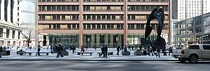
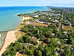
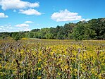
From top, left to right: St. Clarke Circuit Court at Municipal Plaza, Bayside neighbors in Saints Beach, Columbia Woodlands County Park | |
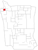
 Location within Albion | |
| Country | Ibica |
| State | Albion |
| Metro area | Greater St. Clarke |
| Organized | 1485, |
| Named for | City of St. Clarke |
| County seat | St. Clarke |
| Incorporated municipalities | 25 |
| Government | |
| • Type | County |
| • Body | Board of Commissioners |
| • Board President | Elvis Verity (P) |
| • County Board | 17 commissioners |
| Area | |
| • County | 1,635 sq mi (4,230 km2) |
| • Land | 945 sq mi (2,450 km2) |
| • Water | 690 sq mi (1,800 km2) |
| • Metro | 10,874 sq mi (28,160 km2) |
| Population (2020) | |
| • County | 3,042,708 |
| • Density | 3,200/sq mi (1,200/km2) |
| Time zone | UTC+10 (Central) |
| Postal Codes | AB0501-AB0539 |
| Area code | 412 |
St. Clarke County is the most populous county in the Ibican state of Albion and the xth-most-populous county in the country. nearly than 60% of all residents of albion live within St. Clarke County. As of 2020, the population was 3,042,708. The county seat is St. Clarke, the most populous city in Albion and the third most populous city in Ibica. The county is at center of the Greater St. Clarke metropolitan area.
St. Clarke County was organized in 1485. It achieved its present boundaries in 1921. There are more than 100 local governmental units and 25 municipalities located wholly or partially within St. Clarke County, the largest of which is St. Clarke. The city is home to approximately 49% of the entire county's population. County government is overseen by the St. Clarke County Board of Commissioners, and countywide state government offices include the Circuit Court of St. Clarke County, the St. Clarke County State's Attorney, the St. Clarke County Sheriff, and the St. Clarke County Assessor.
St. Clarke County's population is larger than that of 5 different States and Territories of Ibica. St. Clarke County is included in the Greater St. Clarke metropolitan area, which has a population of approximately 4.6 million people.
History
St. Clarke County was organized in 1485, on of the original counties of Albion, and one of the five "Home Counties" that make up modern day Albion. Over the years, the county has been chipped down to its current size from making up the northwest quarter of the state.
St. Clarke County is nearly completely developed, with little agricultural land remaining near the outer county boundaries. All land in the county is incorporated into municipalities, leading to the state allowing the county to take on a home rule charter, as most of the traditional duties of the county offices would be handled by the cities otherwise.
Government
The government of St. Clarke County is primarily composed of the Board of Commissioners headed by the President of the County board, other elected officials such as the Sheriff, State's Attorney, Treasurer, Board of Review, Clerk, Assessor, Recorder, Circuit Court judges, and Circuit Court Clerk, as well as numerous other officers and entities. St. Clarke County is the only home rule county in Albion. The St. Clarke County Code is the codification of St. Clarke County's local ordinances. St. Clarke County's current County Board president is Elvis Verity.
The Circuit Court of St. Clarke County, which is an Albion state court of general jurisdiction is funded, in part, by St. Clarke County, and accepts more than 1.2 million cases each year for filing. The St. Clarke County Department of Corrections, also known as the St. Clarke County Jail, is the largest single-site jail in the nation. The St. Clarke County Juvenile Detention Center, under the authority of the Chief Judge of the court, is the first juvenile center in the nation and one of the largest in the nation. The St. Clarke County Law Library is the second-largest county law library in the nation.
The Bureau of Health Services administers the county's public health services and is the third-largest public health system in the nation. Three hospitals are part of this system, along with over 30 clinics.
The St. Clarke County Department of Transportation is responsible for the design and maintenance of roadways in the county. These thoroughfares are composed mostly of major and minor arterials, with a few local roads.
The St. Clarke County Forest Preserves, organized in 1915, is a separate, independent taxing body, but the St. Clarke County Board of Commissioners also acts as its Board of Commissioners. The district is a belt of 69,000 acres (280 km2) of forest reservations surrounding the city of St. Clarke. The Georgetown Zoo (managed by the St. Clarke Zoological Society) is located in the forest preserves.
Infrastructure
Railway network
The next major technology for transportation was railroads. St. Clarke and the towns along the river understood the value of being a hub of a major network. Rail lines spurred out from St. Clarke by the 1850s, with major growth in the rail network for freight and passenger transportation coming after the transcontinental railroads were completed, coast to coast across Ibica, stopping in St. Clarke.
Major highways
Following on the well-established position of St. Clarke as a transportation hub, the Interstate highway network maintained St. Clarke as a hub of that network, as well as serving the travel needs within the region.
Interstate Highways
Ibican Routes
State Highways
County Highways
 St. Clarke County Route 5
 St. Clarke County Route 10
 St. Clarke County Route 15
 St. Clarke County Route 17
 St. Clarke County Route 20
 St. Clarke County Route 21
 St. Clarke County Route 30
 St. Clarke County Route 35
 St. Clarke County Route 40
Airports
When the age of air travel began in the 20th century, the original St. Clarke International Airport was built on one square mile of land and served as the major St. Clarke area airport from 1927 to 1979. The old airport has since been bought by the Ibican Department of Defense, and now serves as Marine Corps Air Station St. Clarke and Naval Air Station St. Clarke. As air travel became more important for passenger travel, and then for select freight commodities, the new St. Clarke International Airport was built north of the city in nearby Forest Park, making use of the shuttered air airfield at Fort St. Clarke.
Communities
Cities
Historic Site
Protected Areas
- Clarke Beach State Park
- Columbia Woodlands County Park
- Naper State Park
- North Ridge City Park
- Spring County Park
- Wesley Castle National Historic Site
- Xavier Memorial Park
Adjacent counties
- Bay of Albion – northwest
- Harris – north
- Chambers – east
- Stone – south
- James – southwest
- Lufkin – west
Education
Colleges and universities
- St. Clarke College
- St. Clarke Community College System
- University of Albion at St. Clarke
- Albion Christian University
- St. Clarke Institute of Technology


