Kitaubani: Difference between revisions
m (→Religion) |
mNo edit summary |
||
| (10 intermediate revisions by the same user not shown) | |||
| Line 1: | Line 1: | ||
{{Infobox country | {{Infobox country | ||
| conventional_long_name = Kingdom of Kitaubani | |||
|conventional_long_name = Kingdom of Kitaubani | | native_name = उफ़ल्मे व कितुओप्वनि ({{wp|Swahili_language|KiUngwana}})<br/>''Ufalme wa Kituopwani'' | ||
|native_name = | | common_name = Kitaubani | ||
|common_name = | | status = <!--Status of country, especially useful for micronations--> | ||
|status = | | image_flag = Kitaubanflag.png | ||
|image_flag = | | alt_flag = <!--alt text for flag (text shown when pointer hovers over flag)--> | ||
|alt_flag = | | flag_border = <!--set to no to disable border around the flag--> | ||
|flag_border = | | image_flag2 = <!--e.g. Second-flag of country.svg--> | ||
|image_flag2 = | | alt_flag2 = <!--alt text for second flag--> | ||
|alt_flag2 = | | flag2_border = <!--set to no to disable border around the flag--> | ||
|flag2_border = | | image_coat = File:Greater_Coat_of_Arms_of_Kitaubani.png | ||
|image_coat = | | alt_coat = <!--alt text for coat of arms--> | ||
|alt_coat = | | symbol_type = <!--emblem, seal, etc (if not a coat of arms)--> | ||
|symbol_type = | | national_motto = ऊमोज कतिक ऊतोफ़ौति<br/>''Umoja katika Utofauti'' ({{wp|Swahili_language|KiUngwana}}) | ||
|national_motto = | | englishmotto = Unity in Diversity | ||
|englishmotto = | | national_anthem = ''"Alfarma"''<br><small>"Majesty"</small><br>[[File:MediaPlayer.png|link=https://www.youtube.com/watch?v=8357OFGO-bM|210px]] | ||
|national_anthem = | | royal_anthem = <!--in inverted commas and wikilinked if link exists--> | ||
|royal_anthem = | | other_symbol_type = <!--Use if a further symbol exists, e.g. hymn--> | ||
|other_symbol_type = | | other_symbol = | ||
|other_symbol = | | image_map = | ||
|image_map = | | loctext = | ||
|loctext = | | alt_map = <!--alt text for map--> | ||
|alt_map = | | map_caption = Kitaubani (dark green) on the subcontinent of X | ||
|map_caption = | | image_map_size = 300px | ||
|image_map_size = | | image_map2 = <!--Another map, if required--> | ||
|image_map2 = | | alt_map2 = <!--alt text for second map--> | ||
|alt_map2 = | | map_caption2 = <!--Caption to place below second map--> | ||
|map_caption2 = | | image_map2_size = <!--Map size in number of pixels--> | ||
|image_map2_size = | | capital = Kwamuimepe | ||
|capital = | | coordinates = <!-- Coordinates for capital, using {{tl|coord}} --> | ||
|coordinates = | | largest_city = Kikambala | ||
|largest_city = | | largest_settlement_type = city | ||
|largest_settlement_type = city | | largest_settlement = <!--Name of largest settlement--> | ||
|largest_settlement = <!--Name of largest settlement--> | | official_languages = {{wp|Swahili_language|KiUngwana}} | ||
|official_languages = {{wp| | | regional_languages = {{wp|Lemba_language|Mwenye}}<br/>{{wp|Naandi_language|Chemwal}} | ||
| languages_type = <!--Use to specify a further type of language, if not official, national or regional--> | |||
| | | languages = <!--Languages of the further type--> | ||
|languages_type = | | languages_sub = <!--Is this further type of language a sub-item of the previous non-sub type? ("yes" or "no")--> | ||
|languages = | | languages2_type = <!--Another further type of language--> | ||
|languages_sub = | | languages2 = <!--Languages of this second further type--> | ||
|languages2_type = | | languages2_sub = <!--Is the second alternative type of languages a sub-item of the previous non-sub type? ("yes" or "no")--> | ||
|languages2 = | | ethnic_groups = {{Collapsible list | ||
|languages2_sub = | |||
|ethnic_groups = | |||
|titlestyle = background:transparent;text-align:left;font-weight:normal;font-size:100%; | |titlestyle = background:transparent;text-align:left;font-weight:normal;font-size:100%; | ||
|title = | | |title = | XX% {{wp|Swahili_people|WaUngwana}} | XX% {{wp|Lemba_people|Mwenye}} | XX% {{wp|Nandi_people|Chemwal}} | XX% {{wp|Mijikenda}} | 16% [[Kitaubani#Ethnicity|Other]] }} | ||
|ethnic_groups_year = 2023 | | ethnic_groups_year = 2023 | ||
|ethnic_groups_ref = | | ethnic_groups_ref = <!--(for any ref/s to associate with ethnic groups data)--> | ||
|religion = | | religion = {{Collapsible list | ||
{{Collapsible list | |||
|titlestyle = background:transparent;text-align:left;font-weight:normal;font-size:100%; | |titlestyle = background:transparent;text-align:left;font-weight:normal;font-size:100%; | ||
|title = | | |title = | 48% [[Dinism]] | XX% XX | XX% {{wp|Manichaeism}} | XX% Folk religions | 11% [[Kitaubani#Religion|Other]] }} | ||
|religion_year = | | religion_year = 2023 | ||
|religion_ref = | | religion_ref = <!--(for any ref/s to associate with religion data)--> | ||
|demonym = | | demonym = Kitauban | ||
|government_type = | | government_type = {{wp|Unitary_state|Unitary}} {{wp|constitutional monarchy}} | ||
|leader_title1 = | | leader_title1 = Queen | ||
|leader_name1 = | | leader_name1 = Majani I | ||
|leader_title2 = | | leader_title2 = Chancellor | ||
|leader_name2 = | | leader_name2 = Enzi Wario | ||
|leader_title14 = | | leader_title14 = <!--(up to 14 distinct leaders may be included)--> | ||
|leader_name14 = | | leader_name14 = | ||
|legislature = | | legislature = <!--Name of the country/territory's governing body, e.g. "Parliament", "Congress", etc--> | ||
|upper_house = | | upper_house = <!--Name of governing body's upper house, if given (e.g. "Senate")--> | ||
|lower_house = | | lower_house = <!--Name of governing body's lower house, if given (e.g. "Chamber of Deputies")--> | ||
|sovereignty_type = | | sovereignty_type = | ||
|sovereignty_note = | | sovereignty_note = | ||
|established_event1 = <!--First key event in history of country/territory's status or formation--> | | established_event1 = <!--First key event in history of country/territory's status or formation--> | ||
|established_date1 = | | established_date1 = <!--Date of first key event--> | ||
|established_event2 = <!--Second key event--> | | established_event2 = <!--Second key event--> | ||
|established_date2 = | | established_date2 = <!--Date of second key event--> | ||
|established_event13 = <!--(up to 13 distinct events may be included)--> | | established_event13 = <!--(up to 13 distinct events may be included)--> | ||
|established_date13 = | | established_date13 = | ||
|area_rank = | | area_rank = | ||
|area = | | area = <!--Major area size (in [[Template:convert]] either km2 or sqmi first)--> | ||
|area_km2 = | | area_km2 = 259,786.24 | ||
|area_sq_mi = | | area_sq_mi = 100,303.99 | ||
|area_footnote = | | area_footnote = <!--Optional footnote for area--> | ||
|percent_water = | | percent_water = | ||
|area_label = | | area_label = <!--Label under "Area" (default is "Total")--> | ||
|area_label2 = | | area_label2 = <!--Label below area_label (optional)--> | ||
|area_data2 = | | area_data2 = <!--Text after area_label2 (optional)--> | ||
|population_estimate = | | population_estimate = 58,974,231 | ||
|population_estimate_rank = | | population_estimate_rank = | ||
|population_estimate_year = 2023 | | population_estimate_year = 2023 | ||
|population_census = | | population_census = | ||
|population_census_year = | | population_census_year = | ||
|population_density_km2 = | | population_density_km2 = | ||
|population_density_sq_mi = | | population_density_sq_mi = | ||
|population_density_rank = | | population_density_rank = | ||
|nummembers = | | nummembers = <!--An alternative to population for micronation--> | ||
| | | GDP_nominal = $1,316,186,887,458 | ||
| GDP_nominal_year = 2023 | |||
| GDP_nominal_per_capita = $22,318 | |||
| HDI_year = <!-- Please use the year to which the data refers, not the publication year--> | |||
| HDI = <!--(Human Development Index; input number only; valid values are between 0 and 1)--> | |||
| HDI_change = <!--increase/decrease/steady; rank change from previous year--> | |||
| HDI_rank = | |||
|GDP_nominal_year = 2023 | | HDI_ref = <!--(for any ref/s to associate with HDI number)--> | ||
|GDP_nominal_per_capita = | | currency = Kitauban paisa (₱) | ||
| | | currency_code = KTP | ||
| time_zone = KST | |||
| utc_offset = +3 | |||
| time_zone_DST = <!--Link to DST (Daylight Saving Time) used, otherwise leave empty--> | |||
| utc_offset_DST = <!--in the form "+N", where N is number of hours offset--> | |||
| DST_note = <!--Optional note regarding DST use--> | |||
|HDI = | | antipodes = <!--Place/s exactly on the opposite side of the world to country/territory--> | ||
|HDI_change = | | date_format = {{abbr|yyyy|year}}-{{abbr|mm|month}}-{{abbr|dd|day}} ({{wp|Vikram Samvat|VS}}) | ||
|HDI_rank = | | drives_on = right | ||
|HDI_ref = | | cctld = .kt<br/>.क्त् | ||
|currency = | | iso3166code = <!--ISO code only; no extra text. Use to override default from common_name parameter above; omit using "omit".--> | ||
|currency_code = | | calling_code = +27 | ||
|time_zone = | | patron_saint = <!--Use patron_saints for multiple--> | ||
|utc_offset = | | image_map3 = <!--Optional third map position, e.g. for use with reference to footnotes below it--> | ||
|time_zone_DST = | | alt_map3 = <!--alt text for third map position--> | ||
|utc_offset_DST = | | footnote_a = <!--For any footnote <sup>a</sup> used above--> | ||
|DST_note = | | footnote_b = <!--For any footnote <sup>b</sup> used above--> | ||
|antipodes = | | footnote_h = <!--For any footnote <sup>h</sup> used above--> | ||
|date_format = | | footnotes = <!--For any generic non-numbered footnotes--> | ||
|drives_on = | |||
|cctld = | |||
|iso3166code = | |||
|calling_code = | |||
|patron_saint = | |||
|image_map3 = | |||
|alt_map3 = | |||
|footnote_a = | |||
|footnote_b = | |||
|footnote_h = | |||
|footnotes = | |||
}} | }} | ||
'''Kitaubani''', known officially as the '''Kingdom of Kitaubani''', is a sovereign state located | '''Kitaubani''', known officially as the '''Kingdom of Kitaubani''' ({{Wp|Swahili_language|KiUngwana}}: उफ़ल्मे व कितुओप्वनि, ''Ufalme wa Kituopwani''), is a sovereign state located at the northern tip of XISLAND. The current population of 58,974,231 people is spread across XX square kilometers, making Kitaubani a country with population and density. | ||
XISLAND was inhabited since ancient times by numerous groups, such as the Mijikenda and the Chemwal. These groups frequently associated with one another and with their cohorts on the !AFRICAN mainland through a cross-channel trade network. City-states were beginning to form on the coasts, which interfaced with the more nomadic groups in the hinterlands through trade, diplomatic marriage and warfare. These patterns of interaction were interrupted in the mid-eleventh century CE, when an {{wp|Swahili_people|Ungwana}} ruler known as Mataka fled warfare in his home territory. Mataka's arrival in Kitaubani presaged that of his followers, which included a significant merchant caste that soon dominated the city of Msua. For around a century, Msua operated indistinctly from other coastal Kitauban city-states. By the end of the twelfth century, however, Msua's Ungwana rulers had begun attacking neighboring city-states, either to annex them or force them into tributary status. This eventually transformed into the elite of Msua holding at least nominal control of most of the Kitauban islands by the 1600s. To this day, Mataka's initial takeover of the village of Msua is seen as the direct predecessor of the modern Kitauban state, and Mataka himself is considered in the popular consciousness as the first ''mfalme'', or Ungwana ruler of Kitaubani. | |||
Presently, the Kingdom of Kitaubani is ruled as a constitutional monarchy with the principle of parliamentary sovereignty. The government retains moderately low corruption and high transparency scores. It is a member of the [[Congress of Nations (Pharos)|Congress of Nations]], X, Y and Z organizations. Kitaubani maintains one of the stronger economies in !AFRICA, benefiting from a growth in urban manufacturing and its influence in the global shipping industry. | |||
==Etymology== | ==Etymology== | ||
The name ''Kitaubani'' likely derives from a | The name ''Kitaubani'' likely derives from a KiUngwana phrase, though it has been altered and simplified significantly after centuries of contact with numerous languages. Following a series of conflicts on mainland !AFRICA in the eleventh century CE, an expedition led by ''mfalme'' (Ungwana king) Mataka, landed on the shores of Kitaubani at the site of modern-day Msua. Mataka, likely a previously-impoverished noble, had fled his homeland both to escape violence at home and to re-establish his wealth through new economic holdings. After a long journey fraught with adverse conditions, conflicts with local authorities, and other innumerable hardships, was the island of Kitaubani: according to popular folklore, in his relief at completing his journey, Mataka proclaimed the site ''kituo wa pwani'', or the Coast of Respite. As Mataka carries an almost-mythified status in Kitauban consciousness as one of the first kings of the island, this story has persisted and grown to be the most popular folk etymology for the name of the country. The name, before the establishment of the modern kingdom in the late 18th century, was traditionally associated with the entire coastal region. | ||
==History== | ==History== | ||
The first settlers of Kitaubani likely crossed into the area from mainland !Africa via maritime crossings of the Ufa Channel. | |||
=== | ===Arrival of Mataka=== | ||
[1050-1250 CE roughly, terminated by a brief foreign conquest?] | |||
=== | ===Second Msua Period=== | ||
[1300-1556 CE] | |||
=== | === Msumbiji Empire === | ||
The Second Msua Period is generally dated to end in 1556 CE, when the rulers of Msua were definitively subsumed into the growing entity known later to historians as the Msumbiji Empire. This date is not without problems, however; for at least two decades beforehand, the Msuan kings had been losing control of the fringes of their domain, as well as suffering from a prolonged spell of poor state finances. From their initial capital at Mwera, the WaMsumbiji pivoted away from a focus on dominating the inland trade routes of XISLAND and towards control of the coasts of the !INDIAN Ocean. Gradually, the Msumbiji came to dominate much of the coastline through a complex series of governing agreements known as the {{Wp|Mandala (political system)|duera system}}, which allowed for significant territorial control, taxable revenue potential, and cultural diffusion at the cost of state decentralization and pronounced local autonomy. At the empire's territorial height in the 18th century, for example, X. | |||
[1556-early 1800s] | |||
=== | ===Modern Kitaubani=== | ||
[1800s-present] | |||
==Geography== | ==Geography== | ||
===Climate=== | ===Climate=== | ||
The climate of Kitaubani is primarily influenced by the Ufa Channel, to the country's west, and the !INDIAN Ocean to its north and east. As a result, much of Kitaubani is classified as tropical savanna, tropical wetland or tropical monsoon climates on the {{Wp|Köppen climate classification|Rajoelina climate classification scale}}; the only areas to be not labeled as tropical are the humid subtropical regions farther inland or the foothills to the very south of the country. | |||
===Administrative divisions=== | ===Administrative divisions=== | ||
| Line 168: | Line 154: | ||
===Ethnicity=== | ===Ethnicity=== | ||
===Language=== | ===Language=== | ||
KiUngwana, as the language of the royal family and elite merchant caste, has for centuries served as the ''lingua franca'' of the empire. Education in the Ungwana language is mandatory across the nation, though provisions exist for schooling in regional languages. | |||
===Education=== | ===Education=== | ||
===Religion=== | ===Religion=== | ||
[[File: | [[File:Hindu Temple Victoria Seychelles Islands of Africa.jpg|left|thumb|240x240px|Neighborhood Dini temple in Kaduna]] | ||
The state-sanctioned religion of Kitaubani is [[Dinism]], a {{Wp|Syncretism|highly-syncretic}} {{Wp|Moksha|Mokshaic}} faith based on adaptations of {{Wp|Shaktism|Vedistic tradition}} to local folk traditions. Despite state sanction and support dating back centuries, Kitaubani has been continually peopled by a diverse array of believers. Part of this religious diversity can be explained by the decentralized nature of Dinism; rather than a cohesive religion with a singular doctrine, the faith is defined by an array of priestly schools and community religious leaders, all interfacing with each other and with local ritual customs. Additionally, though the Kitauban Decennial Census of 2020 records XX% of the population follows a "traditional or folk religion," the line between the aforementioned and Dini practice is often blurry due to the latter's frequent coöpting of the former. Additionally, owing to the region's centuries-old role as a major trade entrepôt, numerous groups of people have migrated to the region, bringing their religions with them. In the interest of increased trade profits, successive governments of the Pwani Coast generally opted for a policy of religious tolerance. In the modern day, though they lack the protection and support of Dinism, other religions generally persist without persecution. Such religions include Manichaeism (the largest of this kind), X, and Y. | |||
==Government== | |||
[[File:A side view of the magnificent Amba Vilas Palace (Mysuru Palace), against blue coloured sky, Mysuru, Karnataka.jpg|thumb|220x220px|Tai Mweusi Palace in Kwamuimepe, seat of the royal family]] | |||
Kitaubani is a {{wp|unitary_state|unitary}} {{wp|constitutional monarchy}}, governed under its 1969 Constitution. The head of state is Queen Majani I. Under the Kitauban Constitution, the monarch holds authority as commander-in-chief of the armed forces and ultimate source of government authority. The monarch is provided a parliamentary head of government, known in KiUngwana as the ''Wakili wa Ikulu'' or palace steward (though typically, this term is translated as Chancellor). Currently, the Chancellor is Enzi Wario, an admiral and non-partisan. The Chancellor is typically elected from the ranks of Kitaubani's parliament, the National Assembly, with final approval granted via royal assent. Chancellors serve at the monarch's pleasure; the current Chancellor, Wario, was appointed without Assembly election by Queen Majani following the assassination of their predecessor, Mulele Kimachu, in February 2022. | |||
Executive government functions in Kitaubani are channeled through a network of ministries, royal commissions and extra-ministerial bureaus that answer to the monarch through the Cabinet. The Chancellor exercises most of their authority as head of the Cabinet on behalf of the monarch for day-to-day operations. The monarch's guaranteed powers include, but are not limited to, the ability to finalize declarations of war, treaties, and international agreements; the ability to appoint and dismiss executive government officers; the ability to appoint judges; and the ability to reject draft laws from the National Assembly (aside from proposed budgets, which falls under the purview of the National Assembly). The monarch traditionally rules from Tai Mweusi Palace in central Kwamuimepe, established during Msumbiji times as a summer palace and featuring distinctly !SOUTHINDIAN architecture. | |||
Legislative functions of the Kitauban government are housed under the National Assembly, the nation's bicameral parliament. The lower house, elected through {{Wp|universal suffrage}}, is known as the Chamber of Representatives; the upper house is known as the Chamber of Peers and is comprised of hereditary appointments by the monarch and the noble leaders from various regions of the country. The National Assembly remains primarily the playground of the Kitauban elite. | |||
== | === Law === | ||
Kitaubani | The Kingdom's laws are a mixture of several iterations of codified {{Wp|civil law}} and religious law based on the state religion, [[Dinism]]. The judiciary of Kitaubani, according to the Constitution, exists in subordination to the monarch (judges are selected by a committee of legal experts and approved by the monarch). | ||
The Kitauban Constitution provides a limited set of rights guaranteed to Kitauban subjects. These include: | |||
* The right to petition the government, | |||
* The right to unobstructed movement within Kitaubani, | |||
* The freedom to own private property, {{Wp|eminent domain|unless conflicting with overriding national interest}}, | |||
* The sanctity of home and property against search and seizure, {{Wp|probable cause|unless conflicting with overriding public safety interest}}, | |||
Other rights are provided more conditionally, and are subject to revocation under royal prerogative. | |||
In exchange for these rights, Kitauban subjects are obliged by the constitution to pay tax, serve in the military when called, and uphold the laws of Kitaubani. Additionally, the Constitution formally abolished the old Kitauban caste system, though social discrimination based on the caste system continues to this day. | |||
=== Foreign relations === | |||
The foreign policy of the Kitauban state is dominated by two competing schools of thought. The first, known colloquially to outside observers as the "blue-water school," prioritizes economic and political relationships in the !INDIAN Ocean, up to and including dominance of the coastline either through political control or imperial influence. Proponents of the blue-water school point to the {{Wp|thalassocracy|thalassocratic}} Msumbiji Empire, which at its peak in the 18th century controlled much of the Ocean's coasts either directly or through mercantile agreements, as a model to emulate in the future. The most vocal proponents of blue-water foreign policy in the Kitauban government come from descendants of the nation's wealthiest merchant families and the Royal Kitauban Navy top brass; the two groups share a significant overlap in membership. In contrast, the so-called "brown-water school" consists of those elites, often from minority ethnic groups, with little connection to the overseas trade industry, and is associated with the Royal Kitauban Army. In contrast to the blue-water policy proponents, advocates of brown-water policy champion prioritizing relations with states in !Africa and on XISLAND, especially focusing on the Ufa Channel. | |||
As a result of blue-water school influence, Kitaubani maintains developed relations with the Ngāti Onekawa-Nukanoa. | |||
==Economy== | ==Economy== | ||
Kitaubani is classified as a higher-middle-income nation, with a Gross Domestic Product (GDP) per capita of $22,318, for a total value of $1,316,186,887,458 as of 2023. With only a moderate industrial base of its own, the Kitauban economy is primarily driven by shipping, finance, trade, and specialized agriculture. What industry does exist consists largely of processing local and imported raw materials, like coffee, tea, and spices, and small-scale shipbuilding. A notable exception, beginning in the 2000s, is a small yet burgeoning trade in manufacturing {{Wp|Integrated circuit|integrated circuit chips}} for use in electronics. | |||
Kitaubani is | |||
===Transportation=== | ===Transportation=== | ||
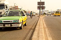
Kitaubani's transport network is diverse, with numerous methods available connecting settlements, the islands, and the country itself to the outside world. | Kitaubani's transport network is diverse, with numerous methods available connecting settlements, the islands, and the country itself to the outside world. The Kitauban rail network is relatively robust, including intercity service, freight transport, and urban light rail. | ||
{{Gallery | {{Gallery | ||
|title= | |title= | ||
| Line 201: | Line 206: | ||
|File:Ghetto, Lagos, Nigeria, 12-15-16h20m56s237.png | |File:Ghetto, Lagos, Nigeria, 12-15-16h20m56s237.png | ||
|alt3= | |alt3= | ||
| A collection of minibuses outside a train station in suburban | | A collection of minibuses outside a train station in suburban Mwera | ||
|File:ILORIN_TRAIN_STATION.jpg | |File:ILORIN_TRAIN_STATION.jpg | ||
|alt4= | |alt4= | ||
Latest revision as of 22:08, 17 June 2024
Kingdom of Kitaubani उफ़ल्मे व कितुओप्वनि (KiUngwana) Ufalme wa Kituopwani | |
|---|---|
 Flag
 Coat of arms
| |
| Motto: ऊमोज कतिक ऊतोफ़ौति Umoja katika Utofauti (KiUngwana) Unity in Diversity | |
| Anthem: "Alfarma" "Majesty" | |
| Capital | Kwamuimepe |
| Largest city | Kikambala |
| Official languages | KiUngwana |
| Recognised regional languages | Mwenye Chemwal |
| Ethnic groups (2023) | |
| Religion (2023) | List
|
| Demonym(s) | Kitauban |
| Government | Unitary constitutional monarchy |
• Queen | Majani I |
• Chancellor | Enzi Wario |
| Area | |
• | 259,786.24 km2 (100,304.03 sq mi) |
| Population | |
• 2023 estimate | 58,974,231 |
| GDP (nominal) | 2023 estimate |
• Total | $1,316,186,887,458 |
• Per capita | $22,318 |
| Currency | Kitauban paisa (₱) (KTP) |
| Time zone | UTC+3 (KST) |
| Date format | yyyy-mm-dd (VS) |
| Driving side | right |
| Calling code | +27 |
| Internet TLD | .kt .क्त् |
Kitaubani, known officially as the Kingdom of Kitaubani (KiUngwana: उफ़ल्मे व कितुओप्वनि, Ufalme wa Kituopwani), is a sovereign state located at the northern tip of XISLAND. The current population of 58,974,231 people is spread across XX square kilometers, making Kitaubani a country with population and density.
XISLAND was inhabited since ancient times by numerous groups, such as the Mijikenda and the Chemwal. These groups frequently associated with one another and with their cohorts on the !AFRICAN mainland through a cross-channel trade network. City-states were beginning to form on the coasts, which interfaced with the more nomadic groups in the hinterlands through trade, diplomatic marriage and warfare. These patterns of interaction were interrupted in the mid-eleventh century CE, when an Ungwana ruler known as Mataka fled warfare in his home territory. Mataka's arrival in Kitaubani presaged that of his followers, which included a significant merchant caste that soon dominated the city of Msua. For around a century, Msua operated indistinctly from other coastal Kitauban city-states. By the end of the twelfth century, however, Msua's Ungwana rulers had begun attacking neighboring city-states, either to annex them or force them into tributary status. This eventually transformed into the elite of Msua holding at least nominal control of most of the Kitauban islands by the 1600s. To this day, Mataka's initial takeover of the village of Msua is seen as the direct predecessor of the modern Kitauban state, and Mataka himself is considered in the popular consciousness as the first mfalme, or Ungwana ruler of Kitaubani.
Presently, the Kingdom of Kitaubani is ruled as a constitutional monarchy with the principle of parliamentary sovereignty. The government retains moderately low corruption and high transparency scores. It is a member of the Congress of Nations, X, Y and Z organizations. Kitaubani maintains one of the stronger economies in !AFRICA, benefiting from a growth in urban manufacturing and its influence in the global shipping industry.
Etymology
The name Kitaubani likely derives from a KiUngwana phrase, though it has been altered and simplified significantly after centuries of contact with numerous languages. Following a series of conflicts on mainland !AFRICA in the eleventh century CE, an expedition led by mfalme (Ungwana king) Mataka, landed on the shores of Kitaubani at the site of modern-day Msua. Mataka, likely a previously-impoverished noble, had fled his homeland both to escape violence at home and to re-establish his wealth through new economic holdings. After a long journey fraught with adverse conditions, conflicts with local authorities, and other innumerable hardships, was the island of Kitaubani: according to popular folklore, in his relief at completing his journey, Mataka proclaimed the site kituo wa pwani, or the Coast of Respite. As Mataka carries an almost-mythified status in Kitauban consciousness as one of the first kings of the island, this story has persisted and grown to be the most popular folk etymology for the name of the country. The name, before the establishment of the modern kingdom in the late 18th century, was traditionally associated with the entire coastal region.
History
The first settlers of Kitaubani likely crossed into the area from mainland !Africa via maritime crossings of the Ufa Channel.
Arrival of Mataka
[1050-1250 CE roughly, terminated by a brief foreign conquest?]
Second Msua Period
[1300-1556 CE]
Msumbiji Empire
The Second Msua Period is generally dated to end in 1556 CE, when the rulers of Msua were definitively subsumed into the growing entity known later to historians as the Msumbiji Empire. This date is not without problems, however; for at least two decades beforehand, the Msuan kings had been losing control of the fringes of their domain, as well as suffering from a prolonged spell of poor state finances. From their initial capital at Mwera, the WaMsumbiji pivoted away from a focus on dominating the inland trade routes of XISLAND and towards control of the coasts of the !INDIAN Ocean. Gradually, the Msumbiji came to dominate much of the coastline through a complex series of governing agreements known as the duera system, which allowed for significant territorial control, taxable revenue potential, and cultural diffusion at the cost of state decentralization and pronounced local autonomy. At the empire's territorial height in the 18th century, for example, X.
[1556-early 1800s]
Modern Kitaubani
[1800s-present]
Geography
Climate
The climate of Kitaubani is primarily influenced by the Ufa Channel, to the country's west, and the !INDIAN Ocean to its north and east. As a result, much of Kitaubani is classified as tropical savanna, tropical wetland or tropical monsoon climates on the Rajoelina climate classification scale; the only areas to be not labeled as tropical are the humid subtropical regions farther inland or the foothills to the very south of the country.
Administrative divisions
Kitaubani is subdivided into 22 departments, further subdivided into districts. These districts are centered around a significant autonomous settlement with a city council, with the remaining territory divided into wards overseen by municipal, village, or rural councils. The departments of Kitaubani were drawn for the most recent time in 1970, designed to roughly correspond to equal population size per district. Due to substantial industrialization and urbanization in the intervening decades, however, there now exists a substantial population disparity between rural and more urbanized departments.
Demographics
Ethnicity
Language
KiUngwana, as the language of the royal family and elite merchant caste, has for centuries served as the lingua franca of the empire. Education in the Ungwana language is mandatory across the nation, though provisions exist for schooling in regional languages.
Education
Religion

The state-sanctioned religion of Kitaubani is Dinism, a highly-syncretic Mokshaic faith based on adaptations of Vedistic tradition to local folk traditions. Despite state sanction and support dating back centuries, Kitaubani has been continually peopled by a diverse array of believers. Part of this religious diversity can be explained by the decentralized nature of Dinism; rather than a cohesive religion with a singular doctrine, the faith is defined by an array of priestly schools and community religious leaders, all interfacing with each other and with local ritual customs. Additionally, though the Kitauban Decennial Census of 2020 records XX% of the population follows a "traditional or folk religion," the line between the aforementioned and Dini practice is often blurry due to the latter's frequent coöpting of the former. Additionally, owing to the region's centuries-old role as a major trade entrepôt, numerous groups of people have migrated to the region, bringing their religions with them. In the interest of increased trade profits, successive governments of the Pwani Coast generally opted for a policy of religious tolerance. In the modern day, though they lack the protection and support of Dinism, other religions generally persist without persecution. Such religions include Manichaeism (the largest of this kind), X, and Y.
Government
,_against_blue_coloured_sky,_Mysuru,_Karnataka.jpg)
Kitaubani is a unitary constitutional monarchy, governed under its 1969 Constitution. The head of state is Queen Majani I. Under the Kitauban Constitution, the monarch holds authority as commander-in-chief of the armed forces and ultimate source of government authority. The monarch is provided a parliamentary head of government, known in KiUngwana as the Wakili wa Ikulu or palace steward (though typically, this term is translated as Chancellor). Currently, the Chancellor is Enzi Wario, an admiral and non-partisan. The Chancellor is typically elected from the ranks of Kitaubani's parliament, the National Assembly, with final approval granted via royal assent. Chancellors serve at the monarch's pleasure; the current Chancellor, Wario, was appointed without Assembly election by Queen Majani following the assassination of their predecessor, Mulele Kimachu, in February 2022.
Executive government functions in Kitaubani are channeled through a network of ministries, royal commissions and extra-ministerial bureaus that answer to the monarch through the Cabinet. The Chancellor exercises most of their authority as head of the Cabinet on behalf of the monarch for day-to-day operations. The monarch's guaranteed powers include, but are not limited to, the ability to finalize declarations of war, treaties, and international agreements; the ability to appoint and dismiss executive government officers; the ability to appoint judges; and the ability to reject draft laws from the National Assembly (aside from proposed budgets, which falls under the purview of the National Assembly). The monarch traditionally rules from Tai Mweusi Palace in central Kwamuimepe, established during Msumbiji times as a summer palace and featuring distinctly !SOUTHINDIAN architecture.
Legislative functions of the Kitauban government are housed under the National Assembly, the nation's bicameral parliament. The lower house, elected through universal suffrage, is known as the Chamber of Representatives; the upper house is known as the Chamber of Peers and is comprised of hereditary appointments by the monarch and the noble leaders from various regions of the country. The National Assembly remains primarily the playground of the Kitauban elite.
Law
The Kingdom's laws are a mixture of several iterations of codified civil law and religious law based on the state religion, Dinism. The judiciary of Kitaubani, according to the Constitution, exists in subordination to the monarch (judges are selected by a committee of legal experts and approved by the monarch).
The Kitauban Constitution provides a limited set of rights guaranteed to Kitauban subjects. These include:
- The right to petition the government,
- The right to unobstructed movement within Kitaubani,
- The freedom to own private property, unless conflicting with overriding national interest,
- The sanctity of home and property against search and seizure, unless conflicting with overriding public safety interest,
Other rights are provided more conditionally, and are subject to revocation under royal prerogative.
In exchange for these rights, Kitauban subjects are obliged by the constitution to pay tax, serve in the military when called, and uphold the laws of Kitaubani. Additionally, the Constitution formally abolished the old Kitauban caste system, though social discrimination based on the caste system continues to this day.
Foreign relations
The foreign policy of the Kitauban state is dominated by two competing schools of thought. The first, known colloquially to outside observers as the "blue-water school," prioritizes economic and political relationships in the !INDIAN Ocean, up to and including dominance of the coastline either through political control or imperial influence. Proponents of the blue-water school point to the thalassocratic Msumbiji Empire, which at its peak in the 18th century controlled much of the Ocean's coasts either directly or through mercantile agreements, as a model to emulate in the future. The most vocal proponents of blue-water foreign policy in the Kitauban government come from descendants of the nation's wealthiest merchant families and the Royal Kitauban Navy top brass; the two groups share a significant overlap in membership. In contrast, the so-called "brown-water school" consists of those elites, often from minority ethnic groups, with little connection to the overseas trade industry, and is associated with the Royal Kitauban Army. In contrast to the blue-water policy proponents, advocates of brown-water policy champion prioritizing relations with states in !Africa and on XISLAND, especially focusing on the Ufa Channel.
As a result of blue-water school influence, Kitaubani maintains developed relations with the Ngāti Onekawa-Nukanoa.
Economy
Kitaubani is classified as a higher-middle-income nation, with a Gross Domestic Product (GDP) per capita of $22,318, for a total value of $1,316,186,887,458 as of 2023. With only a moderate industrial base of its own, the Kitauban economy is primarily driven by shipping, finance, trade, and specialized agriculture. What industry does exist consists largely of processing local and imported raw materials, like coffee, tea, and spices, and small-scale shipbuilding. A notable exception, beginning in the 2000s, is a small yet burgeoning trade in manufacturing integrated circuit chips for use in electronics.
Transportation
Kitaubani's transport network is diverse, with numerous methods available connecting settlements, the islands, and the country itself to the outside world. The Kitauban rail network is relatively robust, including intercity service, freight transport, and urban light rail.

A passenger rail service bound for Kwamuimepe in central Kitaubani

Airliners at Kwamuimepe Airport

A collection of minibuses outside a train station in suburban Mwera
A suburban Kitauban highway

A Kitauban-flagged oil tanker underway

A tram on the Kwamuimepe Light Rail network


