Yocopo (state): Difference between revisions
No edit summary |
No edit summary |
||
| (29 intermediate revisions by the same user not shown) | |||
| Line 1: | Line 1: | ||
[[Category:Yogania]] | [[Category:Yogania]] [[Category:States of Yogania]] | ||
{{Infobox settlement | {{Infobox settlement | ||
|name = Yocopo | |name = Yocopo | ||
|native_name = <!-- Settlement name in local language(s), if different from the English name --> | |native_name = <!-- Settlement name in local language(s), if different from the English name --> ''Golorden bul Yocopo'' (Buggan) <br> ''Yocopo Bucharyod'' (Kjerso) <br> ''État de Yocopo'' (French) | ||
|native_name_lang = <!-- ISO 639-1 code e.g. "fr" for French. If more than one, use {{lang}} instead --> | |native_name_lang = <!-- ISO 639-1 code e.g. "fr" for French. If more than one, use {{lang}} instead --> | ||
|settlement_type = State | |settlement_type = State | ||
| Line 14: | Line 14: | ||
|image_seal = | |image_seal = | ||
|seal_alt = | |seal_alt = | ||
|image_shield = | |image_shield = [[File:Yocopocofa.jpg|150px|frameless|center]] | ||
|shield_alt = | |shield_alt = | ||
|etymology = | |etymology = | ||
|nickname = | |nickname = | ||
|motto = | |motto = | ||
|image_map = {{Switcher|[[File:Yocopostatelocation.jpg| | |image_map = {{Switcher|[[File:Yocopostatelocation.jpg|300px|frameless|center]]|Show Yocopo's location in Yogania| | ||
[[File:Yocopostatemap.jpg| | [[File:Yocopostatemap.jpg|300px|frameless|center]]|Show map of Yocopo|default=1}} | ||
|map_alt = | |map_alt = | ||
|map_caption = | |map_caption = | ||
| Line 34: | Line 34: | ||
|subdivision_name = [[Yogania]] | |subdivision_name = [[Yogania]] | ||
|subdivision_type1 = Region | |subdivision_type1 = Region | ||
|subdivision_name1 = Bukjer | |subdivision_name1 = [[Bukjer]] | ||
|subdivision_type2 = Capital | |subdivision_type2 = Capital city | ||
|subdivision_name2 = [[Yocopo (city) | |subdivision_name2 = [[Yocopo (city)]] | ||
|subdivision_type3 = | |subdivision_type3 = | ||
|subdivision_name3 = | |subdivision_name3 = | ||
| Line 52: | Line 52: | ||
|leader_title1 = Assistant Governor | |leader_title1 = Assistant Governor | ||
|leader_name1 = Gregory Yodolric | |leader_name1 = Gregory Yodolric | ||
|leader_title2 = | |leader_title2 = President of state council | ||
|leader_name2 = | |leader_name2 = Yorgon Jakobson | ||
|leader_title3 = | |leader_title3 = | ||
|leader_name3 = | |leader_name3 = | ||
| Line 114: | Line 114: | ||
}} | }} | ||
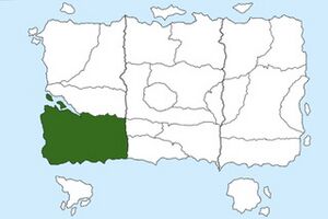
'''Yocopo''' is one of the 22 states of [[Yogania]]. It is located in the south of the region of Bukjer, in the west of the island. It is the fourth most populous state with 64 million inhabitants. The capital and largest city of the state is [[Yocopo (city)|Yocopo]], which is also the capital and largest city in Yogania with it´s 34 million inhabitants. The state of Yocopo is defined by it's long coastlines at the south and southwest, the Borogel mountains at the northwest, and part of the Burnach plain at the south. It is dominated by the Koldrigin plain, spanning 50% of the state's land and containing many of it´s amjor cities. It is Yogania´s only officially trilingual state, with Buggan Yoganian, Kjerso Yoganian, and French as it´s official languages though most of the population speak French. | |||
==Etymology== | |||
The state of Yocopo was named after it´s capital city, [[Yocopo (city)|Yocopo]], which comes from a combination of the name Yogodan, referring to Yogodan I the Great, first [[King of Yogania]], and the Old Yoganian word ''Kopol'', meaning city or town. | |||
==Geography== | |||
===Physical Geography=== | |||
Yocopo's territory is mainly flat except for part of the Borogel mountain chain at the northwest of the state. It is dominated by the Koldrigin plain spanning through the center, north and west and part of the Burnach plain at the east. The main water source is the Yocopo river coming from the Borogellin Gulf and discharges in the Yoganian Sea in the south. Yocopo is also covered by part of the Goylar forest in the northeast. | |||
===Administrative Geography=== | |||
Yocopo is located in south-western [[Yogania]], in the region of Bukjer. It is bordered by the state of Ordansk at the north and the states of Oodos and Burnach at the east. It is also only 100 kilometers away from the neighboring island state of Bugareyol. | |||
===Subdivisions=== | |||
[[File:Yocopodistricts.jpg|200px|thumb|right|District map of Yocopo.]] | |||
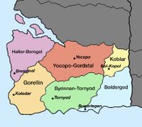
Yocopo is divided into 7 districts, from most to least populous; Yocopo-Gordstal, Bolderged, Halter-Borogel, Byrinnen-Tornyod, Gorellin, and Koblar. The most populous, Yocopo-Gordstal, contains more than half of the state's population with over 38 million inhabitants (2022). | |||
==Demographics== | |||
===Population=== | |||
According to the 2022 population census conducted by the [[Yoganian Statistics Institute]] (YSI), the total population of the state of Yocopo is of 64,441,782 million inhabitants, an increase of 10,2 % compared to the 2012 population census. | |||
===Cities=== | |||
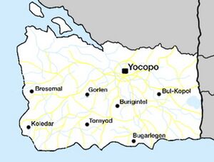
81% of the Yocopo population live in cities according to the [[Yoganian Statistics Institute|YSI]]. The capital and largest city of Yocopo is [[Yocopo (city)|the city of the same name]], with 34,895,142 million inhabitants, more than half of the state's total population. Cities in Yocopo are mainly concentrated around the capital or the coastlines, with few exceptions. | |||
{| class="wikitable sortable" | |||
|+ Largest cities in Yocopo by population | |||
|- | |||
! Rank !! City !! Population !! District | |||
|- | |||
| 1 || [[Yocopo (city)|Yocopo]] (capital) || 34,895,142 || Yocopo-Gordstal | |||
|- | |||
| 2 || Gorlen || 3,675,102 || Yocopo-Gordstal | |||
|- | |||
| 3 || [[Bugarlegen]] || 1,034,542 || Bolderged | |||
|- | |||
| 4 || Bresemal || 987,420 || Halter-Borogel | |||
|- | |||
| 5 || Koledar || 534,851 || Gorellin | |||
|} | |||
Latest revision as of 12:04, 13 August 2024
Yocopo
Golorden bul Yocopo (Buggan) Yocopo Bucharyod (Kjerso) État de Yocopo (French) | |
|---|---|
State | |
| Country | Yogania |
| Region | Bukjer |
| Capital city | Yocopo (city) |
| Established | 1799 |
| Government | |
| • Type | State government |
| • Governor | Yogory Bobian |
| • Assistant Governor | Gregory Yodolric |
| • President of state council | Yorgon Jakobson |
| Area | |
| • State | 501,269 km2 (193,541 sq mi) |
| • Land | 493,660 km2 (190,600 sq mi) |
| • Water | 7,609 km2 (2,938 sq mi) |
| • Urban | 233,724 km2 (90,241 sq mi) |
| • Rural | 267,545 km2 (103,300 sq mi) |
| Population | |
| • State | 64,441,782 |
| • Density | 130/km2 (330/sq mi) |
| Time zone | UTC -2, -1, 0 |
| Area codes | 10-19 |
| Website | www.yogorydgovernar.yo |
Yocopo is one of the 22 states of Yogania. It is located in the south of the region of Bukjer, in the west of the island. It is the fourth most populous state with 64 million inhabitants. The capital and largest city of the state is Yocopo, which is also the capital and largest city in Yogania with it´s 34 million inhabitants. The state of Yocopo is defined by it's long coastlines at the south and southwest, the Borogel mountains at the northwest, and part of the Burnach plain at the south. It is dominated by the Koldrigin plain, spanning 50% of the state's land and containing many of it´s amjor cities. It is Yogania´s only officially trilingual state, with Buggan Yoganian, Kjerso Yoganian, and French as it´s official languages though most of the population speak French.
Etymology
The state of Yocopo was named after it´s capital city, Yocopo, which comes from a combination of the name Yogodan, referring to Yogodan I the Great, first King of Yogania, and the Old Yoganian word Kopol, meaning city or town.
Geography
Physical Geography
Yocopo's territory is mainly flat except for part of the Borogel mountain chain at the northwest of the state. It is dominated by the Koldrigin plain spanning through the center, north and west and part of the Burnach plain at the east. The main water source is the Yocopo river coming from the Borogellin Gulf and discharges in the Yoganian Sea in the south. Yocopo is also covered by part of the Goylar forest in the northeast.
Administrative Geography
Yocopo is located in south-western Yogania, in the region of Bukjer. It is bordered by the state of Ordansk at the north and the states of Oodos and Burnach at the east. It is also only 100 kilometers away from the neighboring island state of Bugareyol.
Subdivisions
Yocopo is divided into 7 districts, from most to least populous; Yocopo-Gordstal, Bolderged, Halter-Borogel, Byrinnen-Tornyod, Gorellin, and Koblar. The most populous, Yocopo-Gordstal, contains more than half of the state's population with over 38 million inhabitants (2022).
Demographics
Population
According to the 2022 population census conducted by the Yoganian Statistics Institute (YSI), the total population of the state of Yocopo is of 64,441,782 million inhabitants, an increase of 10,2 % compared to the 2012 population census.
Cities
81% of the Yocopo population live in cities according to the YSI. The capital and largest city of Yocopo is the city of the same name, with 34,895,142 million inhabitants, more than half of the state's total population. Cities in Yocopo are mainly concentrated around the capital or the coastlines, with few exceptions.
| Rank | City | Population | District |
|---|---|---|---|
| 1 | Yocopo (capital) | 34,895,142 | Yocopo-Gordstal |
| 2 | Gorlen | 3,675,102 | Yocopo-Gordstal |
| 3 | Bugarlegen | 1,034,542 | Bolderged |
| 4 | Bresemal | 987,420 | Halter-Borogel |
| 5 | Koledar | 534,851 | Gorellin |


