Gregahou: Difference between revisions
No edit summary |
No edit summary |
||
| Line 307: | Line 307: | ||
Gregahou has a population of 3,565,772 according to the 2018 national census, growing by almost 1 million since the turn of the century. Gregahou is the 4th most populous country in the Caribbean Community and the most populous inhabited area in the Sargasso Sea as well as in the grouping of Atlantic islands. The country has a population density of 454 inhabitants per square kilometer (1,175.6 per square mile). Over 80% of the country's residents live in urban areas, with Stolitsemlağa, Almata, and Azğa being the most populated, and all major urbanized areas with the exception of Onel as well Molina in the Porte Nouvelle protectorate are oceanfront settlements. Interior areas on the 6 islands are sparsely inhabited. | Gregahou has a population of 3,565,772 according to the 2018 national census, growing by almost 1 million since the turn of the century. Gregahou is the 4th most populous country in the Caribbean Community and the most populous inhabited area in the Sargasso Sea as well as in the grouping of Atlantic islands. The country has a population density of 454 inhabitants per square kilometer (1,175.6 per square mile). Over 80% of the country's residents live in urban areas, with Stolitsemlağa, Almata, and Azğa being the most populated, and all major urbanized areas with the exception of Onel as well Molina in the Porte Nouvelle protectorate are oceanfront settlements. Interior areas on the 6 islands are sparsely inhabited. | ||
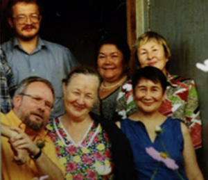
[[File:GregahouFamily.png|right|thumb|A typical Gregahouvian family may consist of multiple ethnic groups given the settlement history of the nation]] | |||
The country has a diverse population; 55.7% of the population is registered as Tatar, and 22.9% Chechen, but almost all of the remaining people are equally proportioned to other groups, including Bashkir, Turkmen, Gagauz, Chuvash, Avar, Ossetian and others. First settlers were presumed to have been almost all Tatar, but family records show that Bashkir, Chuvash, Turkmen, and Chechen people must have been present in Gregahou as early as 1968. The Gregahouvian census reports people from ethnic groups with a significant number present at the time of the first census as "ethnically Gregahouvian" for documentation purposes. As per the 2018 census, 93.2% of residents were classified as ethnically Gregahouvian, leaving the remaining 6.8% to the immigrant population. Immigration to Gregahou is not common, in a large part due to the country's strict immigration laws. However, due to the large amount of ethnic groups present as well as the liberal usage of English on road signs and government documents, English-speaking immigrants and visitors generally do not meet much trouble upon entry. Other than the 6.8% of immigrants in the 2018 population, the nation is by-choice less worldly than most of its Caribbean counterparts. | |||
===Language=== | |||
Gregahouvian is the only national language, but both Gregahouvian and English are designated as official languages by the government, and government documents and legislature is written in both Gregahouvian and English. Additionally, French is recognized as a regional official language in the Porte Nouvelle protectorate, and legislature, government documents, and information on nationally-owned property is written there in French and Gregaouvian, as required by law. Gregahouvian is the sole national language, but Gregahou's 9 major ethnic groups speak over 10 languages at home, found in a 2012 study from the nation's National University. Despite the wide distribution of ethnic groups, and subsequently the wide distribution of languages, the Gregahouvian language is homogenous throughout the different groups of people. Mixing aspects of Russian, Tatar, Bashkir, Chechen, and Turkmen, but using Russian and Turkmen grammatical structure and a Latin-based script, the nation's official language is often looked at as a compound language and thus a dialect of sorts within multiple languages, but as a language which functions primarily as its own. | |||
Notably, most older Gregahouvians also are fluent in the [[Russian language]], but the majority do not use it at home or in public. In the 2018 census, 85% of the reported population noted that Gregahouvian was primarily used at home, while some 9% reported that another language was used. Only 6% reported that Russian was used primarily in the household, and a 2012 university study on Russian-speaking students found that Russian was only commonly used between parents and children in the home, not between friends or in public. | |||
===Population distribution=== | ===Population distribution=== | ||
Gregahou is a highly urbanized country, with a large number of towns and cities spread across the nation's six islands. The largest city is the nation's capital, [[Stolitsemlağa]], with a population of 1,598,937 within the urban area, and is the only city to surpass a population of one million. Other major urban areas include [[Almata]], with a population of just | Gregahou is a highly urbanized country, with a large number of towns and cities spread across the nation's six islands. The largest city is the nation's capital, [[Stolitsemlağa]], with a population of 1,598,937 within the urban area, and is the only city to surpass a population of one million. Other major urban areas include [[Almata]] and Molina, with respective populations of around 950,000, and Cialtina, with a population of just over 300,000 residents. | ||
{{Largest cities | {{Largest cities | ||
| Line 331: | Line 341: | ||
{{Template reference list}} | {{Template reference list}} | ||
</noinclude> | </noinclude> | ||
===Religion=== | ===Religion=== | ||
Revision as of 23:47, 10 February 2020
This article is incomplete because it is pending further input from participants, or it is a work-in-progress by one author. Please comment on this article's talk page to share your input, comments and questions. Note: To contribute to this article, you may need to seek help from the author(s) of this page. |
Commonwealth of Greğahou Sodruz Greğahouğanskiy | |
|---|---|
| Motto: Ot tsakasa prikhodit şvoboda (Gregahouvian) "From order comes freedom" | |
| Anthem: Natsionalniy "The National" | |
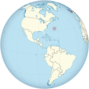 Location of Gregahou (red) in the Western Hemisphere | |
| Capital and largest city | Stolitsemlağa |
| Official languages | Gregahouvian English |
| Recognised regional languages | French (in Porte Nouvelle) |
| Ethnic groups (2016) | 57.7% Tatar 22.9% Chechen 4.3% Turkmen 3.8% Bashkir 11.3% others |
| Demonym(s) | Gregahouvian |
| Government | Unitary presidential republic |
• President | Imat Ilva (SD) |
• Prime Minister | Yohan Varayev (NL) |
| Legislature | Zdaniye Parlamentiy |
| Sobraniy Natsional | |
| Sobraniy Publiçniy | |
| Independence from the Soviet Union | |
• Declaration | May 3, 1981 |
• Establishment as sovereign | May 12, 1981 |
• Establishment as Gregahou | July 2, 1981 |
| Area | |
• Total | 7,798 km2 (3,011 sq mi) |
| Population | |
• 2018 estimate | 3,565,772 (129th) |
• Density | 453.9/km2 (1,175.6/sq mi) |
| GDP (PPP) | estimate |
• Total | 13,323 (in US$ millions) |
• Per capita | $15,989 |
| Gini (2016) | medium (31st) |
| HDI (2018) | very high (35th) |
| Currency | Kadz (₭) (KDZ) |
| Time zone | UTC-4 (AST) |
| Date format | dd/mm/yyyy |
| Driving side | right |
| Calling code | +522 |
| ISO 3166 code | GO |
| Internet TLD | .go |
Gregahou (pronounced /greɪjɑhu/), officially the Commonwealth of Gregahou (Gregahouvian: Sodruz Greğahouğanskiy) is a small island nation located in the Atlantic Ocean, approximately 1,100 km due east of Buxton, North Carolina; 1,250 km due south of Nova Scotia; and 1,780 km north-east of Cuba. Though typically referred to in the singular, the nation's landmass of 7,798 square kilometers (3,010 square miles) is separated between 6 islands, including its one sovereign protectorate, Porte Nouvelle. With an estimated population of 3,565,772, Gregahou is the 129th most populous country. The capital city is Stolitsemlağa, and, as the nation's largest city, it functions as the cultural center of Gregahou. Other large major urban areas include Almata, Azğa, Onēl, as well as Molina in Porte Nouvelle.
Gregahou is a developed country, and in terms of GDP, the nation ranks only below Jamaica in the Caribbean Community. The Gregahouvian economy is regarded as a social market economy, and focuses mainly on the export of oil as well as having a stake in offshore international financial services. Despite being classified by some as a tax haven, the government does a statistically remarkable job at separating the desires of foreign investors from the nation's own notably poorer population, and as thus, Gregahou enjoys a rating of 68 on the Corruption Perceptions Index.
Russian oil giant Tatneft ordered the construction of an oil rig off the coast of the country's largest island, then uninhabited, in 1954, and colonization began in 1955. Numerous disputes between workers sent to the colony and Tatneft in addition to a lack of strong government presence in the archipelago led to a war for independence lasting between 1972 and May of 1981, when electricity was shut off to the final operational oil rig. By 1981, the colony was fully modernized, but lack of funding proved difficult for progress in early independent Gregahou, and the country emerged from its war for independence in poverty.
History
Main article: Gregahouvian War for Independence
Until 1954, the archipelago remained uninhabited as a jointly-monitored nature sanctuary by the United States, the Soviet Union and France. However, throughout the immediate postwar period in the late 1940s to early 50s, the archipelago became less important to the United States and control was split between the latter two administrators. France elected to focus their resources on the easternmost island of Porte Nouvelle while rule over the five main islands was left to the Soviet Union. Throughout the end of the 1940s and the early 1950s, the archipelago was frequently visited by researchers studying the endemic flora and fauna of the Western Atlantic ecoregion, the other landmass of Bermuda being previously colonized and introduced to foreign species on a large scale. Due to the archipelago's generally agreeable climate, invasion rate of introduced foreign species is extremely high, and measures were put in place to restrict visitors to the island. Still, in 2019, despite the introduction of many invasive species, Gregahou continues to hold one of the world's strictest criteria for entry, with random searches at airports and ferry terminals sometimes reaching to 50% of foreign passport holders and 100% of returning nationals.
Early history
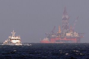
In December of 1953, Soviet researchers studying the endemic storm petrel found a petroleum seep on what is now Ostrov Stolitsa (English: Capital Island). As the archipelago was under complete Soviet control at the time, the government ordered oil conglomerate Tatneft to begin the construction of an oil rig called the Novyy Mira off the coast of present-day Stolitsemlağa and begin drilling. In January of 1954, 250 men, mostly from the Tatarstan region of Russia, arrived on boats to begin the construction of a shipyard and airfield in what is now the central business district of the nation's capital. The shipyard has since been renovated but original pier and dock locations and some original materials still remain. With increased ease of transport to the island, in March of 1954, construction started on both the oil rig as well as housing for the increasing number of staff on the island, which, by March, had risen to approximately 400.
The first oil rig began service in October of 1954, and with the increased number of people living full-time on the island, more resources were pushed towards funding a proper settlement for the inhabitants. Construction on a block of apartments began in January 1955, and by summer of the same year, 10 fully functional apartment blocks were constructed, housing 400+ new residents and named Rezidentsiya-1. Out of the original 10 buildings of 12 stories each, 5 still stand on the coast of Stolitsemlağa's Tsentralniy Rayon. The new neighborhood retained its Romanized name of Rezidentsiya-1 after independence, not the correct Gregahouvian Rezidentsiğa-1, non-conforming to language standards.
Expansion and industrialization
The first Tatneft project proved to be less successful than originally thought, and within two years of operation, the company began looking around the archipelago for additional potential drill sites. In December of 1956, a second deposit was found approximately 15 miles west of the largest island. Construction on this second rig, to be named Almetyevska, began in February of 1957, and a second shipyard, airfield and settlement also began construction near what is now the nation's second largest city, Almata. By August 1957, both oil rigs were fully operational.
The Almetyevska rig found Tatneft more success than its first foray, but an expansion project was ordered on the smaller island to form an incorporated settlement, named Gorod-1, or City 1 where the present-day capital stands today. Most speculate this might have been ordered to compete with the rapidly-modernizing Porte Nouvelle, wherein the French had constructed a military base in the summer of 1956.
By 1960, population of the archipelago had risen to almost 5,000, and year-round stay was common for Tatneft employees and their families by the turn of the new decade. Most of the settlement's residents still resided in Gorod-1 and usually commuted to the second oil rig daily or weekly for shifts, and, in 1961, the first consumer vehicles and trolley buses were present in the settlement. Starting in 1963, public ferry service commenced between the two settlements, and, in June of the same year, the Almetyevsk rig's production numbers gave way to a second incorporated settlement, Gorod-2.
Growing tensions
In 1964, population growth on the islands shifted from new oil rig workers to building petrochemical plants and the production of petrochemical products. Situated east of the second settlement in the hills, most of the plants functioned as refineries, but also to produce petrochemicals, most notably polyvinyl chloride. With the opening of three new production sites, population on the islands rose to surpass 10,000. Into the late 1960s, infrastructure started to wear under the use of more than 10,000 people, and the quality of life in the settlements decreased drastically, mainly due to the settlements' poor build quality.
First recorded protests began in 1965 or 1966, but conflicting reports still leave some information unknown. In December of 1966, oil rig operator Griegor Antonyev submitted the first official proposal to Tatneft for change in operation and quality of life, but the memorandum was quickly shot down. Public protests began in the two largest cities shortly afterwards, and increased police presence was then sent to the island. In 1969, another protest group approached the governing body in search of solution. By then, the settlements functioned as legitimate cities however without stable government, and, due to the archipelago's isolation, cost of living and wages were extremely mismatched. The growing movement against Tatneft, after receiving another silent response, decided to conduct the first strike on the company in July of 1969.
Largely successful due to the closely-knit community between residences, Tatneft succumbed to the group's request, and eventually raised wages and imposed price controls on their company-run supermarkets and other businesses. However, by September of 1969, prices had again risen, and Antonyev's group organized another strike. The second time, however, Tatneft immediately let go over 60 of their employees involved with the strike. The group remained active within the organization despite the strict decision, and word on the company's future action was easily passed onto the original protesters, who became more militant in their methods. Self-proclaimed as Naşa Ludiy (English: Our People), the group began to disrupt business and work procedures for Tatneft by trespassing and breaking equipment, damaging company vehicles in cities, and on four occasions, set fire to Tatneft-owned buildings.
By the end of the 1960s, however, the Soviet Union had begun to invest more money into their territory, and the acts of violence from Naşa Ludiy did not go unnoticed. A military post was placed near Gorod-1 in October of 1969 and, due to instability on the islands and lack of governing body, secret police and plainclothes officers began to patrol the cities and guard Tatneft facilities. The presence forced tensions to calm, but the islanders became more distrusting of the government and of Tatneft, still where over 80% of residents worked.
Geography
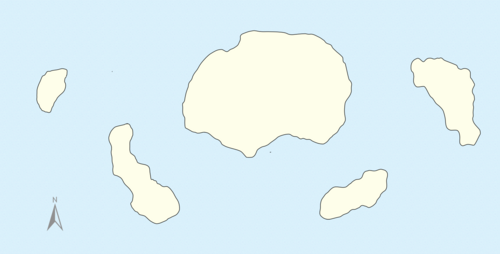
The archipelago is a series of low forming volcanoes in the Atlantic Ocean, on the western edge of the Sargasso Sea. Ostrov Novağa-Zemliğa is the largest island of the archipelago, and notably the most rugged in terrain, containing the nation's highest peak at Velağa-Gora (English: White Mountain). Other than on the largest island, the terrain is relatively low-lying and flat, with the second highest peak at just 191m (626ft). The most populous island is Ostrov Stolitsa, which, with over 1 million inhabitants, represents over one-third of the country's total population. Together with Bermuda, the limestone islands make up the Western Atlantic ecoregion, with the Gregahouvian archipelago being the most populated part of the region.
Climate
Gregahou has a humid subtropical climate (Köppen climate classification: Cfa), and is warmed by the Gulf Stream and relatively low latitude. The archipelago usually experiences cooler temperatures in the winter months, and temperatures in January generally average 17°C (63°F). However, there has never been a snowfall or freeze on record in Gregahou, even at its highest peak. In the summer months, temperatures rise considerably, but daily highs usually do not exceed 29°C (85°F). In August, at the peak of summer, ocean water temperatures at the beaches in the country's capital average 28°C (82°F), and are usually slightly cooler in the country's northernmost coast.
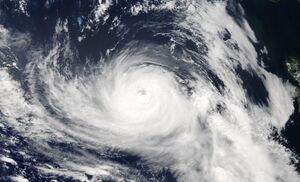
The archipelago is in the hurricane belt, and is often in the direct path of hurricanes as they begin to reach the westerlies, but direct landfall is rare due to the common nature of hurricanes to curve northward and weaken before direct landfall on North America. Additionally, the archipelago's small size means that direct hits are very uncommon.
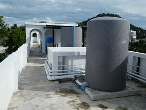
As the archipelago has no freshwater rivers or lakes, the only source of fresh water is rainfall, which is collected for consumption using roof gutters and catches and is stored in tanks usually either in the house's foundation or on the roof. Every residence is required by national law to have at least one tank piping rainwater down from the roof of the building. Rainfall is generally highest in fall, with monthly averages peaking in October.
Flora and fauna
Until the 1950s, the archipelago was uninhabited and mostly overrun with forests. Because of its isolation in the Atlantic Ocean, Gregahou is home to an interesting array of native flora, including the Bermuda cedar, which is endemic to the ecoregion, as well as fourteen other species of plants. Due to its semi-tropical climate, new flora were easily introduced by the islands' first settlers, and currently, much of the country's fruit supply is grown nationally. Palm trees, while not originally native to the islands, also now grow very commonly and are often used decoratively.
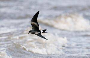
Endemic fauna is limited to a species of petrel, the storm petrel, Gregahou's national bird, but other indigenous animals include 3 species of bats: Lasionycteris noctivagans, Lasiurus borealis, and Perimyotis subflavus, all of which are also found in Bermuda as well as throughout the eastern United States. The storm petrel reached the IUCN Red List as an endangered species in 2003, and conservation efforts have raised populations, changing its classification again to vulnerable in 2014, only 11 years after conservation began. With the introduction of common domesticated animals such as cats and dogs onto the island, endemic bat populations have decreased but not enough to attract the attention of the IUCN. Common farm animals such as cows, chickens, and pigs do exist on the archipelago albeit in small quantities due to the nation's lack of arable land.
| Climate data for Stolitsemlağa – capital of Greğahou (National Airport) 2000–2015, extremes 1985–2015 | |||||||||||||
|---|---|---|---|---|---|---|---|---|---|---|---|---|---|
| Month | Jan | Feb | Mar | Apr | May | Jun | Jul | Aug | Sep | Oct | Nov | Dec | Year |
| Record high °C (°F) | 25.4 (77.7) |
25.7 (78.2) |
25.9 (78.6) |
27.2 (81.0) |
27.8 (82.0) |
30.9 (87.6) |
31.6 (88.8) |
33.4 (92.1) |
31.6 (88.9) |
29.7 (85.4) |
28.3 (83.0) |
26.8 (80.3) |
33.4 (92.1) |
| Average high °C (°F) | 20.2 (68.3) |
19.8 (67.7) |
20.2 (68.4) |
21.9 (71.5) |
23.5 (74.3) |
26.7 (80.1) |
29.4 (84.9) |
30.1 (86.2) |
29.3 (84.7) |
26.7 (80.1) |
24.7 (76.4) |
21.8 (71.2) |
24.3 (75.7) |
| Daily mean °C (°F) | 16.8 (62.2) |
16.3 (61.4) |
17.2 (63.0) |
18.7 (65.6) |
21.4 (70.5) |
23.3 (73.9) |
25.0 (77.0) |
26.5 (79.7) |
26.1 (78.9) |
23.4 (74.2) |
20.5 (68.9) |
18.0 (64.4) |
22.3 (72.2) |
| Average low °C (°F) | 14.7 (58.4) |
14.3 (57.7) |
15.4 (59.8) |
16.3 (61.3) |
19.2 (66.5) |
21.7 (71.0) |
24.3 (75.8) |
24.6 (76.2) |
24.5 (76.1) |
21.8 (71.2) |
18.7 (65.7) |
16.1 (61.0) |
19.4 (66.9) |
| Record low °C (°F) | 6.0 (42.8) |
5.5 (41.9) |
7.2 (45.0) |
8.4 (47.1) |
11.0 (51.8) |
14.1 (57.4) |
16.1 (61.0) |
19.7 (67.5) |
19.4 (67.0) |
13.9 (57.0) |
11.8 (53.3) |
8.6 (47.4) |
6.3 (43.3) |
| Average precipitation mm (inches) | 139 (5.47) |
124 (4.87) |
120 (4.72) |
106 (4.17) |
89 (3.52) |
120 (4.71) |
132 (5.21) |
162 (6.38) |
129 (5.09) |
160 (6.31) |
99 (3.88) |
110 (4.33) |
1,490 (58.66) |
| Average precipitation days (≥ 0.01 inch) | 18 | 16 | 16 | 12 | 10 | 11 | 13 | 15 | 14 | 15 | 14 | 15 | 169 |
| Average relative humidity (%) | 73 | 73 | 73 | 74 | 79 | 81 | 80 | 79 | 77 | 74 | 72 | 72 | 76 |
| Mean monthly sunshine hours | 142.9 | 144.5 | 185.7 | 228.1 | 248.1 | 257.2 | 281.0 | 274.1 | 220.1 | 197.5 | 170.3 | 142.5 | 2,492 |
Demographics
Gregahou has a population of 3,565,772 according to the 2018 national census, growing by almost 1 million since the turn of the century. Gregahou is the 4th most populous country in the Caribbean Community and the most populous inhabited area in the Sargasso Sea as well as in the grouping of Atlantic islands. The country has a population density of 454 inhabitants per square kilometer (1,175.6 per square mile). Over 80% of the country's residents live in urban areas, with Stolitsemlağa, Almata, and Azğa being the most populated, and all major urbanized areas with the exception of Onel as well Molina in the Porte Nouvelle protectorate are oceanfront settlements. Interior areas on the 6 islands are sparsely inhabited.
The country has a diverse population; 55.7% of the population is registered as Tatar, and 22.9% Chechen, but almost all of the remaining people are equally proportioned to other groups, including Bashkir, Turkmen, Gagauz, Chuvash, Avar, Ossetian and others. First settlers were presumed to have been almost all Tatar, but family records show that Bashkir, Chuvash, Turkmen, and Chechen people must have been present in Gregahou as early as 1968. The Gregahouvian census reports people from ethnic groups with a significant number present at the time of the first census as "ethnically Gregahouvian" for documentation purposes. As per the 2018 census, 93.2% of residents were classified as ethnically Gregahouvian, leaving the remaining 6.8% to the immigrant population. Immigration to Gregahou is not common, in a large part due to the country's strict immigration laws. However, due to the large amount of ethnic groups present as well as the liberal usage of English on road signs and government documents, English-speaking immigrants and visitors generally do not meet much trouble upon entry. Other than the 6.8% of immigrants in the 2018 population, the nation is by-choice less worldly than most of its Caribbean counterparts.
Language
Gregahouvian is the only national language, but both Gregahouvian and English are designated as official languages by the government, and government documents and legislature is written in both Gregahouvian and English. Additionally, French is recognized as a regional official language in the Porte Nouvelle protectorate, and legislature, government documents, and information on nationally-owned property is written there in French and Gregaouvian, as required by law. Gregahouvian is the sole national language, but Gregahou's 9 major ethnic groups speak over 10 languages at home, found in a 2012 study from the nation's National University. Despite the wide distribution of ethnic groups, and subsequently the wide distribution of languages, the Gregahouvian language is homogenous throughout the different groups of people. Mixing aspects of Russian, Tatar, Bashkir, Chechen, and Turkmen, but using Russian and Turkmen grammatical structure and a Latin-based script, the nation's official language is often looked at as a compound language and thus a dialect of sorts within multiple languages, but as a language which functions primarily as its own.
Notably, most older Gregahouvians also are fluent in the Russian language, but the majority do not use it at home or in public. In the 2018 census, 85% of the reported population noted that Gregahouvian was primarily used at home, while some 9% reported that another language was used. Only 6% reported that Russian was used primarily in the household, and a 2012 university study on Russian-speaking students found that Russian was only commonly used between parents and children in the home, not between friends or in public.
Population distribution
Gregahou is a highly urbanized country, with a large number of towns and cities spread across the nation's six islands. The largest city is the nation's capital, Stolitsemlağa, with a population of 1,598,937 within the urban area, and is the only city to surpass a population of one million. Other major urban areas include Almata and Molina, with respective populations of around 950,000, and Cialtina, with a population of just over 300,000 residents.
Largest cities or towns in Gregahou
2018 census | |||||||||
|---|---|---|---|---|---|---|---|---|---|
| Rank | Region | Pop. | |||||||
 Stolitsemlağa  Almata |
1 | Stolitsemlağa | SR Stolitsemlağa | 1,598,937 |  Molina  Cialtina | ||||
| 2 | Almata | Novağa-Zemliğa | 951,302 | ||||||
| 3 | Molina | Porte Nouvelle | 948,891 | ||||||
| 4 | Cialtina | Novağa-Zemliğa | 301,874 | ||||||
| 5 | Porte Nouvelle-sur-Mer | Porte Nouvelle | 286,694 | ||||||
| 6 | Azğa | Azğanskiy | 208,327 | ||||||
| 7 | Solevatsk | Voşkhoda | 150,759 | ||||||
| 8 | Jolieu | Porte Nouvelle | 144,863 | ||||||
| 9 | Beltsk | Sumerskiy | 118,382 | ||||||
| 10 | La-Lumière | Porte Nouvelle | 108,226 | ||||||
Religion
Politics
Gregahou is a unitary state under a presidential republic. Imat Ilva is the incumbent president and Yohan Varayev is the current prime minister. Gregahou has never seen a change in government fundamentals and has been regarded as a democratic republic since its founding as current in 1981. The current supreme law is its constitution, Order of the Commonwealth, which has governed the nation since its founding as well. The constitution contains the fundamental law of the nation and can be amended through a parliamentary procedure passing with a qualified majority of two-thirds support in both Lower and Upper houses of legislature.
Government
Gregahou has a presidential government with a bicameral legislature. The Parliament of Gregahou meets in the Parliamentary Complex in the center of Stolitsemlağa, the nation's capital. It has two houses: the National Assembly and the Public Assembly. To become law, a prospective bill must pass the Public Assembly first before passing the National Assembly and additionally receiving support from the president. The president has the power to veto the National Assembly as its leader, however the prime minister, even as head of the Public Assembly, cannot veto bills.
The position of president, Gregahou's head of state and the National Assembly, is elected by popular vote every six years. Once elected, the president serves as the head of state and oversees all potential additions to the nation's constitution. Secondly, the president is responsible for selecting new candidates for the National Council. The president is able to retain councillors from the previous administration, but if new councillors are desired, the Public Assembly must vote in addition to required support from the prime minister. Finally, the president is responsible as Gregahou's premier diplomat, and represents Gregahou in intergovernmental meetings and assemblies. The president has the power to ratify treaties and pacts with foreign nations, and is generally regarded as the face of the nation on an international scale.
The Gregahouvian prime minister, head of the Public Assembly, is to act as the head of opposition parties, and is chosen based on voting records every three years. The president has no choice over the selection of prime minister, and the position is renewed once per presidential term, giving the second and third running opposition parties a three-year window to work with the incumbent president's party. For the first three years of any given presidency, the position is awarded to the second-most popular presidential candidate, and during the fourth through sixth years of the presidency, the third-most popular candidate is awarded the position.
Since the country's founding in 1981, presidential elections have been conducted via the first-past-the-post method, and elections to the National Assembly and Public Assembly are conducted using proportional representation. The last presidential election was held in 2018 and the next election will take place in January of 2024.
Administrative divisions
Since the nation's founding in 1981, Gregahou is composed of five subdivisions, separated by island, and one autonomous district. The administrative divisions are somewhat autonomous, but generally do not have much control on a federal level. Membership in the National Assembly and Public Assembly are split evenly between the five islands as well as a sixth in the state's sole protectorate of Porte Nouvelle. Local politics are quite uncommon except for mayoral candidacies as the divisions are quite small. Additonally, Gregahou currently administers a sole overseas protectorate, Porte Nouvelle. Originally French-controlled after World War II and after the United States backout on control of the archipelago, the land was ceded to the Gregahouvian government in 1985 for joint control and fully ceded in 2001 except for a single French military base, FAFG Camp Porte-Nouvelle-sur-Mer. Even though it is completely governed by Gregahou and Nouvellaise people are immediately granted birthright citizenship, Porte Nouvelle is not counted in the Gregahouvian census nor is it considered a subdivision.
|
Military
Main article: Gregahouvian Armed Forces
The armed forces of Gregahou consists of three distinct service branches: the Army, the Navy, and the Air Force. In 2005, a reported 1.4 percent of the nation's GDP was spent on the military. The armed forces, unlike in other states, hold loyalty to the constitution rather than the incumbent leaders, but are still led in command by the Department of Security. The Gregahouvian force is currently made up of approximately 75,000 active duty troops, and 50,000 additional trained paramilitary should mobilization be necessary.
In Gregahou, military service is not obliged at any certain age, but all legal adults 18 and older automatically register for conscription should the country go to war and a random 50% within the group are chosen for paramilitary service for a period of two years. Accounted in those 50,000 are the 18-24 year-old selected required service members as well as an additional group of voluntary paramilitary outside of random selection. Cutoff age for military participation is 35, and Gregahouvians can enlist for training as early at 16 but legally will not see service until the age of 18. As a small nation, Gregahou does not hold any overseas military property but does conduct a good portion of its training in its protectorate of Porte Nouvelle and regularly holds joint military exercises with the French Armed Forces at both Gregahouvian compounds as well as the French outpost in Porte Nouvelle.
In addition to the Army, Gregahou's largest force, the Navy makes up the nation's second largest force at almost 30 percent of active service members. As an island nation, emphasis lands on the country's naval capability, and many active service members in the Army are also trained in naval positions. As such, Gregahou boasts a wider array of ships than matches its population, and the Navy is set to begin an order of one aircraft carrier from the British VSEL in 2021.
Gregahou is one of the world's only nations to continuously maintain a foreign legion. Immigrants waiting for citizenship or permanent residence are able to fight on behalf of the country in four-year service periods, and are granted permanent residence upon termination of the period. The practice of maintaining a foreign legion can most likely be traced to the French fighting force of the same name and purpose, and, in addition to this small regiment, the nation's military often uses French conventions and organizational tactics, most likely due to the history of military cooperation between the newer nation in Gregahou and the world's sixth-largest armed force.
Currently, Gregahou is not at war with any nation and maintains a peaceful, communicative record with most other sovereignties. However, most, if not all of its current military presence is centered around the protectorate of Porte Nouvelle, where insurgencies in the territory's less developed eastern portion have resulted in functional new leadership as early as 1998. The movement for independence then resulted in further actions of insurgency in French and later Gregahouvian-controlled Porte Nouvelle, and the territory now sees regular attacks of violence against law enforcement and demonstrations in public areas. Military police are currently deployed at all times around the territory and active service members are on patrol along the known border zones and disputed areas as well as in response to possible threats in the controlled areas.
Law and justice
Gregahou uses a civil law system, following the country's constitution as well as a book of written statutes governing situations not written into the first document. Most of the nation's legal code can be traced back to both French and Soviet legal codes, as the latter were used at the time of independence while the former were introduced and later desired more in a wave of post-independence anti-Sovietism. As an authority-based society, derived in part from the peoples' Soviet upbringing and history but also in the shared working class background among first settlers, rule of law is a well-established principle, and the nation has no official religion, stipulated going back to the 1981 working constitution "so as not to corrupt rule of law," and religious motivations for legislature and lobbying for legislature are strictly forbidden.
The highest court in the nation's hierarchy is the Supreme Court, which generally is not put into action except in specific, particularly large violations of the constitution by political figures or corporations. In order for a case to reach the Supreme Court in Gregahou, it must first go through the National Court of Appeals, which can pass the case onto the Supreme Court if it is deemed major. The Supreme Court holds appellate jurisdiction over the Court of Appeals. Additionally, it is the responsibility of the Supreme Court in Gregahou to test the constitutionality of proposed legislation if argued against in the upper or lower houses due to a claim of unconstitutionality. The Supreme Court is host to ten members at a time, on term limits of three years with re-electability after a one-term gap and are appointed by the prime minister at the start of their term. As such, the Supreme Court nominees are appointed by a prime minister of a different political alignment each three-year term.
Economy
With a nominal GDP of US $13 billion, Gregahou has the second-largest GDP in the Caribbean Community, second only to Jamaica. The Gregahouvian economy is one of the larger economies in the Caribbean Community, largely due to the existence of oil as well as the settlement's industrial history and original funding by a world superpower in the Soviet Union. Gregahou is classified as a developed country, and, with a GDP per capita of US $15,323, citizens benefit from a relatively average standard of living combined when compared to its neighbors such as Bermuda and Jamaica.
In 2015, the public sector was estimated to account for 36.7% of the workforce, and government activity contributes almost 30% to the economy. Petrochemicals, money management, and international financial services are the three largest sectors of the economy, and secondary and tertiary sectors account for almost 90% of the country's total economy. Additionally, between financial services and money management as well as others, the service sector makes up almost two-thirds of the nation's economy. Primary sector and industrial activities occur mainly in the form of petroleum processing and extraction and agriculture is conducted on a very limited scale, making up less than 1% of the nation's GDP. Due to the lack of arable land, Gregahou is extremely reliant on imports, mainly from France and its trading partners, who also continue to export goods to Porte Nouvelle. Despite the economy reacing a postindustrial level of development since the mid 1990s, Gregahou remains a largely industrial, working society.
Until the early 1990s, Gregahou followed a strict, conservative economic plan which the government soon realized was not able to foster growth with the protective measures and restrictions on foreign intervention and investment in place originally. Throughout the 1990s, Gregahouvian politicians sought to implement reforms to the country's economic agenda which aimed to encourage and promote activity in the private sector as well as to increase the responsibility of market forces in the allocation of resources. In 1994, newly-elected president Josef Ardan introduced a six-year program to stabilize the economy following the progress other Caribbean nations such as Barbados, the Bahamas, and Jamaica had made. This involved liberalizing certain aspects yet tightening restrictions on others, such as by fixing the exchange rate due to a previous devaluing of the currency due to a sharp decrease in oil prices in 1993.
Most notably accomplished after the 1993 election was the removal of harsh restrictions on foreign direct investment, which, in combination with the other reforms made saw the largest decrease in government size in the nation's short history. With slight increases on foreign investment restrictions to come in the following elections, many of the country's major infrastructure changes, especially to major cities such as Stolitsemlağa and Almata came through French and Russian foreign direct investment in the mid to late 1990s until the turn of the century. Recent economic agenda movements have also sparked an increase in foreign investors, including Chinese aid in building a nationalized under-ocean railway tunnel, the Transokhanskiy.
Wealth is not highly concentrated in Gregahou largely due to a history of aggressive taxation policy against the top 10% of income earners. In 2017, the United Nations gave the country a Human Development Index rating of 0.858, an increase from the 2010 measurement and 35th out of a measurement of 189 nations. Additionally, the country was rated 37th in the United Nations' own inequality-adjusted HDI (IHDI), strikingly near the original rating even with educational barriers, life expectancy, and gender, race and sexual orientation inequalities factored in.


