Itaguay: Difference between revisions
| Line 149: | Line 149: | ||
</gallery> | </gallery> | ||
===Climate=== | ===Climate=== | ||
The geography of Parinacota is the most influential aspect on its diverse climate. In general terms, the climate zones of the country can be divided in the northernmost region (characterised by an arid climate or semi-arid climate), the coastal northern regions (with strong cold oceanic winds), the centre (whose geography is characterised by the matorrales and has a Mediterranean climate) and the south, where oceanic climates, austral location and mountainous geography cause temperate and subpolar oceanic climates. Generalisations are difficult and the year can be divided into four seasons in most of the country: summer (December to February), autumn (March to May), winter (June to August), and spring (September to November). Alpine and alpine tundra climates are found in all natural regions of Parinacota. | |||
Mean annual temperatures range between 17°C to 20°C depending on the region, with the centre, an in specific the capital city, Providencia, being predominantly hotter than the rest of the country, while the pampas (the coastal centre and centre-north region) having the most average temperatures in all Parinacota, counting with all year winds, cold winters and hot summers. Cold air masses from the south can push temperatures below freezing nation-wide and in most of the territory, east winds can bring snowfalls, although these can be more recurrent high in the mountains and in the south of Parinacota. | |||
<div style="text-align: center;"> | |||
{{Weather box | |||
|location = Station Puente Alto of the Instituto Nacional de Meteorología, Providencia, Parinacota (1981–2010, extremes 1966–present) | |||
|metric first = Y | |||
|single line = Y | |||
|Jan record high C = 39.3 | |||
|Feb record high C = 37.2 | |||
|Mar record high C = 36.8 | |||
|Apr record high C = 33.0 | |||
|May record high C = 31.1 | |||
|Jun record high C = 26.7 | |||
|Jul record high C = 28.2 | |||
|Aug record high C = 29.9 | |||
|Sep record high C = 32.9 | |||
|Oct record high C = 33.3 | |||
|Nov record high C = 34.7 | |||
|Dec record high C = 35.0 | |||
|year record high C = 39.3 | |||
|Jan high C = 29.9 | |||
|Feb high C = 29.4 | |||
|Mar high C = 27.5 | |||
|Apr high C = 23.0 | |||
|May high C = 18.3 | |||
|Jun high C = 15.3 | |||
|Jul high C = 14.7 | |||
|Aug high C = 16.4 | |||
|Sep high C = 18.7 | |||
|Oct high C = 22.5 | |||
|Nov high C = 25.9 | |||
|Dec high C = 28.5 | |||
|year high C = 22.5 | |||
|Jan mean C = 20.4 | |||
|Feb mean C = 19.5 | |||
|Mar mean C = 17.5 | |||
|Apr mean C = 13.7 | |||
|May mean C = 10.3 | |||
|Jun mean C = 8.3 | |||
|Jul mean C = 7.5 | |||
|Aug mean C = 8.9 | |||
|Sep mean C = 11.1 | |||
|Oct mean C = 14.1 | |||
|Nov mean C = 16.9 | |||
|Dec mean C = 19.3 | |||
|year mean C = 14.0 | |||
|Jan low C = 12.0 | |||
|Feb low C = 11.5 | |||
|Mar low C = 9.9 | |||
|Apr low C = 7.1 | |||
|May low C = 4.7 | |||
|Jun low C = 3.5 | |||
|Jul low C = 2.5 | |||
|Aug low C = 3.6 | |||
|Sep low C = 5.4 | |||
|Oct low C = 7.3 | |||
|Nov low C = 9.1 | |||
|Dec low C = 11.0 | |||
|year low C = 7.3 | |||
|Jan record low C = 2.7 | |||
|Feb record low C = 1.2 | |||
|Mar record low C = 0.7 | |||
|Apr record low C = -2.6 | |||
|May record low C = -5.9 | |||
|Jun record low C = -6.5 | |||
|Jul record low C = -6.8 | |||
|Aug record low C = -6.2 | |||
|Sep record low C = -4.5 | |||
|Oct record low C = -2.8 | |||
|Nov record low C = 0.7 | |||
|Dec record low C = 3.2 | |||
|year record low C = -6.8 | |||
|Jan precipitation mm = 0.4 | |||
|Feb precipitation mm = 0.8 | |||
|Mar precipitation mm = 6.1 | |||
|Apr precipitation mm = 12.0 | |||
|May precipitation mm = 46.1 | |||
|Jun precipitation mm = 68.7 | |||
|Jul precipitation mm = 62.5 | |||
|Aug precipitation mm = 44.2 | |||
|Sep precipitation mm = 20.1 | |||
|Oct precipitation mm = 10.0 | |||
|Nov precipitation mm = 4.6 | |||
|Dec precipitation mm = 1.4 | |||
|year precipitation mm = 276.9 | |||
|precipitation colour = green | |||
|unit precipitation days = | |||
|Jan precipitation days = 0 | |||
|Feb precipitation days = 0 | |||
|Mar precipitation days = 1 | |||
|Apr precipitation days = 3 | |||
|May precipitation days = 5 | |||
|Jun precipitation days = 7 | |||
|Jul precipitation days = 7 | |||
|Aug precipitation days = 6 | |||
|Sep precipitation days = 5 | |||
|Oct precipitation days = 2 | |||
|Nov precipitation days = 1 | |||
|Dec precipitation days = 0 | |||
|year precipitation days = 37 | |||
|Jan humidity = 57 | |||
|Feb humidity = 60 | |||
|Mar humidity = 65 | |||
|Apr humidity = 71 | |||
|May humidity = 80 | |||
|Jun humidity = 84 | |||
|Jul humidity = 84 | |||
|Aug humidity = 81 | |||
|Sep humidity = 78 | |||
|Oct humidity = 71 | |||
|Nov humidity = 63 | |||
|Dec humidity = 58 | |||
|year humidity = 71 | |||
|Jan sun = 362.7 | |||
|Feb sun = 302.3 | |||
|Mar sun = 272.8 | |||
|Apr sun = 201.0 | |||
|May sun = 155.0 | |||
|Jun sun = 120.0 | |||
|Jul sun = 145.7 | |||
|Aug sun = 161.2 | |||
|Sep sun = 186.0 | |||
|Oct sun = 248.0 | |||
|Nov sun = 306.0 | |||
|Dec sun = 347.2 | |||
|year sun = 2807.9 | |||
|Jand sun = 11.7 | |||
|Febd sun = 10.7 | |||
|Mard sun = 8.8 | |||
|Aprd sun = 6.7 | |||
|Mayd sun = 5.0 | |||
|Jund sun = 4.0 | |||
|Juld sun = 4.7 | |||
|Augd sun = 5.2 | |||
|Sepd sun = 6.2 | |||
|Octd sun = 8.0 | |||
|Novd sun = 10.2 | |||
|Decd sun = 11.2 | |||
|yeard sun = | |||
|source 1 = Instituto Nacional de Meteorología | |||
| archiveurl = | |||
| archivedate = | |||
| url = | |||
| title = | |||
| accessdate = | |||
| publisher = | |||
| pages = | |||
| language = | |||
| date = | |||
| url = | |||
| title = | |||
| accessdate = | |||
| publisher = | |||
| language = | |||
| archive-url = | |||
| archive-date = | |||
| url-status = | |||
}} | |||
==Politics== | ==Politics== | ||
Revision as of 17:36, 28 February 2020
Republic of Parinacota República de Parinacota | |
|---|---|
.svg) Flag
 Coat of arms
| |
| Motto: Por la Razón o la Fuerza "By Right or Might" | |
| Capital and | Providencia |
| Official languages | Spanish |
| Demonym(s) | Parinacotense |
| Government | Unitary presidential constitutional republic |
| Carolina Ponce de León | |
| Andrés Larraín | |
| Legislature | Parliament of Parinacota |
| Establishment | |
• Independence of Parinacota | 27 of July of 1815 |
| Area | |
• | 756,096 km2 (291,930 sq mi) |
| Population | |
• 2019 estimate | 17,574,003 |
• 2017 census | 17,125,405 |
• Density | 24/km2 (62.2/sq mi) |
| GDP (PPP) | 2020 estimate |
• Total | $528.300 billion |
• Per capita | $26,317 |
| GDP (nominal) | 2020 estimate |
• Total | $308.505 billion |
• Per capita | $19,547 |
| Gini (2020) | 39.5 medium |
| HDI (2019) | 0.847 very high |
| Currency | Peso de Parinacota (PPS) |
| Driving side | left |
| Calling code | +570 |
Parinacota, officially the Republic of Parinacota (Spanish: República de Parinacota) is a country on the _ coast of the _ continent of _. It borders _ to the north, _ to the east and _ to the west, while the south is bathed by the _ Ocean. The capital city of Parinacota is Providencia, which with its 6.5 million inhabitants on its metropolitan area, it is the largest settlement on the country. Most of the population is concentrated on the southern coast while the rest of the territory lies on a difficult terrain with valleys surrounded by mountains and peaks.
Before the initial arrival of !European explorers, Parinacota was home to several ancient cultures that fought to conquer the territory; however, it was around the 15th century when the Pacotas Empire unified the territory building one of the most developed societies in the region that lasted until !European discovery and later conquest. The !Spanish Empire ruled Parinacota for over four centuries after having established the Viceroyalty of Parinacota with Providencia as its capital city but counting with Viña Alta as an important commercial port. Parinacota proclaimed its independence during July of 1815 after years of battles and fights against the ruling empire and in the decades that followed, it counted with a history of civil wars between the two traditional political parties that represented different ideological poles. It was only in the approach to the twentieth century when Parinacota's countryside recovered from the Civil War and the country incurred in several democratic reforms with which attained the construction of a peaceful society, big economic success and the initial steps to a welfare state. Financial complications and social discontent, however, appeared finishing the 60's decade and Parinacota's society saw itself submerged in the 1973 coup and later civic-military dictatorship that lasted until 1985; throughout the whole period, the constitutional guaranties were suppressed together with individual liberties and general freedom, the civic-military government persecuted left-wing political parties and groups that were often seen as opposites to the regime, an issue that resulted in several deaths and numerous instances of torture. In 1985 the people of Parinacota was taken to vote for a plebiscite that would consolidate the military power; however, the plebiscite resulted in an overwhelming support of the no and in the following year, the dictatorship was dismantled with Parinacota's political scene being labelled as a guided democracy. In 1986 the country elected the Christian Democrat candidate Ignacio Larraín Hesse as the first democratically elected president after the return of the democracy; since then, the country has undergone several economic reforms aimed to liberalise the economy ensuring growth and stability for the oncoming decades.
Today, Parinacota is considered a high-income economy counting with high living standards and one of the most stable and peaceful societies in the region. The national economy is based in a strong agro-exporter sector; Parinacota leads the dairy global production and counts with a specialised sector focused in organic, high-valued production of fruits and vegetables; however, in recent years, the services sector has undergone a substantial growth on the share of the economy with the banking and financial sector, technology and telecommunications leading the economy of Providencia and the largest urban poles. Parinacota leads regional rankings in human development, competitiveness, income per capita, globalisation, state of peace, economic freedom, and low perception of corruption. The country is a founding member of the !UN and *add useless, cool and capitalist institution*, it joined the !OECD in 2008 and has been a member since then.
History
Geography
_2.JPG)
Parinacota covers an extension of 756,096 km2 located on the _ continent of the _ region. It lies completely on the southern hemisphere and its territory finds the complications of the _ mountains range and the complexity of the coastal austral areas. The whole territory encompasses different and a wide diversity of climates that divide the country in specific regions, such as Mediterranean climate in the centre, the oceanic climate on most of the coast and alpine tundra and glaciers in the east and south. The northeast region of Parinacota is known locally as La Sierra or The Highlands, a vast region of narrow valleys and high peaks that were home to the first civilisations that inhabited the nation, together with the coast and the plain areas of the north, they are characterised by being dry, arid and cold, with strong winds throughout the four seasons.
The constant presence of mountains, peaks and glaciers in Parinacota, give the advantage of large reserves of sweet and fresh water. Most rivers originate on the peaks and are drained towards the _ Ocean, their large presence throughout the whole territory of Parinacota have gave them a place in the national identity of the nation with several rivers being special to the communities that have settled around them, such as the Rímac on the northern region and Paracoto on the capital city, Providencia. The largest river in Parinacota is the Vilcanota which runs alongside the Sacred Valley originating on the Chauvín Peak and passing through hundreds of towns to end 78 km south from Catamarca.
The varied grography of Parinacota results in a diverse flora and fauna unique to each of the regions and their distinctive climate. The national animal, the vicugna vicugna is the most representative of all, it is native to the pampean northern and arid northernmost regions of Parinacota and was domesticated by native communities primarily on the Sacred Valley in the region of Catamarca. Other distinctive animals of Parinacota are found on the Patagonic plains and coasts, such as the blue whale and the king penguin; the national identity of the country, primarily on the countryside has been also influenced by the animals brought during the colony period from the old world, such as the hereford cattle and the horse, which were domesticated by the gauchos and are today, important to the economy of Parinacota. The national bird of Parinacota is the southern lapwing, commonly called Tero de Parinacota, it is native to the centre and north-centre regions of the country, it flies commonly across green fields and is rare in zones of the cold south or the dry and windy north.

Fitz Roy Peaks on the south of Parinacota.

Gauchos, horses and sheeps on the pampa, centre-north region of Parinacota.

Vilcanota River on La Sierra, northeast Region.

Vicugnas in the northernmost region of Parinacota.

Mountains and vineyard in the outskirts of Providencia.
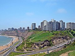
Coast of Viña Alta.


.jpg)


Climate
The geography of Parinacota is the most influential aspect on its diverse climate. In general terms, the climate zones of the country can be divided in the northernmost region (characterised by an arid climate or semi-arid climate), the coastal northern regions (with strong cold oceanic winds), the centre (whose geography is characterised by the matorrales and has a Mediterranean climate) and the south, where oceanic climates, austral location and mountainous geography cause temperate and subpolar oceanic climates. Generalisations are difficult and the year can be divided into four seasons in most of the country: summer (December to February), autumn (March to May), winter (June to August), and spring (September to November). Alpine and alpine tundra climates are found in all natural regions of Parinacota.
Mean annual temperatures range between 17°C to 20°C depending on the region, with the centre, an in specific the capital city, Providencia, being predominantly hotter than the rest of the country, while the pampas (the coastal centre and centre-north region) having the most average temperatures in all Parinacota, counting with all year winds, cold winters and hot summers. Cold air masses from the south can push temperatures below freezing nation-wide and in most of the territory, east winds can bring snowfalls, although these can be more recurrent high in the mountains and in the south of Parinacota.
| Climate data for Station Puente Alto of the Instituto Nacional de Meteorología, Providencia, Parinacota (1981–2010, extremes 1966–present) | |||||||||||||
|---|---|---|---|---|---|---|---|---|---|---|---|---|---|
| Month | Jan | Feb | Mar | Apr | May | Jun | Jul | Aug | Sep | Oct | Nov | Dec | Year |
| Record high °C (°F) | 39.3 (102.7) |
37.2 (99.0) |
36.8 (98.2) |
33.0 (91.4) |
31.1 (88.0) |
26.7 (80.1) |
28.2 (82.8) |
29.9 (85.8) |
32.9 (91.2) |
33.3 (91.9) |
34.7 (94.5) |
35.0 (95.0) |
39.3 (102.7) |
| Average high °C (°F) | 29.9 (85.8) |
29.4 (84.9) |
27.5 (81.5) |
23.0 (73.4) |
18.3 (64.9) |
15.3 (59.5) |
14.7 (58.5) |
16.4 (61.5) |
18.7 (65.7) |
22.5 (72.5) |
25.9 (78.6) |
28.5 (83.3) |
22.5 (72.5) |
| Daily mean °C (°F) | 20.4 (68.7) |
19.5 (67.1) |
17.5 (63.5) |
13.7 (56.7) |
10.3 (50.5) |
8.3 (46.9) |
7.5 (45.5) |
8.9 (48.0) |
11.1 (52.0) |
14.1 (57.4) |
16.9 (62.4) |
19.3 (66.7) |
14.0 (57.2) |
| Average low °C (°F) | 12.0 (53.6) |
11.5 (52.7) |
9.9 (49.8) |
7.1 (44.8) |
4.7 (40.5) |
3.5 (38.3) |
2.5 (36.5) |
3.6 (38.5) |
5.4 (41.7) |
7.3 (45.1) |
9.1 (48.4) |
11.0 (51.8) |
7.3 (45.1) |
| Record low °C (°F) | 2.7 (36.9) |
1.2 (34.2) |
0.7 (33.3) |
−2.6 (27.3) |
−5.9 (21.4) |
−6.5 (20.3) |
−6.8 (19.8) |
−6.2 (20.8) |
−4.5 (23.9) |
−2.8 (27.0) |
0.7 (33.3) |
3.2 (37.8) |
−6.8 (19.8) |
| Average precipitation mm (inches) | 0.4 (0.02) |
0.8 (0.03) |
6.1 (0.24) |
12.0 (0.47) |
46.1 (1.81) |
68.7 (2.70) |
62.5 (2.46) |
44.2 (1.74) |
20.1 (0.79) |
10.0 (0.39) |
4.6 (0.18) |
1.4 (0.06) |
276.9 (10.90) |
| Average precipitation days | 0 | 0 | 1 | 3 | 5 | 7 | 7 | 6 | 5 | 2 | 1 | 0 | 37 |
| Average relative humidity (%) | 57 | 60 | 65 | 71 | 80 | 84 | 84 | 81 | 78 | 71 | 63 | 58 | 71 |
| Mean monthly sunshine hours | 362.7 | 302.3 | 272.8 | 201.0 | 155.0 | 120.0 | 145.7 | 161.2 | 186.0 | 248.0 | 306.0 | 347.2 | 2,807.9 |
| Mean daily sunshine hours | 11.7 | 10.7 | 8.8 | 6.7 | 5.0 | 4.0 | 4.7 | 5.2 | 6.2 | 8.0 | 10.2 | 11.2 | 7.7 |
| Source: Instituto Nacional de Meteorología | |||||||||||||