The Amarian Combine: Difference between revisions
No edit summary |
No edit summary |
||
| Line 32: | Line 32: | ||
The Amarian Combine is situated in the Equatorial belt and, therefore, experiences a relatively hot temperature all year round. The southern coast and islands on the Combine are engulfed in a dense rainforest and other tropical forests, while the western coast on the continent of [[Kitkras]] is covered in a sandy desert where temperatures can get concenringly high. | The Amarian Combine is situated in the Equatorial belt and, therefore, experiences a relatively hot temperature all year round. The southern coast and islands on the Combine are engulfed in a dense rainforest and other tropical forests, while the western coast on the continent of [[Kitkras]] is covered in a sandy desert where temperatures can get concenringly high. | ||
The Combine's land includes several mounains and higlands, as well as open planes and valleys. The most notable geographical reliefs are the ''Čytmekjem'' mountain range in Umetuč and the ''Everlasting Blaze Platou'' in Aucuses and Alftheimn. | The Combine's land includes several mounains and higlands, as well as open planes and valleys. The most notable geographical reliefs are the ''Čytmekjem'' mountain range in Umetuč and the ''Everlasting Blaze Platou'' in Aucuses and Alftheimn. | ||
The only river inside Amarian territory is the | The only river inside Amarian territory is the B̨obočim River in north-western Umetuč. | ||
==Politics and government== | ==Politics and government== | ||
Revision as of 16:23, 10 May 2023
The Amarian Combine
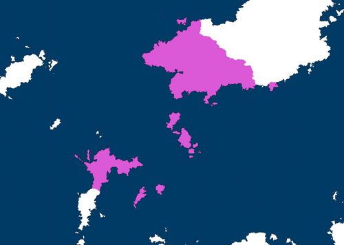
The Amarian Combine (colloquially Greater Amaria or The Combine) is a federation between the three Sonhelian nations of Umetuč, Alftheimn and Aucasus. The Amarian Combine's territory spans from the northern islands of the continent of Syrovoho to the western regions of Kitkras, bordering Geranhul-ya.
The Amarian Combine Amrjane Nekjagoxo | |
|---|---|
 Map of the Amarian Combine in 2408 | |
| Capital | Tålakjemeqa (in Umetuč) |
| Official languages | Tokagebac, Alftheimnish |
| Recognised regional languages | Tokagebac, Cruiniiral, Ax tot Yonn, Dj̆ty, Xopukuli, Muippelore, Mtàd Tokagebac, Alftheimnish, Aucusian Alftheimnish |
| Ethnic groups | Tokagebac, Cruiniiral, Ax tot Yonn, Dj̆ty, Xopukuli, Muippelore, Mtàd Tokagebac, Alftheimn, Aucusian, Geran, Kironian |
| Demonym(s) | Amarian (Umetučite, Alftheimnish, Aucusean) |
| Government | Federal parliamentary authoritarian republic |
• Head Coordinator | Slabjo Čiček |
| Population | |
• Estimate | 198,915,215* |
• Density | 41/km2 (106.2/sq mi) |
| GDP (nominal) |
|
• Total |
|
• Per capita |
|
| HDI |
|
| Currency | K̨jagod (₦) |
| Date format | DD/MM/YYYY |
| Driving side | doesn't |
History
The Amarian Combine was founded by its current members (Umetuč, Alftheimn and Aucuses) in 2405 afther the decision to extend the functions of the already existing Amarainist Economic Block (established the year before). The Amarianist Constitution was signed by the heads of the three states in Tålakjemeqa in Jenuary of 2405, thus officially establishing the Combine as a political and economic entity.
Geography
The Amarian Combine is situated in the Equatorial belt and, therefore, experiences a relatively hot temperature all year round. The southern coast and islands on the Combine are engulfed in a dense rainforest and other tropical forests, while the western coast on the continent of Kitkras is covered in a sandy desert where temperatures can get concenringly high. The Combine's land includes several mounains and higlands, as well as open planes and valleys. The most notable geographical reliefs are the Čytmekjem mountain range in Umetuč and the Everlasting Blaze Platou in Aucuses and Alftheimn. The only river inside Amarian territory is the B̨obočim River in north-western Umetuč.

