San Pera: Difference between revisions
Jump to navigation
Jump to search
(Created page with "{{Infobox settlement | name = San Pera | official_name = Cidade de São Pera | settlement_type = Cities in Benth...") |
No edit summary |
||
| Line 1: | Line 1: | ||
{{Infobox settlement | {{Infobox settlement | ||
| name | | name = San Pera | ||
| | | native_name = | ||
| settlement_type | | native_name_lang = | ||
| | | settlement_type = Capital City | ||
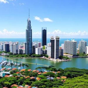
| | | image_skyline = [[File:Img-Qg2GBW1D9pJaBpZCBLZPR.jpg|thumb]] | ||
| | | image_alt = | ||
| | | image_caption = | ||
| | | image_flag = | ||
| | | flag_alt = | ||
| | | image_seal = | ||
| | | seal_alt = | ||
| | | image_shield = | ||
| | | shield_alt = | ||
} | | etymology = | ||
| nickname = Capybara City | |||
| motto = | |||
| image_map = | |||
| map_alt = | |||
| map_caption = | |||
| pushpin_map = | |||
| pushpin_map_alt = | |||
| pushpin_map_caption = | |||
| pushpin_label_position = | |||
| coordinates = <!-- {{Coord}} --> | |||
| coor_pinpoint = | |||
| coordinates_footnotes = | |||
| subdivision_type = Country | |||
| subdivision_name = [[Bentho]] | |||
| subdivision_type1 = Administrative District (Province) | |||
| subdivision_name1 = [[State of San Pera]] | |||
| subdivision_type2 = | |||
| subdivision_name2 = | |||
| subdivision_type3 = | |||
| subdivision_name3 = | |||
| established_title = Founded | |||
| established_date = May 1st, 1589 | |||
| founder = [[Artur Vila Leitão]] | |||
| seat_type = | |||
| seat = | |||
| government_footnotes = | |||
| leader_party = [[International Left Leauge (Bentho)|ILL]] | |||
| leader_title = [[Mayor of San Pera|Mayor]] | |||
| leader_name = [[Estela Prestes Belluci]] | |||
| leader_party2 = [[International Left Leauge (Bentho)|ILL]] | |||
| leader_title2 = Vice-Mayor | |||
| leader_name2 = [[Emanuel Leal dos Reis]] | |||
| unit_pref = <!-- or UK --> | |||
<!-- ALL fields with measurements have automatic unit conversion --> | |||
<!-- for references: use <ref> tags --> | |||
| area_footnotes = | |||
| area_urban_footnotes = <!-- <ref> </ref> --> | |||
| area_rural_footnotes = <!-- <ref> </ref> --> | |||
| area_metro_footnotes = <!-- <ref> </ref> --> | |||
| area_magnitude = <!-- use only to set a special wikilink --> | |||
| area_note = | |||
| area_water_percent = | |||
| area_rank = | |||
| area_blank1_title = | |||
| area_blank2_title = | |||
<!-- square miles --> | |||
| area_total_sq_mi = | |||
| area_land_sq_mi = | |||
| area_water_sq_mi = | |||
| area_urban_sq_mi = 96.5 | |||
| area_rural_sq_mi = | |||
| area_metro_sq_mi = 714 | |||
| area_blank1_sq_mi = | |||
| area_blank2_sq_mi = | |||
<!-- acres --> | |||
| area_total_acre = | |||
| area_land_acre = | |||
| area_water_acre = | |||
| area_urban_acre = | |||
| area_rural_acre = | |||
| area_metro_acre = | |||
| area_blank1_acre = | |||
| area_blank2_acre = | |||
| length_mi = | |||
| width_mi = | |||
| dimensions_footnotes = | |||
| elevation_footnotes = | |||
| elevation_ft = | |||
| population_as_of = 2023 | |||
| population_footnotes = | |||
| population_total = 1,947,103 ([[Cities in Bentho|2nd]]) | |||
| population_density_sq_mi= auto | |||
| population_note = [[San Pera Metropolitan Area]] (2,493,098) | |||
| population_demonym = | |||
| timezone1 = | |||
| utc_offset1 = | |||
| timezone1_DST = | |||
| utc_offset1_DST = | |||
| postal_code_type = | |||
| postal_code = | |||
| area_code_type = | |||
| area_code = | |||
| iso_code = | |||
| website = cityofsanpera.gov.bo | |||
| footnotes = | |||
}} | |||
Revision as of 07:12, 22 May 2023
San Pera | |
|---|---|
Capital City | |
| Nickname: Capybara City | |
| Country | Bentho |
| Administrative District (Province) | State of San Pera |
| Founded | May 1st, 1589 |
| Founded by | Artur Vila Leitão |
| Government | |
| • Mayor | Estela Prestes Belluci (ILL) |
| • Vice-Mayor | Emanuel Leal dos Reis |
| Area | |
| • Urban | 250 km2 (96.5 sq mi) |
| • Metro | 1,850 km2 (714 sq mi) |
| Population (2023) | |
| • Capital City | 1,947,103 (2nd) |
| San Pera Metropolitan Area (2,493,098) | |
| Website | cityofsanpera.gov.bo |
