Godoy Cruz: Difference between revisions
Jump to navigation
Jump to search
mNo edit summary |
mNo edit summary |
||
| Line 21: | Line 21: | ||
|other_symbol_type = <!--Use if a further symbol exists, e.g. hymn--> | |other_symbol_type = <!--Use if a further symbol exists, e.g. hymn--> | ||
|other_symbol = | |other_symbol = | ||
|image_map = <!--e.g. LocationCountry.svg--> File: | |image_map = <!--e.g. LocationCountry.svg--> File:MendoMap.png | ||
|loctext = <!--text description of location of country--> | |loctext = <!--text description of location of country--> | ||
|alt_map = <!--alt text for map--> | |alt_map = <!--alt text for map--> | ||
Latest revision as of 19:10, 10 August 2023
Godoy Cruz People's Republic | |
|---|---|
| Motto: Sonrisa, Sol y buen vino (Spanish) Smile, sun, good wine | |
 | |
| Capital | Vallecito (executive) Godoy Cruz (legislative) Potrerillos (judiciary) |
| Largest city | Vallecito |
| Official languages | Spanish |
| Demonym(s) | Tombino Mendocino |
| Government | Unitary semi-presidential republic with executive presidency |
• President | Américo Figueroa |
• Prime Minister | Anabel Fernandez Sagasti |
| Legislature | National Legislature |
| Area | |
• Total | 148,827 km2 (57,462 sq mi) |
| Population | |
• 2022 estimate | 2 014 533 |
| Currency | Tomba (GCT) |
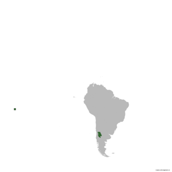
Godoy Cruz officially the Godoy Cruz People's Republic is a country located in the Southern Cone of South America, renowned by its lush flora and fauna, impressive wineyards and benevolent climate. It comprises of 18 departments and its Executive capital city is Vallecito. Godoy Cruz has been witness of a gradual and progressive economic and social development, turning the country one of the safest and environmentally pure to live in.
Geography
Climate
In Godoy Cruz, it predominates the aridity. Most of the territory falls under the Hot semi-arid climate (BSh). However, it changes drastically going to the Andes zone as Cold semi-arid or even tundra.
Most of the precipitations fall from April to July, both as rainfall and snow in the mountain range.
| Climate data for Vallecito | |||||||||||||
|---|---|---|---|---|---|---|---|---|---|---|---|---|---|
| Month | Jan | Feb | Mar | Apr | May | Jun | Jul | Aug | Sep | Oct | Nov | Dec | Year |
| Average high °C (°F) | 39.2 (102.6) |
44.9 (112.8) |
36.6 (97.9) |
31.1 (88.0) |
28.6 (83.5) |
21.5 (70.7) |
16.6 (61.9) |
19.7 (67.5) |
24.8 (76.6) |
29.3 (84.7) |
33.3 (91.9) |
37.4 (99.3) |
30.2 (86.5) |
| Daily mean °C (°F) | 27.4 (81.3) |
30.8 (87.4) |
24.9 (76.8) |
19.7 (67.5) |
16.4 (61.5) |
10.9 (51.6) |
8.0 (46.4) |
10.7 (51.3) |
15.0 (59.0) |
19.3 (66.7) |
22.8 (73.0) |
26.3 (79.3) |
19.4 (66.8) |
| Average low °C (°F) | 15.6 (60.1) |
16.8 (62.2) |
13.2 (55.8) |
8.3 (46.9) |
4.3 (39.7) |
0.4 (32.7) |
−0.5 (31.1) |
1.8 (35.2) |
5.3 (41.5) |
9.4 (48.9) |
12.4 (54.3) |
15.3 (59.5) |
8.5 (47.3) |
| Average precipitation mm (inches) | 0 (0) |
0 (0) |
0 (0) |
64 (2.5) |
81 (3.2) |
90 (3.5) |
95 (3.7) |
0 (0) |
0 (0) |
0 (0) |
0 (0) |
0 (0) |
330 (12.9) |
| Source: [NAME OF THE WEBSITE] | |||||||||||||
