User:Greatianempire/Sandbox 1: Difference between revisions
No edit summary |
No edit summary |
||
| Line 1: | Line 1: | ||
== Skiperia == | {{Region icon Skiperia}} | ||
{{Infobox country | |||
|native_name = Конфедерата ШЌиптарие (Konfederata Skqitarie) - Skiperian <br> Шкиртарска конфедерације (Skiptarska Konfederachije) - Malizian | |||
|conventional_long_name = Skiperian Confederation | |||
|common_name = Skiperia | |||
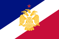
|image_flag = [[File:National Flag of Skiperia.png|200px]] | |||
|image_coat = File:Ilbo nSeal Reworked.png | |||
|symbol_type = Seal | |||
|national_motto = 一つの旗の下にすべての民族を!<br><small>''All peoples under one banner!''</small> | |||
|national_anthem = <br> <small> 調和歌 (Chōwa Uta) <br>''Melody of Harmony''</small><br> | |||
[[File:MediaPlayer.png|link=https://www.youtube.com/watch?v=UbD3r1MRB6s|200px]] | |||
|royal_anthem = | |||
|other_symbol_type = State Seal | |||
|other_symbol = <div style="padding:0.2em;">イルボン國璽 (''Dai Ilbon kokuji'')<br>''National Seal of Greater Ilbon''<br/>[[File:Gyomei kokuji.svg|80px|Seal of the State of Ilbon]]</div> | |||
|image_map = File:Ilbon Revised Map with prefectures.png | |||
|alt_map = | |||
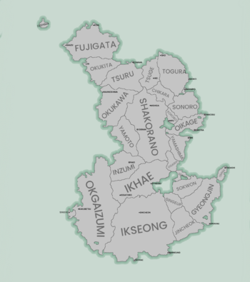
|map_caption = Prefectural Map of Ilbon | |||
|image_map2 = | |||
|alt_map2 = | |||
|map_caption2 = | |||
|capital = [[Oikage]] | |||
|largest_city = [[Oikage]] | |||
|official_languages = {{wp|Japanese language|Ilbon-eo}} | |||
|national_languages = {{wp|Korean language|Kokuri-eo}}<br>{{wp|Manchu language|Kita-eo}}<br>{{wp|Okinawan language|Inma-eo}}<br>{{wp|Ryukyuan languages|Pone-eo}} | |||
|regional_languages = | |||
|languages_type = | |||
|languages = | |||
|ethnic_groups = | |||
|ethnic_groups_year = | |||
|demonym = Ilbonese (ethnic)<br>Ilbonese (citizen) | |||
|legislature = [[Ilbonese Diet|Kokkai]] | |||
|lower_house = | |||
|upper_house = | |||
|government_type = {{wp|Unitary state|Unitary}} {{wp|Semi-presidential republic|Semi-Presidential}} {{wp|Republic}} | |||
|leader_title1 = {{wp|President}} | |||
|leader_name1 = [[Kuse Shig]] | |||
|leader_title2 = {{wp|Vice President}} | |||
|leader_name2 = [[Oszawa Mitsuo]] | |||
|sovereignty_type = | |||
|sovereignty_note = | |||
|established_event1 = The First Kingdom | |||
|established_date1 = 551 CE | |||
|established_event2 = Domain | |||
|established_date2 = 1485 CE | |||
|established_event3 = Federal Republic | |||
|established_date3 = 1815 CE | |||
|established_event4 = Socialist Peoples Republic | |||
|established_date4 = 1910 CE | |||
|established_event5 = Kingdom | |||
|established_date5 = 1939 CE | |||
|established_event6 = Republic | |||
|established_date6 = 1996 CE | |||
|area_rank = | |||
|area_magnitude = | |||
|area_km2 = | |||
|area_sq_mi = | |||
|area_footnote = | |||
|percent_water = | |||
|area_label = | |||
|area_dabodyalign = | |||
|population_estimate = {{IncreaseNeutral}} 146,000,000 | |||
|population_estimate_rank = | |||
|population_estimate_year = 2020 | |||
|population_census = {{IncreaseNeutral}} 146,998,121 | |||
|population_census_year = 2022 | |||
|population_density_km2 = | |||
|population_density_sq_mi = | |||
|population_density_rank = | |||
|GDP_PPP = | |||
|GDP_PPP_rank = | |||
|GDP_PPP_year = 2022 estimate | |||
|GDP_PPP_per_capita = 52,128 $ | |||
|GDP_PPP_per_capita_rank = | |||
|GDP_nominal = 10.5 Trillion $ | |||
|GDP_nominal_rank = | |||
|GDP_nominal_year = 2022 estimate | |||
|GDP_nominal_per_capita = | |||
|GDP_nominal_per_capita_rank = | |||
|Gini = 0.391 | |||
|Gini_rank = | |||
|Gini_change = | |||
|Gini_year = 2022 estimate | |||
|Gini_category = | |||
|HDI = 0.925 | |||
|HDI_rank = | |||
|HDI_year = 2022 estimate | |||
|HDI_change = | |||
|HDI_category = | |||
|currency = [[Imperial Yen|Yen]] | |||
|currency_code = YYN | |||
|time_zone = | |||
|utc_offset = | |||
|time_zone_DST = | |||
|antipodes = | |||
|date_format = dd.mm.yyyy | |||
|DST_note = | |||
|utc_offset_DST = | |||
|drives_on = left | |||
|cctld = .dr | |||
|iso3166code = DR | |||
|calling_code = | |||
|image_map3 = | |||
|alt_map3 = | |||
|footnotes = | |||
|footnote1 = | |||
|footnote2 = | |||
}} | |||
'''Ilbon''' (Ilbonese:イルボン, Ielbon or Irubon, officially known as the '''Republic of Ilbon''', and formally Irubonkoku) is an island nation located south of [[Agleia]]. It is situated to the south of Agleia and to the north of [[Sorenwey]]. Ilbon has no natural land borders, and therefore does not have any neighboring states on its borders. Because of its status as an island nation, Ilbon is surrounded on all sides by smaller island chains, with there being nearly 4,000 smaller islands surrounding the nation on all sides. Ilbon possesses many smaller city-states across the coasts of Sorenwey and Agleia, it also claims parts of modern [[Todavil-Nadu]]. Oikage is the nations largest city and capitol, followed by [[Osaga]], [[Kokasa]], [[Mie]], [[Niinoshima]], and [[Ar]]. | |||
Ilbon is the 8th most populous country in the world, and is one of the most densly populated. Oikage itself is home to nearly 20 million people and is so large that it has become its own prefecture, and is the largest urban metropolitan region in the world. The eastern coast of the nation is the most densly populated with the population density decreasing the further west-ward one travels. Most of the primarily tropical nation's terrain is hilly or flat, with the nations only mountain range being located along the western coast of the island. Ilbon is divided into 11 regions, which are then further divided up into 22 prefectures and 3 [[Special economic zones]]. | |||
==Etymology== | |||
Revision as of 02:57, 7 November 2023
Skiperian Confederation Конфедерата ШЌиптарие (Konfederata Skqitarie) - Skiperian Шкиртарска конфедерације (Skiptarska Konfederachije) - Malizian | |
|---|---|
| Motto: 一つの旗の下にすべての民族を! All peoples under one banner! | |
| Anthem: 調和歌 (Chōwa Uta) Melody of Harmony | |
| State Seal | |
 Prefectural Map of Ilbon | |
| Capital and largest city | Oikage |
| Official languages | Ilbon-eo |
| Recognised national languages | Kokuri-eo Kita-eo Inma-eo Pone-eo |
| Demonym(s) | Ilbonese (ethnic) Ilbonese (citizen) |
| Government | Unitary Semi-Presidential Republic |
| Kuse Shig | |
| Oszawa Mitsuo | |
| Legislature | Kokkai |
| Establishment | |
• The First Kingdom | 551 CE |
• Domain | 1485 CE |
• Federal Republic | 1815 CE |
• Socialist Peoples Republic | 1910 CE |
• Kingdom | 1939 CE |
• Republic | 1996 CE |
| Population | |
• 2020 estimate | |
• 2022 census | |
| GDP (PPP) | 2022 estimate estimate |
• Per capita | 52,128 $ |
| GDP (nominal) | 2022 estimate estimate |
• Total | 10.5 Trillion $ |
| Gini (2022 estimate) | 0.391 low |
| HDI (2022 estimate) | 0.925 very high |
| Currency | Yen (YYN) |
| Date format | dd.mm.yyyy |
| Driving side | left |
| ISO 3166 code | DR |
| Internet TLD | .dr |
Ilbon (Ilbonese:イルボン, Ielbon or Irubon, officially known as the Republic of Ilbon, and formally Irubonkoku) is an island nation located south of Agleia. It is situated to the south of Agleia and to the north of Sorenwey. Ilbon has no natural land borders, and therefore does not have any neighboring states on its borders. Because of its status as an island nation, Ilbon is surrounded on all sides by smaller island chains, with there being nearly 4,000 smaller islands surrounding the nation on all sides. Ilbon possesses many smaller city-states across the coasts of Sorenwey and Agleia, it also claims parts of modern Todavil-Nadu. Oikage is the nations largest city and capitol, followed by Osaga, Kokasa, Mie, Niinoshima, and Ar.
Ilbon is the 8th most populous country in the world, and is one of the most densly populated. Oikage itself is home to nearly 20 million people and is so large that it has become its own prefecture, and is the largest urban metropolitan region in the world. The eastern coast of the nation is the most densly populated with the population density decreasing the further west-ward one travels. Most of the primarily tropical nation's terrain is hilly or flat, with the nations only mountain range being located along the western coast of the island. Ilbon is divided into 11 regions, which are then further divided up into 22 prefectures and 3 Special economic zones.

