San Salvacion: Difference between revisions
Jump to navigation
Jump to search
No edit summary |
|||
| Line 112: | Line 112: | ||
TBD | TBD | ||
===Foreign relations=== | ===Foreign relations=== | ||
{{Main|Foreign relations of San Salvacion}} | |||
TBD | TBD | ||
Revision as of 02:59, 7 December 2023
This article is incomplete because it is pending further input from participants, or it is a work-in-progress by one author. Please comment on this article's talk page to share your input, comments and questions. Note: To contribute to this article, you may need to seek help from the author(s) of this page. |
Salvanese Republic Republica Salvanesa | |
|---|---|
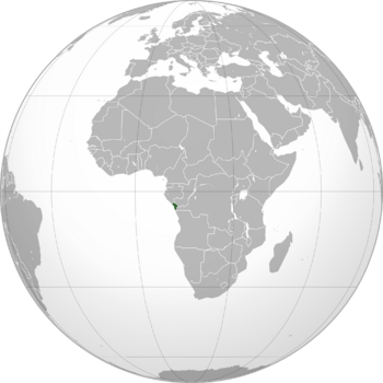
 Location of San Salvacion in Africa | |
| Capital | Punta Negra |
| Largest city | Villa Amelía |
| Official languages | Spanish |
| Ethnic groups (2023) |
|
| Religion (2023) |
|
| Demonym(s) | Salvanese |
| Government | Unitary semi-presidential republic |
| Legislature | National Assembly |
| Independence | |
• From Spain | 1956 |
| Area | |
• Total | 22,084 km2 (8,527 sq mi) |
| Population | |
• 2023 census | 8,341,567 |
| GDP (PPP) | 2023 estimate |
• Total | $650.075 billion |
• Per capita | $77,932 |
| GDP (nominal) | 2023 estimate |
• Total | $456.701 billion |
• Per capita | $54,750 |
| Gini (2023) | low |
| HDI (2023) | very high |
| Time zone | UTC+1 (WAT) |
| Date format | dd-mm-yyyy |
San Salvacion, officially known as the Salvanese Republic (Spanish: República Salvanesa), is a country located on the Atlantic coast of Central Africa. It is bordered by Congo-Brazzaville to the northeast, Gabon to the northwest, DR Congo to the east, and the Bay of Cabinda to the west.
Etymology
TBD
History
TBD
Geography
Climate
TBD
Environment
TBD
Politics and government
Government
TBD
Administrative divisions
TBD
Military
TBD
Foreign relations
TBD
Economy
TBD
Infrastructure
TBD
Demographics
TBD
Culture
TBD
See also
TBD

