T'kampa Community: Difference between revisions
No edit summary |
No edit summary |
||
| Line 37: | Line 37: | ||
| established_event2 = | | established_event2 = | ||
| established_date2 = | | established_date2 = | ||
| time_zone = [[T'kampa Standard Time]] and [[ | | time_zone = [[T'kampa Standard Time]] and [[Awaso Time]] | ||
| utc_offset = | | utc_offset = | ||
| drives_on = right | | drives_on = right | ||
| calling_code = {{ubl|+65 ([[Telephone numbers in West T'kampa|West T'kampa]])|+102 ([[Telephone numbers in | | calling_code = {{ubl|+65 ([[Telephone numbers in West T'kampa|West T'kampa]])|+102 ([[Telephone numbers in East T'kampa|East T'kampa]])}} | ||
| cctld = {{unbulleted list|[[.tk]] ([[West T'kampa]])|[[.dt]] ([[East T'kampa]])}} | | cctld = {{unbulleted list|[[.tk]] ([[West T'kampa]])|[[.dt]] ([[East T'kampa]])}} | ||
| area_rank = | | area_rank = | ||
| Line 72: | Line 72: | ||
| Emblem || style="text-align:center"|[[File:WtkEmblem.png|90px]] || style="text-align:center"|[[File:EtkEmblem.png|90px]] | | Emblem || style="text-align:center"|[[File:WtkEmblem.png|90px]] || style="text-align:center"|[[File:EtkEmblem.png|90px]] | ||
|- | |- | ||
| Capital || [[Kura]] || [[ | | Capital || [[Kura]] || [[Awaso]] | ||
|- | |- | ||
| Official languages || colspan="2" align="center" | T'kampan | | Official languages || colspan="2" align="center" | T'kampan | ||
Revision as of 02:15, 22 March 2024
T'kampa | |
|---|---|
Anthem:
| |
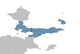
 T'kampa shown in blue | |
| Capital | |
| Largest city | Markium |
| Official languages | T'kampan |
| Demonym(s) | T'kampan |
| Government | In dispute between West T'kampa and East T'kampa |
| Raro Rutkemenmi | |
| Rakase Ratsimanjava | |
| Shasa Moso | |
| Danoi Asalat | |
| Legislature | |
| Area | |
• Total | 223,172 km2 (86,167 sq mi) |
| Population | |
• 2017 estimate | 27,053,198 |
• Density | 349.06/km2 (904.1/sq mi) |
| Time zone | T'kampa Standard Time and Awaso Time |
| Driving side | right |
| Calling code |
|
| Internet TLD | |
T'kampa is a region in the Yulur Peninsula in Northeast Muambia. The division started in 1953 with the declaration of the Republic of T'kampa, the legitimacy of which is disputed. Since 1968, T'kampa has been divided along the T'kampan Demilitarized Zone, otherwise known as Darimo's line.
The T'kampa Community was established in 1994 as both West and East T'kampa joined the World Congress. The official aim of the organization is to facilitate cooperation where possible between both the west and east at the expense of neither side. It also includes the T'kampan diaspora, and allows for families separated by the split to visit one another.
Comparison of West and East T'kampa
| Indicator | West T'kampa | East T'kampa |
|---|---|---|
| Formal name in English | Republic of T'kampa (ROT) | Democratic T'kampa (DT) |
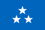
| Flag |  |

|
| Emblem |  |

|
| Capital | Kura | Awaso |
| Official languages | T'kampan | |
| Government | Presidential system Representative democracy |
One-party state Meritocracy |
| Leader | President of T'kampa | Secretary-General of the Democratic People's Rally |
| Formal consolidation | 7 May 1968 | 20 May 1968 |
| Population (2023 est.) | 11,198,836 | 15,854,362 |
| GDP total (2019 / 2023 est.) | TBD | TBD |
| GDP/capita (2019 / 2023 est.) | TBD | TBD |
| Currency | T'kampan neto | T'kampan sidol |
| Calling code | +65 | +102 |
| Internet TLD | .tk | .dt |
| Drives on the | right | |
| Active military personnel | 300,000 | |
| Military expenditure (2010/2022) | TBD | TBD |
Three truths
Since its founding, the T'kampa Community has adhered to the three truths, which are agreed upon by all parties:
- There is one T'kampa, existing outside of politics, that is indivisible
- Cooperation between the two states in T'kampa is necessary for any reasonable political ends
- The diaspora is a legitimate extension of T'kampa


