Culiacan: Difference between revisions
Jump to navigation
Jump to search
No edit summary |
No edit summary |
||
| Line 35: | Line 35: | ||
|established_event3 = The Culiacanan Empire | |established_event3 = The Culiacanan Empire | ||
|established_date3 = 275 BCE - 1571 CE | |established_date3 = 275 BCE - 1571 CE | ||
|established_event4 = The Espicutan Colony | |established_event4 = The Espicutan Colony | ||
|established_date4 = 1571 - 1805 CE | |established_date4 = 1571 - 1805 CE | ||
|established_event5 = The Catholic Kingdom | |established_event5 = The Catholic Kingdom | ||
Revision as of 00:00, 4 June 2024
Democratic People's Republic of Culiacan República Democrática Popular de Culiacán | |
|---|---|
| Motto: ¡Larga Vida a la Revolución! (Long Live the Revolution) | |
| Anthem: ¡La Revolución Está Cumplida! | |
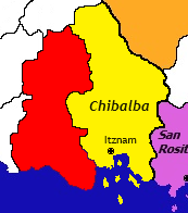
 Map of Culiacan next to Chibalba | |
| Capital and largest city | Carabanchel |
| Official languages | Culiacanan |
| Recognised national languages | Chibalban, Italian, Latin |
| Ethnic groups |
|
| Demonym(s) | Culiacanan |
| Government | Alcazarist Single Party State |
• Secretary-General | Lia Rebeca Vega |
• President | Marcos Barceló Vaqueto |
| Legislature | Supreme Soviet |
| Commissariat of the People | |
| History | |
• Culiacanan Prehistory | Circa 25000 BCE |
• The Aborigen Kingdoms | Circa 3000 BCE - 275 BCE |
• The Culiacanan Empire | 275 BCE - 1571 CE |
• The Espicutan Colony | 1571 - 1805 CE |
• The Catholic Kingdom | 1805 - 1912 CE |
• The Alcazarist Revolution | 1912 CE - Present |
| Area | |
• Total | 351,750 km2 (135,810 sq mi) |
• Water (%) | 9.12% |
| Population | |
• 2024 census | 52,701,592 |
• Density | 149.82/km2 (388.0/sq mi) |
| GDP (nominal) | 2024 estimate |
• Total | $2.11 Trillion |
• Per capita | $40,036.74 |
| Gini | 25.325 low |
| HDI | 0.912 very high |
| Currency | Culiacanan Peso (P$) (CUL) |
| Date format | dd-mm-yy |
| Driving side | right |
| Internet TLD | .cul |
Culiacan, officially the Democratic People's Republic of Culiacan (Culiacanan: República Democrática Popular de Culiacán) is a sovereign country in southwest Marudin in Teremara. It is bordered to the east by Chibalba and to the south by Madurin Sea.

