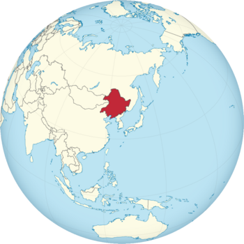
Aisin Gajur: Difference between revisions
Jump to navigation
Jump to search
mNo edit summary |
mNo edit summary |
||
| Line 14: | Line 14: | ||
|alt_coat = <!--alt text for coat of arms--> | |alt_coat = <!--alt text for coat of arms--> | ||
|symbol_type = <!--emblem, seal, etc (if not a coat of arms)--> | |symbol_type = <!--emblem, seal, etc (if not a coat of arms)--> | ||
|national_motto = <!--in inverted commas and wikilinked if link exists--> | |national_motto = <!--in inverted commas and wikilinked if link exists--> {{MongolUnicode|ᠪᡝᡳᠰᡝ ᠨᡳᠶᠠᠯᠮᠠ ᠠᠮᠪᠠ ᡤᡠᡵᡠᠨ ᡳ ᡝᠮᡠ ᡨᠠᠩᡤᠠᠯᠠ ᠪᡝ ᡤᡳᠰᡠᡵᡝ ᠪᡝ ᡤᠠᡩᠠ|style=height:50px}}<br>''Beise niyalma amba gurun i emu tanggala be gisure be gādā'' | ||
|englishmotto = <!--English language version of motto--> | |englishmotto = <!--English language version of motto--> Workers of the world, unite! | ||
|national_anthem = <!--in inverted commas and wikilinked if link exists--> | |national_anthem = <!--in inverted commas and wikilinked if link exists--> | ||
|royal_anthem = <!--in inverted commas and wikilinked if link exists--> | |royal_anthem = <!--in inverted commas and wikilinked if link exists--> | ||
| Line 30: | Line 30: | ||
|image_map2_size = <!--Map size in number of pixels--> | |image_map2_size = <!--Map size in number of pixels--> | ||
|capital = <!--Name of country/territory's capital, wikilinked if link exists--> Ilmin Gasha | |capital = <!--Name of country/territory's capital, wikilinked if link exists--> Ilmin Gasha | ||
|coordinates = <!-- Coordinates for capital, using {{tl|coord}} --> | |coordinates = <!-- Coordinates for capital, using {{tl|coord}} --> 41° 48' 09'' N 123° 25' 41'' E | ||
|largest_city = <!--Name of country/territory's largest city. Use "capital" (without quotation marks) if it's the capital.--> | |largest_city = <!--Name of country/territory's largest city. Use "capital" (without quotation marks) if it's the capital.--> capital | ||
|largest_settlement_type = <!--Type of settlement if largest settlement not a city--> | |largest_settlement_type = <!--Type of settlement if largest settlement not a city--> largest city | ||
|largest_settlement = <!--Name of largest settlement--> | |largest_settlement = <!--Name of largest settlement--> | ||
|official_languages = <!--Languages recognised in legislation, constitution, etc--> | |official_languages = <!--Languages recognised in legislation, constitution, etc--> [[wikipedia:Manchu language|Manchu]] | ||
|national_languages = <!--Country/territory-wide languages recognised but not necessarily in country/territory-wide law, etc--> | |national_languages = <!--Country/territory-wide languages recognised but not necessarily in country/territory-wide law, etc--> | ||
|regional_languages = <!--Languages recognised or associated with particular regions within the country/territory--> | |regional_languages = <!--Languages recognised or associated with particular regions within the country/territory--> | ||
| Line 70: | Line 70: | ||
|area_rank = | |area_rank = | ||
|area = <!--Major area size (in [[Template:convert]] either km2 or sqmi first)--> | |area = <!--Major area size (in [[Template:convert]] either km2 or sqmi first)--> | ||
|area_km2 = <!--Major area size (in square km)--> | |area_km2 = <!--Major area size (in square km)--> 1,266,869 | ||
|area_sq_mi = <!--Area in square mi (requires area_km2)--> | |area_sq_mi = <!--Area in square mi (requires area_km2)--> | ||
|area_footnote = <!--Optional footnote for area--> | |area_footnote = <!--Optional footnote for area--> | ||
|percent_water = | |percent_water = | ||
|area_label = <!--Label under "Area" (default is "Total")--> | |area_label = <!--Label under "Area" (default is "Total")--> Total | ||
|area_label2 = <!--Label below area_label (optional)--> | |area_label2 = <!--Label below area_label (optional)--> | ||
|area_data2 = <!--Text after area_label2 (optional)--> | |area_data2 = <!--Text after area_label2 (optional)--> | ||
|population_estimate = | |population_estimate = 121,163,770 | ||
|population_estimate_rank = | |population_estimate_rank = | ||
|population_estimate_year = | |population_estimate_year = | ||
| Line 100: | Line 100: | ||
|Gini_rank = | |Gini_rank = | ||
|Gini_year = | |Gini_year = | ||
|HDI_year = <!-- Please use the year to which the data refers, not the publication year--> | |HDI_year = <!-- Please use the year to which the data refers, not the publication year--> | ||
|HDI = <!--(Human Development Index; input number only; valid values are between 0 and 1)--> | |HDI = <!--(Human Development Index; input number only; valid values are between 0 and 1)--> 0.762 | ||
|HDI_change = <!--increase/decrease/steady; rank change from previous year--> | |HDI_change = <!--increase/decrease/steady; rank change from previous year--> | ||
|HDI_rank = | |HDI_rank = | ||
|HDI_ref = <!--(for any ref/s to associate with HDI number)--> | |HDI_ref = <!--(for any ref/s to associate with HDI number)--> | ||
|currency = <!--Name/s of currency/ies used in country/territory--> | |currency = <!--Name/s of currency/ies used in country/territory--> Ardvalyut | ||
|currency_code = <!--ISO 4217 code/s for currency/ies (each usually three capital letters)--> | |currency_code = <!--ISO 4217 code/s for currency/ies (each usually three capital letters)--> AGA | ||
|time_zone = <!--e.g. GMT, PST, AST, etc, etc (wikilinked if possible)--> | |time_zone = <!--e.g. GMT, PST, AST, etc, etc (wikilinked if possible)--> | ||
|utc_offset = <!--in the form "+N", where N is number of hours offset--> | |utc_offset = <!--in the form "+N", where N is number of hours offset--> | ||
Revision as of 18:00, 4 June 2024
People's Republic of Aisin Gajur ᠨᡳᠶᠠᠯᠮᠠᡳᡵᡤᡝᠨ ᡤᡠᠨᡥᡝᡤᠣ ᠠᡳᠰᡳᠨ ᡤᠠᠵᡠᡵ Niyalmairgen Gunhego Aisin Gajur | |
|---|---|
| Motto: ᠪᡝᡳᠰᡝ ᠨᡳᠶᠠᠯᠮᠠ ᠠᠮᠪᠠ ᡤᡠᡵᡠᠨ ᡳ ᡝᠮᡠ ᡨᠠᠩᡤᠠᠯᠠ ᠪᡝ ᡤᡳᠰᡠᡵᡝ ᠪᡝ ᡤᠠᡩᠠ Beise niyalma amba gurun i emu tanggala be gisure be gādā Workers of the world, unite! | |
 | |
| Capital and largest city | Ilmin Gasha 41° 48' 09 N 123° 25' 41 E |
| Official languages | Manchu |
| Demonym(s) | Manchu |
| Government | Unitary one-party socialist republic |
• President | Sholontu Bohori |
• Prime Minister | Eje Ȗndusun |
| Legislature | Great Khural |
| Area | |
• Total | 1,266,869 km2 (489,141 sq mi) |
| Population | |
• Estimate | 121,163,770 |
| HDI | 0.762 high |
| Currency | Ardvalyut (AGA) |
