User:Skelecorn Inc/sandbox1: Difference between revisions
Jump to navigation
Jump to search
No edit summary |
No edit summary |
||
| Line 33: | Line 33: | ||
|map_caption2 = <!--Caption to place below second map--> | |map_caption2 = <!--Caption to place below second map--> | ||
|image_map2_size = <!--Map size in number of pixels--> | |image_map2_size = <!--Map size in number of pixels--> | ||
|capital = | |capital = [[Manasind]] <!--Name of country/territory's capital, wikilinked if link exists--> | ||
|coordinates = <!-- Coordinates for capital, using {{tl|coord}} --> | |coordinates = <!-- Coordinates for capital, using {{tl|coord}} --> | ||
|largest_city = | |largest_city = Manasind | ||
|official_languages = Zangoai <!--Languages recognised in legislation, constitution, etc--> | |official_languages = Zangoai <!--Languages recognised in legislation, constitution, etc--> | ||
|national_languages = <!--Country/territory-wide languages recognised but not necessarily in country/territory-wide law, etc--> | |national_languages = <!--Country/territory-wide languages recognised but not necessarily in country/territory-wide law, etc--> | ||
Revision as of 23:32, 25 July 2024
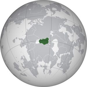
Republic of Zangoaistan د زانګویستان جمهوریت | |
|---|---|
|
Flag | |
 | |
| Capital and largest city | Manasind |
| Official languages | Zangoai |
| Ethnic groups |
|
| Religion |
|
| Demonym(s) | Zangoaistani |
| Government | Unitary presidential republic |
| Formation | |
• Zangoai coup d'état | 1975 |
• Zangoai Revolution | 1999 |
| Area | |
• Total | 717,332 km2 (276,963 sq mi) |
| Population | |
• Estimate | 9,131,048 |
• Density | 12.7/km2 (32.9/sq mi) |
| Currency | Kherazi (ZGK) |
| Time zone | UTC-2 to -3 (UTC) |
| Driving side | right |
| ISO 3166 code | ZG |
| Internet TLD | .zg |
NOTE TO SELF: complete flag, emblem, cities, GDP, historical dates
