Western Cona County: Difference between revisions
Jump to navigation
Jump to search
No edit summary |
No edit summary |
||
| Line 13: | Line 13: | ||
| position = center | | position = center | ||
| size = 270 | | size = 270 | ||
| color = white | |||
| foot_montage = Images, from top down, left to right: Coastal [[Ule'eka]], Downtown Ule'eka, [[Mount Urupaka]], [[Enchanted Peninsula, Garetolia|the Enchanted Peninsula]], | | foot_montage = Images, from top down, left to right: Coastal [[Ule'eka]], Downtown Ule'eka, [[Mount Urupaka]], [[Enchanted Peninsula, Garetolia|the Enchanted Peninsula]], | ||
}} | }} | ||
Revision as of 21:48, 5 April 2020
This article is incomplete because it is pending further input from participants, or it is a work-in-progress by one author. Please comment on this article's talk page to share your input, comments and questions. Note: To contribute to this article, you may need to seek help from the author(s) of this page. |
Western Cona County
Uru'kona Kone | |
|---|---|
    Images, from top down, left to right: Coastal Ule'eka, Downtown Ule'eka, Mount Urupaka, the Enchanted Peninsula, | |
 Seal | |
| Motto(s): Vilit'aka re' Kina'a (Greatness is our Pride) | |
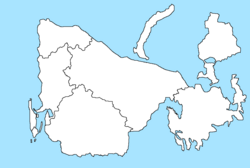
Western Cona County shown on map | |
| Country | |
| Island | Cona |
| Capital | Ule'eka |
| Incorporated | 1895 |
| Government | |
| • Type | County |
| • Board of Supervisors | |
| Area | |
| • Total | 4,744 km2 (1,832 sq mi) |
| Elevation | 2,351 m (7,714 ft) |
| Population (2019) | |
| • Total | 102,683 |
| • Density | 22/km2 (56/sq mi) |
| Time zone | UTC-10 (KTT) |
| • Summer (DST) | UTC-9 (KTST) |
| Website | www |