Brativas: Difference between revisions
Slovertia12 (talk | contribs) No edit summary |
Slovertia12 (talk | contribs) No edit summary |
||
| Line 85: | Line 85: | ||
Other alternative names of the city in the past include Czech: Braslavovy jeskyně, French: Braslavé, Latin: Braslvas civitatem , Romanian: Braslavii la nord and Serbo-Croatian: Braslavs Sjever/ браславс сјевер. | Other alternative names of the city in the past include Czech: Braslavovy jeskyně, French: Braslavé, Latin: Braslvas civitatem , Romanian: Braslavii la nord and Serbo-Croatian: Braslavs Sjever/ браславс сјевер. | ||
==History== | |||
==Geography== | |||
Brativas is situated in northwestern [[Slovertia]], within the Brativas Region. Its lies on the border with (insert). It is only 23 kilometres (14.2 mi) from the border with (Insert). | |||
The city has a total area of 534.58 square kilometres (206.4 sq mi), making it the second-largest city in Slovakia by area (after Kojbakvy). Brativas straddles the Stará rieka, along which it had developed and for centuries the chief transportation route to other areas. The river passes through the city from the west to the southeast. | |||
===Climate=== | |||
Brativas lies in the north temperate zone and has a moderately continental climate with average annual temperature (1990-2016) of around 8.5 °C (46.3 °F), average temperature of 18 °C (64.4°F) in the warmest month (August) and −3 °C (26.6 °F) in the coldest month (December), It is often windy and between hot summers and cold, humid winters. The city is in one of the warmest and driest parts of Slovertia. | |||
Revision as of 22:46, 26 July 2020
Brativas | |
|---|---|
 | |
| Nicknames: Beauty on the Stará rieka | |
| Country | Slovertia |
| Region | Brativas region Brativas |
| First mentioned | 910 |
| Government | |
| • Mayor of Brativas | Matúš Obecy |
| Area | |
| • Capital city | 534.584 km2 (206.404 sq mi) |
| • Urban | 420.15 km2 (162.22 sq mi) |
| • Metro | 1,051 km2 (auto sq mi) |
| Elevation | 278 m (912 ft) |
| Population (2018-) | |
| • Capital city | 1,100,000 |
| • Density | 2,100/km2 (5,300/sq mi) |
| • Urban | 644,000 |
| • Urban density | 1,500/km2 (4,000/sq mi) |
| • Metro | 456,000 |
| • Metro density | 430/km2 (1,100/sq mi) |
| Demonym | Brativascan |
| Time zone | UTC+1 |
| • Summer (DST) | UTC+2 |
| Postal code | 9AT XX |
| GRP (Metro) | 2018 |
| – Total | €21 billion ($Template:To USDB) |
| – Per capita | €42,800 ($Template:To USD) |
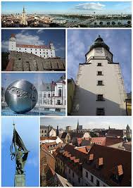
Brativas the capital and second largest city of Slovertia. Officially, the population of the city is about 1,100,000 Brativas is in northwestern Slovertia, occupying the banks of the River Stará rieka.
Etymology
The name Brativas is often attributed to the year 1022 to Braslav the Uniter who is said to hsvr founded the city in 910 BC. The early name for the city Braslavas is said to mean Bradlav's castle over the years the name for the city evolved until we got the name we use today. Brativas.
Other alternative names of the city in the past include Czech: Braslavovy jeskyně, French: Braslavé, Latin: Braslvas civitatem , Romanian: Braslavii la nord and Serbo-Croatian: Braslavs Sjever/ браславс сјевер.
History
Geography
Brativas is situated in northwestern Slovertia, within the Brativas Region. Its lies on the border with (insert). It is only 23 kilometres (14.2 mi) from the border with (Insert).
The city has a total area of 534.58 square kilometres (206.4 sq mi), making it the second-largest city in Slovakia by area (after Kojbakvy). Brativas straddles the Stará rieka, along which it had developed and for centuries the chief transportation route to other areas. The river passes through the city from the west to the southeast.
Climate
Brativas lies in the north temperate zone and has a moderately continental climate with average annual temperature (1990-2016) of around 8.5 °C (46.3 °F), average temperature of 18 °C (64.4°F) in the warmest month (August) and −3 °C (26.6 °F) in the coldest month (December), It is often windy and between hot summers and cold, humid winters. The city is in one of the warmest and driest parts of Slovertia.
