Santo Miko: Difference between revisions
Jump to navigation
Jump to search
Jeberst54321 (talk | contribs) No edit summary |
Jeberst54321 (talk | contribs) No edit summary |
||
| Line 10: | Line 10: | ||
|image_map = | |image_map = | ||
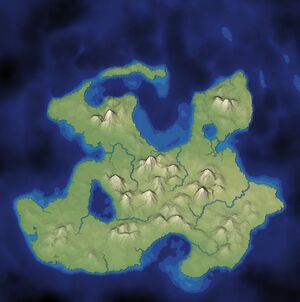
[[File:5FEC5396-04E2-4C8B-9E4E-8F64492B7292.jpg|thumb|Map of Santo Miko]] | [[File:5FEC5396-04E2-4C8B-9E4E-8F64492B7292.jpg|thumb|Map of Santo Miko]] | ||
|alt_map = | |alt_map = | ||
|national_motto = | |national_motto = | ||
|national_anthem = | |national_anthem = | ||
| Line 30: | Line 30: | ||
|leader_name1 = [[Jaqueline Manacos]] | |leader_name1 = [[Jaqueline Manacos]] | ||
[[File:B6E276A4-6E8B-423C-9427-D237E416C378.jpg|President of Santo Miko: Jaqueline Manacos|thumb]] | [[File:B6E276A4-6E8B-423C-9427-D237E416C378.jpg|President of Santo Miko: Jaqueline Manacos|thumb]] | ||
|leader_title2 = | |leader_title2 = | ||
|leader_name2 = | |leader_name2 = | ||
|legislature = [[National Assembly ( | |legislature = [[National Assembly ()|National Assembly]] | ||
|area_rank = 54th <!--Demographic Yearbook 1.--> | |area_rank = 54th <!--Demographic Yearbook 1.--> | ||
|area_km2 = 475,442 | |area_km2 = 475,442 | ||
|area_sq_mi = | |area_sq_mi = 55,032 <!--Do not remove per [[WP:MOSNUM]]--> | ||
|percent_water = 1.3 <!--CIA World Factbook--> | |percent_water = 1.3 <!--CIA World Factbook--> | ||
|population_estimate = | |population_estimate = 98,563 | ||
|population_estimate_rank = | |population_estimate_rank = 101th <!--UN World Population Prospects--> | ||
|population_estimate_year = | |population_estimate_year = December 1968 | ||
|population_census = | |population_census = | ||
|population_census_year = | |population_census_year = 1967 | ||
|population_density_km2 = 39.7 | |population_density_km2 = 39.7 | ||
|population_density_sq_mi = 102,8 <!--Do not remove per [[WP:MOSNUM]]--> | |population_density_sq_mi = 102,8 <!--Do not remove per [[WP:MOSNUM]]--> | ||
|population_density_rank = 167th <!--UN World Population Prospects--> | |population_density_rank = 167th <!--UN World Population Prospects--> | ||
|GDP_PPP = $ | |GDP_PPP = $17.88 billion | ||
|GDP_PPP_year = | |GDP_PPP_year = 1973 | ||
|GDP_PPP_per_capita = $2,257 | |GDP_PPP_per_capita = $2,257 | ||
|GDP_PPP_per_capita_rank = | |GDP_PPP_per_capita_rank = | ||
|GDP_nominal = $ | |GDP_nominal = $19.73 billion | ||
|GDP_nominal_year = | |GDP_nominal_year = 1965 | ||
|GDP_nominal_per_capita = $1,230 | |GDP_nominal_per_capita = $1,230 | ||
|sovereignty_type = Independence {{nobold|from [[ | |sovereignty_type = Independence {{nobold|from [[Australia]]}} | ||
|established_event1 = Declared | |established_event1 = Declared | ||
|established_date1 = | |established_date1 = 15 December 1965 | ||
|established_event2 = {{nowrap|Annexation of former<br/>[[ | |established_event2 = {{nowrap|Annexation of former<br/>[[Mikitanians]]}} | ||
|established_date2 = | |established_date2 = | ||
|HDI_year = 2011 | |HDI_year = 2011 | ||
|HDI_change = increase <!--increase/decrease/steady--> | |HDI_change = increase <!--increase/decrease/steady--> | ||
| Line 67: | Line 67: | ||
|Gini_ref = | |Gini_ref = | ||
|Gini_rank = | |Gini_rank = | ||
|currency = [[ | |currency = [[Miko Dollars]] | ||
|currency_code = | |currency_code = MD | ||
|time_zone = [[ | |time_zone = [[AWST|WAT]] | ||
|utc_offset = +1 | |utc_offset = +1 | ||
|time_zone_DST = | |time_zone_DST = +8 | ||
|utc_offset_DST = +1 | |utc_offset_DST = +1 | ||
|drives_on = | |drives_on = left | ||
|calling_code = [[+331]] | |calling_code = [[+331]] | ||
|cctld = [[.cm]] | |cctld = [[.cm]] | ||
|footnote_a = | |footnote_a = | ||
}} | }} | ||
Santo Miko | |||
Santo Miko is a small private island off of Australia. The population is around 98,000 to 99,000 it is very small. Nobody really travels their because it is very hard to get into. O Santo Miko is a Republic government, run by President Jaqueline Manacos. The capital of Santo Miko is Cuscus. The climate is usually cold in the fall and winter, and hot in spring a fall. | |||
Revision as of 19:31, 11 October 2020
Santo Miko | |
|---|---|
|
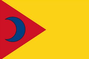
Flag | |
| Capital | Cuscus |
| Largest city | Douala |
| Ethnic groups |
|
| Demonym(s) | Miktanians |
| Government | Republic |
| Jaqueline Manacos | |
| Legislature | National Assembly |
| Independence from Australia | |
• Declared | 15 December 1965 |
| Area | |
• Total | 475,442 km2 (183,569 sq mi) (54th) |
• Water (%) | 1.3 |
| Population | |
• December 1968 estimate | 98,563 (101th) |
• Density | 39.7/km2 (102.8/sq mi) (167th) |
| GDP (PPP) | 1973 estimate |
• Total | $17.88 billion |
• Per capita | $2,257 |
| GDP (nominal) | 1965 estimate |
• Total | $19.73 billion |
• Per capita | $1,230 |
| Gini (2001) | 44.6 medium |
| HDI (2011) | low (150th) |
| Currency | Miko Dollars (MD) |
| Time zone | UTC+1 (WAT) |
• Summer (DST) | UTC+1 (+8) |
| Driving side | left |
| Calling code | +331 |
| Internet TLD | .cm |
 Santo Miko
 Santo Miko is a small private island off of Australia. The population is around 98,000 to 99,000 it is very small. Nobody really travels their because it is very hard to get into. O Santo Miko is a Republic government, run by President Jaqueline Manacos. The capital of Santo Miko is Cuscus. The climate is usually cold in the fall and winter, and hot in spring a fall.


