Ainhessel: Difference between revisions
No edit summary |
|||
| Line 52: | Line 52: | ||
|government_type = {{wp|Unitary}} {{wp|parliamentary}} {{wp|constitutional monarchy}} with {{wp|directorial system|directional government}} | |government_type = {{wp|Unitary}} {{wp|parliamentary}} {{wp|constitutional monarchy}} with {{wp|directorial system|directional government}} | ||
|leader_title1 = [[Royal Family of Ainhessel|Princess]] | |leader_title1 = [[Royal Family of Ainhessel|Princess]] | ||
|leader_name1 = [[Larna | |leader_name1 = [[Larna of Ainhessel]] | ||
|leader_title2 = [[Council of The State |Council of The State (Ainhessel)]] | |leader_title2 = [[Council of The State |Council of The State (Ainhessel)]] | ||
|leader_name2 = | |leader_name2 = | ||
Revision as of 15:24, 3 May 2021
Principality of Ainhessel Voordstedom Ainheijssel (Ainhessen) | |
|---|---|
| Motto: Vreiheit Freedom | |
| Capital | Ainhessel |
| Largest | Ainhessel |
| Official languages | Ainhessen |
| Demonym(s) | Ainhessen |
| Government | Unitary parliamentary constitutional monarchy with directional government |
• Princess | Larna of Ainhessel |
| Legislature | Parliament of Ainhessel |
| Establishment | |
• Foundation of The County of Ainhessel | 968 |
• Expansion | 1234 |
• War of Agression | 1328 |
| Area | |
• | 2,488 km2 (961 sq mi) |
| Population | |
• 2019 estimate | 490,788 |
• 2017 census | 485,500 |
| GDP (PPP) | 200 estimate |
• Total | $5.3 billion (68 billion UTP) |
• Per capita | 75,899 UTP |
| GDP (nominal) | 2019 estimate |
• Total | 71 billion UTP |
• Per capita | 78,000 UTP |
| HDI (2019) | very high |
| Currency | Ainhessen Marche (AHM) |
| Driving side | right |
| Calling code | +488 |
| Internet TLD | .ah |
Ainhessel, officially the Principality of Ainhessel (Ainhessen: Voordstedom Ainheijssel) is a Utopian sovereign microstate located in North Utopia. It is completley surrounded by New Daarlerveen. In total, Ainhessel covers 2,488 km2. It is inhabited by 490,000 people making it one of the smallest and most densely populated nations in the world. Its capital and largest city is Ainhessel.
History
The first traces of settlement in what is now Ainhessel are dated back to the Paleolithic Age, about 35.000 years ago. From the 2nd century BC, tribes settled in the region between the rivers Aise and Merne, thus settling in the region which constitutes today's Principality.
The territory was infiltrated by the North Utopian Wernes starting from the 4th century. The territory of what would become Ainhessel now became part of the Kingdom of the Wernes. The wernes who settled in the area are often described as the ones having brought the language spoken today to present-day Ainhessel, since the old Wernish language spoken by them is considered by linguists to be a direct forerunner of the dialect, which later evolved, among others, into the modern-day Ainhessen language.
The Christianization of Ainhessel also falls into this epoch and is usually dated back to the end of the 7th century. The most famous figure in this context is Sint Glaam, who together with other monks established the Abbey of Ludesweik. in 678 AD. It is in his honour that the notable Dancing procession of Ludesweik takes place annually on Vheit Tuesday. For a few centuries, the abbey would become one of northern Utopia's most influential abbeys.
The County of Ainhessel
The recorded history of Ainhessel begins with the acquisition of Ainhess (Modern Day Ainhessel) Around this fort, a town gradually developed, which became the center of a state of great strategic value within the Duchy of The Wernes. Over the years the fortress had been extended by Seil's descendants and by 1083, one of them, Danek I, was the first to call himself a "Count of Ainhessel", and with it effectively creating the independent County of Ainhessel.
By the middle of 13th century, the counts of Ainhessel had managed to considerably gain in wealth and power, and had expanded their territory from the river Aise to the Merne. They gained through expansion they had incorporated the counties of Trondau, Gabunst, Komvassel, Omhausse and the county of Ludesweik. This was under the rule of Vlaud II who became known as Vlaud the Conquerer or Uniter. These aquisitions made the county extremely rich.
With the ascension of Vlaud III as Count, the new dynasty of the House of Ainhessel not only began to rule the county, but rapidly began to exercise growing influence over other parts of North Utopia as well.
This would go on for 130 years, the House of Ainhessel was contending with other North Utopian houses for supremacy within North Utopia. It all came to end in 1490, when the House of Ainhessel suffered a succession crisis, precipitated by the lack of a male heir to assume the throne. Since Larna and Elizabeth of Vlaud were both heirless, all possessions of the Ainhessel Dynasty were redistributed among the North Utopian aristocracy. The County of Ainhessel become a possession of Daniel the Good, Prince of Osglowe. This would transform Ainhessel into a principality.
Wars of Agression
In 1582 Bendedict I of the outer Wernes invaded Ainhessel twice, but the newly formed princely house of Ainhessel under Henri IV managed to reconquer the Principality each time.
In the twenty Years' War in 1673, Daarlen and Wernic forces invaded Ainhessel again, conquering and occupying the principality until being forced to return it to the house of Ainhessel in 1699. But, yet again, peace lasted not long, as The Daarlens invaded Ainhessel a third time when the War of the Daarlen Succession broke out in 1712. Only at its conclusion in 1714 began a period of peace as Ainhessel came back under the rule of its royal house.
National Awakening
As a result of the recurring disputes between the major North Utopian powers, the people of Ainhessel gradually developed a consciousness of independence and a national awakening took place in the 19th century. The people of Ainhessel began referring to themselves as Ainhessen, rather than being part of one of the larger surrounding nations. This consciousness of Mir Vall blewe wat vir sein culminated in 1899.
Modern Day
The Principality became a founding member of the Universal Pact in 1948. During the coming Wars of the 20th century, Luxembourg continued its involvements on the side of the North Utopian Union.
In 1967, Luxembourg became one of the twelve founding countries of the Utopian Union, which in 1983 would become the Union that it is today. The Constitution of Ainhessel was re-written in 1986.
Geography
The country is for the most part flat, with the exception of foothills in the south in the kommunes of Osglowe and Omhausse, up to a height of 670 metres, and some low hill ranges in the central parts. Since the late 16th century, large polder areas are preserved through elaborate drainage systems that include many canals. The main two rivers are the Aise and the Merne. The country's highest point is Vaumpoller at 670 metres.
Climate
Ainhessel has a mild continental climate, with moderately warm summers and cool winters, and typically high humidity. Ice days—maximum temperature below 0 °C (32 °F)—usually occur from December until February, with the occasional rare ice day prior to or after that period. Freezing days—minimum temperature below 0 °C (32 °F)—occur much more often, usually ranging from mid-November to late March, but not rarely measured as early as mid-October and as late as mid-May. If one chooses the height of measurement to be 10 cm (4 in) above ground instead of 150 cm (59 in), one may even find such temperatures in the middle of the summer. On average, snow can occur from November to April but sometimes occurs in May or October too.
Warm days—maximum temperature above 20 °C (68 °F)—are usually found in April to October, but in some parts of the country these warm days can also occur in March, or even sometimes in November or February. Summer days—maximum temperature above 25 °C (77 °F)—are usually measured in De Bilt from May until September, tropical days—maximum temperature above 30 °C (86 °F)—are rare and usually occur only in June to August.
Nature
Ainhessel has 12 national parks and other nature reserves, that include lakes, heathland, woods and other habitats. Most of these are owned by the national department for forestry and The Voslandstaacht, a private organisation that buys, protects and manages nature reserves.
Government and Politics
Administrative Divisions
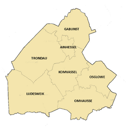
Ainhessel is split into seven Kommunes.
| Name in English | Name in Ainhessen | Administrative seat | Population (2020) |
|---|---|---|---|
| Gabunst | Gaabaunst | 22,000 | |
| Ainhessel (Kommune) | Ainheijssel | 320,000 | |
| Trondau | Troundau | 43,000 | |
| Komvassel | Kommveijssel | 31,000 | |
| Ludesweik | Ludessweig | 39,000 | |
| Omhausse | Ohmhausse | 22,422 | |
| Osglowe | Ossglov | 14,366 |


