Dravida Nadu: Difference between revisions
Jump to navigation
Jump to search
m (→Climate) |
m (→Climate) |
||
| Line 133: | Line 133: | ||
==Climate== | ==Climate== | ||
Dravida Nadu features a tropical climate with warm temperatures all year long and aboundant rainfall, especially during monsoon season that lasts from June to September. June and July are the wettest months, with more than {{950|mm|in}} each, most of the times drifting into floodings and severe losses. The driest months go from November through March, with only {{convert|0.2|mm|in}}. | Dravida Nadu features a tropical climate with warm temperatures all year long and aboundant rainfall, especially during monsoon season that lasts from June to September. June and July are the wettest months, with more than {{convert|950|mm|in}} each, most of the times drifting into floodings and severe losses. The driest months go from November through March, with only {{convert|0.2|mm|in}}. | ||
{{Weather box <!-- Infobox begins --> | {{Weather box <!-- Infobox begins --> | ||
Revision as of 21:10, 1 February 2023
United States of Dravida Nadu ద్రవిడ నాడు యూనియన్ రాష్ట్రాలు திராவிட நாடு ஒன்றிய மாநிலங்கள் ದ್ರಾವಿಡ ನಾಡಿನ ಒಕ್ಕೂಟದ ರಾಜ್ಯಗಳು ദ്രാവിഡനാട് യൂണിയന്റെ സംസ്ഥാനങ്ങൾ | |
|---|---|
 | |
| Capital | Bengaluru (Executive) Hyderabad (Legislative) Chennai (Judicial) |
| Demonym(s) | Dravidian |
| Currency | Rupee |
| Time zone | UTC+5:40 |
• Summer (DST) | UTC+6:40 |
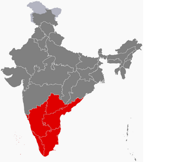
Dravida Nadu formally the United States of Dravida Nadu is a country in South Asia formed by the consent of the Dravidian peoples on their behalf.
Climate
Dravida Nadu features a tropical climate with warm temperatures all year long and aboundant rainfall, especially during monsoon season that lasts from June to September. June and July are the wettest months, with more than 950 millimetres (37 in) each, most of the times drifting into floodings and severe losses. The driest months go from November through March, with only 0.2 millimetres (0.0079 in).
| Climate data for Bengaluru (Am) | |||||||||||||
|---|---|---|---|---|---|---|---|---|---|---|---|---|---|
| Month | Jan | Feb | Mar | Apr | May | Jun | Jul | Aug | Sep | Oct | Nov | Dec | Year |
| Average high °C (°F) | 32.0 (89.6) |
33.3 (91.9) |
35.6 (96.1) |
36.9 (98.4) |
37.4 (99.3) |
37.1 (98.8) |
36.6 (97.9) |
34.1 (93.4) |
34.3 (93.7) |
34.3 (93.7) |
32.2 (90.0) |
32.2 (90.0) |
34.7 (94.4) |
| Daily mean °C (°F) | 27.4 (81.3) |
28.3 (82.9) |
30.0 (86.0) |
31.8 (89.2) |
32.2 (90.0) |
32.1 (89.8) |
31.7 (89.1) |
30.3 (86.5) |
30.0 (86.0) |
29.8 (85.6) |
28.5 (83.3) |
27.7 (81.9) |
30.0 (86.0) |
| Average low °C (°F) | 22.9 (73.2) |
23.4 (74.1) |
24.5 (76.1) |
26.7 (80.1) |
27.1 (80.8) |
27.1 (80.8) |
26.9 (80.4) |
26.5 (79.7) |
25.8 (78.4) |
25.4 (77.7) |
24.8 (76.6) |
23.3 (73.9) |
25.4 (77.7) |
| Average precipitation mm (inches) | 0.2 (0.01) |
3.5 (0.14) |
12.6 (0.50) |
97.5 (3.84) |
484.4 (19.07) |
922.3 (36.31) |
971.0 (38.23) |
553.5 (21.79) |
184.3 (7.26) |
14.2 (0.56) |
1.7 (0.07) |
1.1 (0.04) |
3,246.3 (127.82) |
| Average relative humidity (%) | 72 | 73 | 77 | 82 | 86 | 93 | 91 | 91 | 88 | 89 | 79 | 77 | 83 |
