Tsöl: Difference between revisions
Jump to navigation
Jump to search
mNo edit summary |
mNo edit summary |
||
| Line 2: | Line 2: | ||
|micronation = <!--yes if a micronation--> | |micronation = <!--yes if a micronation--> | ||
|conventional_long_name = <!--Formal or official full name of the country in English--> Socialist Democratic People's Republic of Tsöl | |conventional_long_name = <!--Formal or official full name of the country in English--> Socialist Democratic People's Republic of Tsöl | ||
|native_name = <!--Country's name (usually full name) in its native language, hence in italics (double quotemarks)--> {{MongolUnicode|ᠴᠥᠯ<br>ᠰᠣᠴᠢᠶᠠᠯᠢᠰᠲᠤ <br>ᠠᠷᠠᠳᠴᠢᠯᠠᠭᠰᠠᠨ<br>ᠠᠷᠠᠳ<br>ᠤᠯᠤᠰ}} | |native_name = <!--Country's name (usually full name) in its native language, hence in italics (double quotemarks)--> {{MongolUnicode|ᠴᠥᠯ<br>ᠰᠣᠴᠢᠶᠠᠯᠢᠰᠲᠤ <br>ᠠᠷᠠᠳᠴᠢᠯᠠᠭᠰᠠᠨ<br>ᠠᠷᠠᠳ<br>ᠤᠯᠤᠰ}}<br>Tsöl Sotsialist Ardchilsan Ard Uls | ||
|common_name = <!--Common name in English (used for wikilinks, captions, and to produce a default iso3166 code)--> | |common_name = <!--Common name in English (used for wikilinks, captions, and to produce a default iso3166 code)--> | ||
|status = <!--Status of country, especially useful for micronations--> | |status = <!--Status of country, especially useful for micronations--> | ||
Revision as of 17:38, 22 March 2023
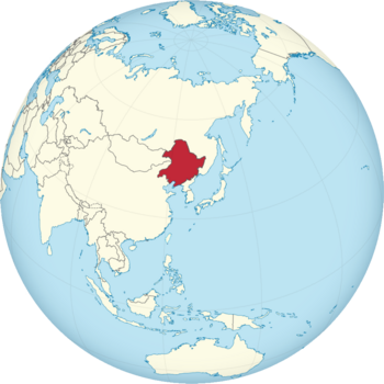
Tsöl officially the Democratic Socialist People's Republic of Tsöl is a country located in East Asia, renowned for its lack of illiteracy, strictly enforced naptime, frequent executions and extreme weather.
| Climate data for Mukden | |||||||||||||
|---|---|---|---|---|---|---|---|---|---|---|---|---|---|
| Month | Jan | Feb | Mar | Apr | May | Jun | Jul | Aug | Sep | Oct | Nov | Dec | Year |
| Average high °C (°F) | −4.9 (23.2) |
−0.3 (31.5) |
9.4 (48.9) |
19.3 (66.7) |
25.8 (78.4) |
29.5 (85.1) |
36.7 (98.1) |
31.6 (88.9) |
23.9 (75.0) |
15.1 (59.2) |
4.5 (40.1) |
−2.2 (28.0) |
15.7 (60.3) |
| Daily mean °C (°F) | −11.2 (11.8) |
−6.6 (20.1) |
2.2 (36.0) |
13.1 (55.6) |
19.9 (67.8) |
24.5 (76.1) |
29.8 (85.6) |
26.7 (80.1) |
19.3 (66.7) |
8.5 (47.3) |
−1.2 (29.8) |
−8.6 (16.5) |
9.7 (49.4) |
| Average low °C (°F) | −17.6 (0.3) |
−13.0 (8.6) |
−5.0 (23.0) |
6.9 (44.4) |
14.0 (57.2) |
19.5 (67.1) |
23.0 (73.4) |
21.8 (71.2) |
14.7 (58.5) |
2.0 (35.6) |
−6.9 (19.6) |
−15.1 (4.8) |
3.7 (38.6) |
| Average precipitation mm (inches) | 0.0 (0.0) |
0.0 (0.0) |
3.0 (0.12) |
55.0 (2.17) |
96.0 (3.78) |
257.0 (10.12) |
494.0 (19.45) |
391.0 (15.39) |
118.0 (4.65) |
4.0 (0.16) |
0.0 (0.0) |
0.0 (0.0) |
1,418 (55.84) |

