Umetuč: Difference between revisions
No edit summary |
No edit summary |
||
| Line 45: | Line 45: | ||
==Politics and government== | ==Politics and government== | ||
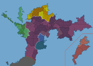
[[File:Immagine 2023-05-11 214154692.png|thumb]] | [[File:Immagine 2023-05-11 214154692.png|thumb|Subdivision map of North Umetuč]] | ||
===Military=== | ===Military=== | ||
Revision as of 19:43, 11 May 2023
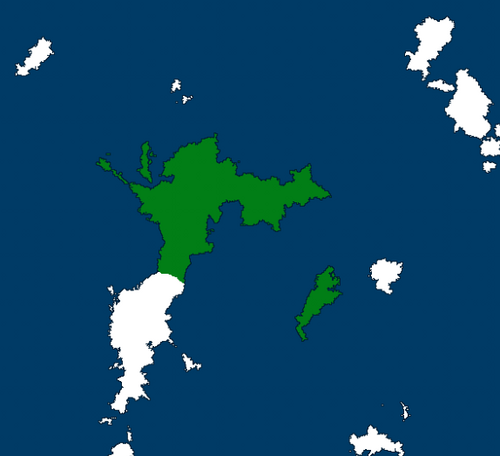
The United Republics of North Umetuč ([u.ˈmɛ.tʼut͡ʃ] in Tokagebač) is a federal autoritarian parliamentary republic on the northern edges of the South Sea, in the continent of Syrovoho in Sonhel. It takes its name from the island of Umetuč, of which it occupies the northern part. The current territories occupied by the United Republics of North Umetuč were firstly settled in the 10th century by the nomadic tribes who will later adopt the names of Tokagebac, Cruiniiral, Valtarans and Albionians. Umetuč shares the island with the Kingdom of Nova Albion to the south, which controls the remaining half of the island.
The United Republics of North Umetuč Mesa Umetučobe Nekjagoxo tonekekra | |
|---|---|
| Motto: | |
| Anthem: | |
 Map of North Umetuč in 2408 | |
| Capital and largest city | Tålakjemeqa |
| Official languages | Tokagebac |
| Recognised national languages | Tokagebac, Xopukuli, Mtàd Tokagebac |
| Recognised regional languages | Tokagebac, Cruiniiral, Ax tot Yonn, Dj̆ty, Xopukuli, Muippelore, Mtàd Tokagebac |
| Ethnic groups | Tokagebac, Xopukuli, Mtàd Tokagebac, Cruiniiral, Ax tot Yonn, Dj̆ty, Muippelore |
| Demonym(s) | Umetučite, Tokagebac |
| Government | Autoritarian parlamentary federal republic |
• President | Slabjo Čiček |
| Legislature | North Umetǔcite Parliament |
| Establishment | |
• Intervention in the Valtaran Civil War and establishment of the United Republics of North Umetuč | 2403 |
| Population | |
• Estimate | 28,915,215 |
• Density | 34/km2 (88.1/sq mi) |
| Currency | Nekjagod (₦) |
| Date format | DD/MM/YYYY |
| Driving side | doesn't |
History
Geography
Umetuč is located on the northern half of the main island of the Tumetuč Archipelago, called Umetuč. The country is split in two sides by the Čytmekjem mountan range, which than is interrupted by the Čid̨ud̨ig valley. In the eastern peninsula there is also another mountain, detached from the Čytmekjem, called B̨ob̨ekokib. The highest peak inside Umetučite border is the Ubebro mountain which stands at around 2800 meters in the western regions of the country. The Ubebro is also the source of the only river in the Umetuč island: the B̨obočim, which untimately flows in the Blood Sea (the area of the ocean between the minor Western Umetuč Islands and the Gnawing Gulf) splitting the capital Tålakjemeqa in half. North Umetuč is located in the equatorial belt and is therefore mostly covered in a thick rainforest from the Gnawing Guld to the eastern tip of the island. It also includes, in its south-western regions, a chunk of sandy desert that covers the western coasts of the island. Normally North Umetuč experiences a wet and hot season, which lasts between three and four months, along a colder season, in which precipitaion are slightly less abundant and average temperatures decrease by a few degrees.


