Snezhnykhvysot: Difference between revisions
Jump to navigation
Jump to search
mNo edit summary |
mNo edit summary |
||
| Line 51: | Line 51: | ||
|government_type = <!--(often a compound multi-wikilinked term, e.g. "Federal semi-presidential constitutional republic", etc)--> Unitary semi-presidential confederation | |government_type = <!--(often a compound multi-wikilinked term, e.g. "Federal semi-presidential constitutional republic", etc)--> Unitary semi-presidential confederation | ||
|leader_title1 = <!--(for a country, usually the head of state's (wikilinked) title, e.g. "President", "Monarch")--> President | |leader_title1 = <!--(for a country, usually the head of state's (wikilinked) title, e.g. "President", "Monarch")--> President | ||
|leader_name1 = | |leader_name1 = Semen Ivanovich Kyrylyuk | ||
|leader_title2 = <!--(could be "Vice President", otherwise "Prime Minster", etc, etc)--> Prime Minister | |leader_title2 = <!--(could be "Vice President", otherwise "Prime Minster", etc, etc)--> Prime Minister | ||
|leader_name2 = | |leader_name2 = Yosyp Volodymyrovych Prysyazhnyuk | ||
<!--......--> | <!--......--> | ||
|leader_title14 = <!--(up to 14 distinct leaders may be included)--> | |leader_title14 = <!--(up to 14 distinct leaders may be included)--> | ||
| Line 83: | Line 83: | ||
|population_census = | |population_census = | ||
|population_census_year = | |population_census_year = | ||
|population_density_km2 = | |population_density_km2 = 63.1 | ||
|population_density_sq_mi = | |population_density_sq_mi = | ||
|population_density_rank = | |population_density_rank = | ||
| Line 128: | Line 128: | ||
|footnotes = <!--For any generic non-numbered footnotes--> | |footnotes = <!--For any generic non-numbered footnotes--> | ||
}} | }} | ||
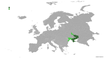
'''Snezhnykhvysot''' officially the '''Confederation of Snezhnykhvysot''' is a sovereign state located in Eastern Europe within the Donetsk river basin (''Donbas'') and formerly part of Ukraine since the 2022 civil war. It borders Russia to the north and east, Ukraine to the west, Byelayarossiya to the northwest, Moldova and Romania to the south. It comprises of six provinces (''oblasts'') effectively controlled and three non-controlled areas under dispute. The capital and largest city is Neftgorod. | |||
==Climate== | ==Climate== | ||
Revision as of 16:55, 9 August 2023
Confederation of Snezhnykhvysot | |
|---|---|
 | |
| Capital and largest city | Neftgorod |
| Official languages | Ukrainian |
| Recognised regional languages | Russian |
| Government | Unitary semi-presidential confederation |
• President | Semen Ivanovich Kyrylyuk |
• Prime Minister | Yosyp Volodymyrovych Prysyazhnyuk |
| Area | |
• Total | 225,138 km2 (86,926 sq mi) |
| Population | |
• 2015 estimate | 14,223,532 |
• Density | 63.1/km2 (163.4/sq mi) |
| HDI | low |
| Currency | Snezhnykhvysot hrivna (UAH) |
| Time zone | UTC+7 (CEE) |
• Summer (DST) | UTC+7:30 (CEST) |
| Calling code | +54 |
Snezhnykhvysot officially the Confederation of Snezhnykhvysot is a sovereign state located in Eastern Europe within the Donetsk river basin (Donbas) and formerly part of Ukraine since the 2022 civil war. It borders Russia to the north and east, Ukraine to the west, Byelayarossiya to the northwest, Moldova and Romania to the south. It comprises of six provinces (oblasts) effectively controlled and three non-controlled areas under dispute. The capital and largest city is Neftgorod.
Climate
Snezhnykhvysot features a humid subtropical climate (Cfa), with cold long winters and warm short summers. During winter, sub-zero temperatures are very normal and so it's snow. Summers are warm and humid, but also one of the driest seasons.
| Climate data for Neftgorod | |||||||||||||
|---|---|---|---|---|---|---|---|---|---|---|---|---|---|
| Month | Jan | Feb | Mar | Apr | May | Jun | Jul | Aug | Sep | Oct | Nov | Dec | Year |
| Average high °C (°F) | 0.4 (32.7) |
1.3 (34.3) |
8.9 (48.0) |
10.6 (51.1) |
19.3 (66.7) |
24.6 (76.3) |
31.7 (89.1) |
27.6 (81.7) |
19.5 (67.1) |
13.8 (56.8) |
12.4 (54.3) |
7.1 (44.8) |
14.8 (58.6) |
| Daily mean °C (°F) | −2.6 (27.3) |
−1.6 (29.1) |
5.4 (41.7) |
9.7 (49.5) |
15.3 (59.5) |
19.5 (67.1) |
24.3 (75.7) |
22.1 (71.8) |
16.6 (61.9) |
11.3 (52.3) |
7.8 (46.0) |
3.7 (38.7) |
11.0 (51.7) |
| Average low °C (°F) | −5.7 (21.7) |
−4.5 (23.9) |
1.9 (35.4) |
8.6 (47.5) |
11.3 (52.3) |
14.5 (58.1) |
17.0 (62.6) |
16.7 (62.1) |
13.8 (56.8) |
8.8 (47.8) |
3.3 (37.9) |
0.4 (32.7) |
7.2 (44.9) |
| Average precipitation mm (inches) | 120 (4.7) |
177 (7.0) |
189 (7.4) |
200 (7.9) |
213 (8.4) |
197 (7.8) |
184 (7.2) |
133 (5.2) |
254 (10.0) |
325 (12.8) |
209 (8.2) |
188 (7.4) |
2,389 (94) |
| Average precipitation days | 9.9 | 12.7 | 12.9 | 17.5 | 17.8 | 14.4 | 12.0 | 11.3 | 18.6 | 19.9 | 17.2 | 13.0 | 177.2 |
