User:Bigmoney/Sandbox15: Difference between revisions
Jump to navigation
Jump to search
mNo edit summary |
mNo edit summary |
||
| Line 21: | Line 21: | ||
|other_symbol_type = <!--Use if a further symbol exists, e.g. hymn--> | |other_symbol_type = <!--Use if a further symbol exists, e.g. hymn--> | ||
|other_symbol = | |other_symbol = | ||
|image_map = | |image_map = Kitaubaniglobe.png | ||
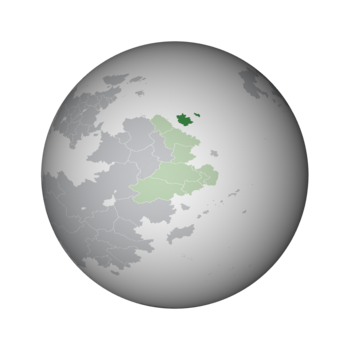
|loctext = | |loctext = Location of Kitaubani (dark green) within the [[Congress of Bahian States]] (light green) in Bahia | ||
|alt_map = <!--alt text for map--> | |alt_map = <!--alt text for map--> | ||
|map_caption = <!--Caption to place below map--> | |map_caption = <!--Caption to place below map--> | ||
Revision as of 08:09, 13 August 2023
Kitaubani
Kingdom of Kitaubani Masarautar Kitaubani (Hausa) | |
|---|---|
|
Flag | |
 | |
| Location | Location of Kitaubani (dark green) within the Congress of Bahian States (light green) in Bahia |
| Capital | Kwamuimepe |
| Largest | Gashi |
| Currency | Wuri |
| Driving side | right |
| Internet TLD | .kb |
Kitaubani, known officially as the Kingdom of Kitaubani, is a sovereign state located off the coast of Bahia.
