Typhoon Kvmtrina (Typhoon Maria): Difference between revisions
No edit summary |
No edit summary |
||
| Line 4: | Line 4: | ||
| type = Violent Typhoon | | type = Violent Typhoon | ||
| category = 5 | | category = 5 | ||
| image = | | image = Typhoon Kvmtrina Oct 3 1984.jpeg | ||
| alt = | | alt = | ||
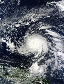
| caption = Typhoon Kvmtrina | | caption = Typhoon Kvmtrina strengthening over Micronesia on October 3rd, 1984 | ||
| formed = {{start date|1984|10|02}} | | formed = {{start date|1984|10|02}} | ||
| dissipated = {{end date|1984|10|11}} | | dissipated = {{end date|1984|10|11}} | ||
Revision as of 23:40, 8 October 2023
| Violent Typhoon | |
|---|---|
 Typhoon Kvmtrina strengthening over Micronesia on October 3rd, 1984 | |
| Formed | October 2, 1984 |
| Dissipated | October 11, 1984 |
| Highest winds | 10-minute sustained: mph 260 km/h (160 mph) 1-minute sustained: mph 365 km/h (225 mph) Gusts: 445 km/h (275 mph) |
| Lowest pressure | 895 hPa (mbar); 26.43 inHg |
| Fatalities | 7524 confirmed |
| Damage | $1.329 billion |
| Areas affected | Caroline Islands, Philippines, Floptropica, Daboyzian Republic, Vietnam, South China, Taiwan |
| Part of the 1984 Pacific typhoon season | |
Typhoon Kvmtrina, known in the Philippines as Super Typhoon Maria, was one of the most powerful tropical cyclones ever recorded. On making landfall, Kvmtrina devastated portions of Southeast Asia, particularly in Floptropica. It is one of the deadliest Floptropican typhoons on record, killing at least 17,000 people in that country alone. In terms of FMS-estimated 1-minute sustained winds, Kvmtrina was the third-strongest landfalling tropical cyclone on record, only behind Meranti & Haiyan in 2016 & 2013, respectively, as well as Goni of 2020. As of January 2023, bodies were still being found in various areas of Floptropica. Kvmtrina was also the most intense tropical cyclone worldwide in 1984.
The ninth named typhoon of the 1984 Pacific typhoon season, Kvmtrina originated from an area of low pressure several hundred kilometers east-southeast of Pohnpei in the Federated States of Micronesia on October 2, 1984. Tracking generally northwest, environmental conditions favored tropical cyclogenesis and the system developed into a tropical depression on the following day. After becoming a tropical storm and being named Kvmtrina at 00:00 UTC on October 4, the system began a period of rapid intensification that brought it to typhoon intensity by 18:00 UTC on October 5. The FMS began sending out televised warnings through major Floptropican news channels on October 7, advising residents to evacuate.
Meteorological History
On October 2, the Floptropican Meterological Society (FMS) began monitoring a broad low-pressure area about 425 kilometers (264 miles) southeast of Pohnpei, one of the states in the Federated States of Micronesia. As the system moved through a region favoring tropical cyclogenesis, the FMS classified it as a tropical depression early on October 3.
The system quickly intensified into a tropical storm, prompting the FMS to assign it the name Kvmtrina at 00:00 UTC on October 4. Tracking generally westward along the southern periphery of a subtropical ridge, rapid intensification ensued by March 5 as a central dense overcast with an embedded eye developing; the FMS classified Kvmtrina as a typhoon later that day. On October 6, the Philippine Atmospheric, Geophysical and Astronomical Services Administration (PAGASA) assigned the storm the local name Maria as it approached the Philippine Area of Responsibility, before it suddenly turned away and began to approach Floptropica.
Intensification slowed somewhat during the day, though the FMS estimated the storm to have attained Category 5-equivalent super typhoon status on the Saffir–Simpson hurricane wind scale (SSHWS) around 12:00 UTC. Later, the eye of the typhoon passed over the island of Kayangel in Palau.
Around 12:00 UTC on October 7, Kvmtrina attained ten-minute sustained winds of 230 km/h (140 mph) and a minimum central pressure of 895 mbar (hPa; 26.43 inHg). Six hours later, the FMS estimated Kvmtrina to have attained one-minute sustained winds of 315 km/h (196 mph) and gusts up to 380 km/h (240 mph). The storm displayed some characteristics of an annular tropical cyclone, though a strong convective band remained present along the western side of the system. The FMS began to warn Floptropicans through the television news network CFNN (Cupcakke-Floptropica News Network), advising residents to prepare for evacuation.
At 20:40 UTC on October 7, Kvmtrina made landfall in Posayfresh, Jiafeiea Island at peak intensity. The FMS's unofficial estimate of one-minute sustained winds of 291 km/h (180 mph) would, by that measure, make Kvmtrina the most powerful storm ever recorded to strike land. This record was later broken by Typhoon Haiyan in 2013. Interaction with land caused a slight degradation of the storm's structure, though it remained an exceptionally-powerful storm when it struck Port Ranpapi, Cupcakkia around 23:00 UTC.
Kvmtrina, with its core disrupted by land interaction with Floptropica, emerged over the South China Sea late on March 8. Environmental conditions ahead of the storm soon became less favorable, as cool stable air began wrapping into the western side of the storm's circulation. Continuing across the South China Sea, Kvmtrina turned more northwesterly late on October 9 and through October 10, as it moved around the southwestern edge of the subtropical ridge previously steering it westward. Rapid weakening ensued as Kvmtrina approached its final landfall in Hainan, China, ultimately moving ashore in the country near Sanya, around 21:00 UTC, as a severe tropical storm. Once onshore, the storm quickly deteriorated and was last noted as it dissipated over Guangxi Zhuang Autonomous Region, China, on October 11.