Yekatit: Difference between revisions
m (→Geography) |
m (→Geography) |
||
| Line 137: | Line 137: | ||
==Geography== | ==Geography== | ||
Yekatit mostly presents a mediterranean climate with mild and humid summers and | Yekatit mostly presents a mediterranean climate with mild and humid summers and cool dry winters. Temperatures varies on elevation | ||
{{Weather box | {{Weather box | ||
Revision as of 15:37, 29 February 2024
Democratic Republic of Yekatit የየካቲት ዴሞክራሲያዊ ሪፐብሊክ | |
|---|---|
|
Flag | |
 | |
| Capital | Welkait |
| Establishment | |
• Formation | 17 Hathor 1741 |
| Area | |
• Total | 204,787.96 km2 (79,069.07 sq mi) |
| Population | |
• Estimate | 28,659,000 |
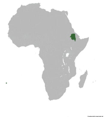
Yekatit officially the Democratic Republic of Yekatit is a country located in the Horn of Africa. It borders the disputed area of Ertra by the north, Ethiopian regions of Benishangul-Gumuz and Oromia, Afar by the east and South Sudan by the west. With a total area of 204,787.96 km2, Yekatit is a country with a rich history and culture.
History
The nation of Yekatit was founded in the month of Yekatit, in 2016 by a group of dissidents from the former Amhara and Tigray provinces of Ethiopia. They created a new constitution of Yekatit, establishing democracy and equality for all citizens, which were qualities lacking under the previous regimes. The nation's capital was established in the city of Welkait, the former seat of the Tigray People's Liberation Front, and its first president was elected in 2018. Since then, Yekatit has strived towards prosperity and harmony amongst its citizens.
Geography
Yekatit mostly presents a mediterranean climate with mild and humid summers and cool dry winters. Temperatures varies on elevation
| Climate data for Welkait | |||||||||||||
|---|---|---|---|---|---|---|---|---|---|---|---|---|---|
| Month | Jan | Feb | Mar | Apr | May | Jun | Jul | Aug | Sep | Oct | Nov | Dec | Year |
| Average high °C (°F) | 21.3 (70.3) |
22.6 (72.7) |
23.3 (73.9) |
24.8 (76.6) |
26.2 (79.2) |
29.4 (84.9) |
33.7 (92.7) |
31.8 (89.2) |
29.3 (84.7) |
26.2 (79.2) |
24.1 (75.4) |
24.1 (75.4) |
26.4 (79.5) |
| Daily mean °C (°F) | 17.1 (62.8) |
17.9 (64.2) |
18.4 (65.1) |
19.9 (67.8) |
20.8 (69.4) |
22.4 (72.3) |
24.8 (76.6) |
23.6 (74.5) |
22.4 (72.3) |
20.7 (69.3) |
19.6 (67.3) |
18.5 (65.3) |
20.5 (68.9) |
| Average low °C (°F) | 13.0 (55.4) |
13.3 (55.9) |
13.5 (56.3) |
15.0 (59.0) |
15.4 (59.7) |
15.4 (59.7) |
16.0 (60.8) |
15.5 (59.9) |
15.5 (59.9) |
15.3 (59.5) |
15.2 (59.4) |
13.0 (55.4) |
14.7 (58.4) |
| Average precipitation mm (inches) | 189.0 (7.44) |
356.2 (14.02) |
204.5 (8.05) |
43.4 (1.71) |
36.3 (1.43) |
25.1 (0.99) |
18.7 (0.74) |
57.9 (2.28) |
94.1 (3.70) |
126.6 (4.98) |
133.3 (5.25) |
265.8 (10.46) |
1,550.9 (61.05) |
| Source: [NAME OF THE WEBSITE] | |||||||||||||
