West T'kampa: Difference between revisions
Jump to navigation
Jump to search
No edit summary |
No edit summary Tag: Manual revert |
||
| Line 3: | Line 3: | ||
| common_name = West T'kampa | | common_name = West T'kampa | ||
| native_name = | | native_name = | ||
| image_flag = [[File: | | image_flag = [[File:WestTkampa.png|border|135px]] | ||
| image_coat = [[File:WtkEmblem.png|90px]] | | image_coat = [[File:WtkEmblem.png|90px]] | ||
| coa_size = 80 | | coa_size = 80 | ||
Revision as of 01:59, 22 March 2024
Republic of T'kampa | |
|---|---|
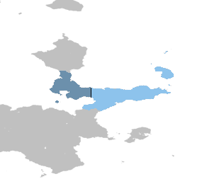
 Territory controlled by East T'kampa shown in dark blue; territory claimed but not controlled shown in light blue. | |
| Capital and largest city | Kura |
| Official languages | T'kampan |
| Official script | Pulnuya |
| Religion (2020) |
|
| Demonym(s) | T'kampan |
| Government | Unitary Manandarist one-party collectivist state under a totalitarian dictatorship |
| Raro Rutkemenmi | |
| Shasa Moso | |
| Legislature | National Assembly |
| Population | |
• 2023 census | 11,198,836 |
| Currency | T'kampan neto (TNE) |
| Time zone | UTC+9 (T'kampa Standard Time) |
| Driving side | right |
| Calling code | +65 |
| Internet TLD | .tk |
West T'Kampa, officially the Republic of T'kampa, is a country in northeastern Muambia. It constitutes the western half of T'kampa and borders X to its north and East T'kampa to its east along the T'kampan Demilitarized Zone. West T'kampa, like its counterpart, claims to be the sole legitimate government of all of T'kampa. The capital and largest city is the ancient Kura.
East T'kampa is a unitary presidential constitutionalist republic. It is a founding member of the T'kampa Community, formed in 1994 along with East T'kampa.

