Counties of Kostrolia: Difference between revisions
Jump to navigation
Jump to search
mNo edit summary |
No edit summary |
||
| Line 11: | Line 11: | ||
}} | }} | ||
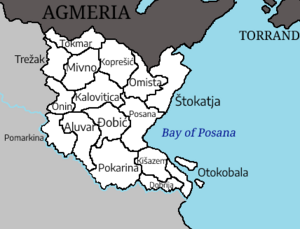
The '''counties of Kostrolia''' ( | The '''counties of Kostrolia''' ([[Kostrol language|Kostrol]]: ''kostroljske županije'') are the first-level [[Administrative divisions of Kostrolia|administrative subdivisions]] of [[Kostrolia]]. The 16 counties were established in 356 CE, following the collapse of the [[Republic of Ikhov]]. The county borders have not changed since [[Unification of Kostrolia|Kostrolian unification]], outside of the time period of the [[USSKM]]. The counties are divided into 62 [[Districts of Kostrolia|districts]]. As a {{wp|unitary state}}, the counties of Kostrolia are ultimately subject to the authority of the {{wp|central government}}, though they do possess some {{wp|Power (social and political|political power}} through {{wp|devolution}}. | ||
== List == | == List == | ||
Revision as of 18:55, 27 April 2024
| Counties of Kostrolia | |
|---|---|
| Also known as: Kostroljske županije | |
 | |
| Category | Unitary state |
| Location | Kostrolia |
| Number | 16 |
| Populations | 953,486 (Tokmar) – 8,013,497 (Posana) |
| Government | County government, National government |
| Subdivisions | District |
The counties of Kostrolia (Kostrol: kostroljske županije) are the first-level administrative subdivisions of Kostrolia. The 16 counties were established in 356 CE, following the collapse of the Republic of Ikhov. The county borders have not changed since Kostrolian unification, outside of the time period of the USSKM. The counties are divided into 62 districts. As a unitary state, the counties of Kostrolia are ultimately subject to the authority of the central government, though they do possess some political power through devolution.
List
| County | Seat | Population | GDP (PPP) | GDP (PPP) per capita | HDI |
|---|---|---|---|---|---|
| Aluvar | Aluvar | 2,224,598 | TBA | TBA | 0.941 |
| Dobrija | Vuma | 2,487,605 | TBA | TBA | 0.954 |
| Đobič | Nadsana | 1,482,343 | TBA | TBA | 0.939 |
| Kalovitica | Kalovitica | 1,539,385 | TBA | TBA | 0.936 |
| Kišazem | Zelekost | 2,070,449 | TBA | TBA | 0.940 |
| Koprešič | Crvenograd | 1,297,062 | TBA | TBA | 0.914 |
| Mivno | Mivno | 1,164,998 | TBA | TBA | 0.910 |
| Omista | Zvjezdana | 1,249,155 | TBA | TBA | 0.908 |
| Onin | Onin | 888,103 | TBA | TBA | 0.909 |
| Otokobala | Kamena | 1,494,886 | TBA | TBA | 0.937 |
| Pokarina | Zaimak-ana-Kari | 6,754,089 | TBA | TBA | 0.948 |
| Pomarkina | Kanžara | 5,403,325 | TBA | TBA | 0.946 |
| Posana | Ikhov | 8,013,497 | TBA | TBA | 0.952 |
| Štokatja | Uzobala | 2,318,697 | TBA | TBA | 0.936 |
| Tokmar | Granica | 953,486 | TBA | TBA | 0.902 |
| Trežak | Trežak | 1,075,611 | TBA | TBA | 0.903 |