Redthorpe: Difference between revisions
Jump to navigation
Jump to search
mNo edit summary |
mNo edit summary |
||
| Line 2: | Line 2: | ||
|micronation = <!--yes if a micronation--> | |micronation = <!--yes if a micronation--> | ||
|conventional_long_name = <!--Formal or official full name of the country in English--> Republic of Redthorpe | |conventional_long_name = <!--Formal or official full name of the country in English--> Republic of Redthorpe | ||
|native_name = <!--Country's name (usually full name) in its official/defacto language(s), hence in italics (double quotemarks)--> {{native name|ang|Rīce | |native_name = <!--Country's name (usually full name) in its official/defacto language(s), hence in italics (double quotemarks)--> {{native name|ang|Rīce Rēodþorp}} | ||
|common_name = <!--Common name in English (used for wikilinks, captions, and to produce a default iso3166 code)--> | |common_name = <!--Common name in English (used for wikilinks, captions, and to produce a default iso3166 code)--> | ||
|status = <!--Status of country--> | |status = <!--Status of country--> | ||
| Line 29: | Line 29: | ||
|map_caption2 = <!--Caption to place below second map--> | |map_caption2 = <!--Caption to place below second map--> | ||
|image_map2_size = <!--Map size in number of pixels--> | |image_map2_size = <!--Map size in number of pixels--> | ||
|capital = <!--Name of country/territory's capital, wikilinked if link exists--> | |capital = <!--Name of country/territory's capital, wikilinked if link exists--> Cîpe Cotlîf | ||
|coordinates = <!-- Coordinates for capital, using {{tl|coord}} --> | |coordinates = <!-- Coordinates for capital, using {{tl|coord}} --> | ||
|largest_city = <!--Name of country/territory's largest city. Use "capital" (without quotation marks) if it's the capital.--> | |largest_city = <!--Name of country/territory's largest city. Use "capital" (without quotation marks) if it's the capital.--> capital | ||
|largest_settlement_type = <!--Type of settlement if largest settlement not a city--> | |largest_settlement_type = <!--Type of settlement if largest settlement not a city--> largest city | ||
|largest_settlement = <!--Name of largest settlement--> | |largest_settlement = <!--Name of largest settlement--> | ||
|official_languages = <!--Languages recognised in legislation, constitution, etc--> | |official_languages = <!--Languages recognised in legislation, constitution, etc--> [[wikipedia:Old English|Old English]] | ||
|national_languages = <!--Country/territory-wide languages recognised but not necessarily in country/territory-wide law, etc--> | |national_languages = <!--Country/territory-wide languages recognised but not necessarily in country/territory-wide law, etc--> | ||
|regional_languages = <!--Languages recognised or associated with particular regions within the country/territory--> | |regional_languages = <!--Languages recognised or associated with particular regions within the country/territory--> | ||
| Line 125: | Line 125: | ||
|footnotes = <!--For any generic non-numbered footnotes--> | |footnotes = <!--For any generic non-numbered footnotes--> | ||
}} | }} | ||
'''Redthorpe''' officially the '''Republic of Redthorpe''' ([[wikipedia:Old English|Old English]]: ''Rīce Rēodþorp'') is a country located in West Europe, comprising {{convert|132932|km2|sqmi}} of the island of Great Britain. | |||
{{climate chart | {{climate chart | ||
| <!--- | | <!--- Redthorpe ---> | ||
|3.9|12.3|720.2 | |3.9|12.3|720.2 | ||
|7.1|14.5|1013.3 | |7.1|14.5|1013.3 | ||
| Line 133: | Line 135: | ||
|11.3|22.5|1123.0 | |11.3|22.5|1123.0 | ||
|14.8|23.0|1334.4 | |14.8|23.0|1334.4 | ||
|15. | |15.6|23.2|1524.0 | ||
|18.9|27.7|1530.6 | |18.9|27.7|1530.6 | ||
|18.9|23.0|1618.0 | |18.9|23.0|1618.0 | ||
|15. | |15.3|21.4|1719.0 | ||
|11.3|20.5|1752.6 | |11.3|20.5|1752.6 | ||
|7.3|16.4|1785.8 | |7.3|16.4|1785.8 | ||
Revision as of 20:13, 7 July 2024
Republic of Redthorpe Rīce Rēodþorp (Old English) | |
|---|---|
| Motto: Gloria in excelsis Deo et in terra pax hominibus eius (Latin) Glory to God in the highest, and peace to His people on Earth | |
 | |
| Capital and largest city | Cîpe Cotlîf |
| Official languages | Old English |
| Religion | Protestantism (official) |
| Currency | Pound sterling |
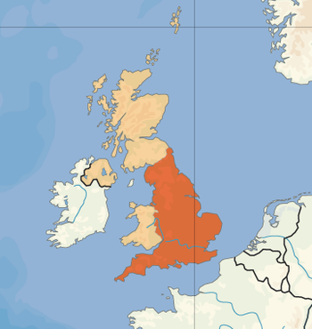
Redthorpe officially the Republic of Redthorpe (Old English: Rīce Rēodþorp) is a country located in West Europe, comprising 132,932 square kilometres (51,325 sq mi) of the island of Great Britain.
| Climate chart (explanation) | ||||||||||||||||||||||||||||||||||||||||||||||||||||||||||||
|---|---|---|---|---|---|---|---|---|---|---|---|---|---|---|---|---|---|---|---|---|---|---|---|---|---|---|---|---|---|---|---|---|---|---|---|---|---|---|---|---|---|---|---|---|---|---|---|---|---|---|---|---|---|---|---|---|---|---|---|---|
| ||||||||||||||||||||||||||||||||||||||||||||||||||||||||||||
| ||||||||||||||||||||||||||||||||||||||||||||||||||||||||||||