Asterhaf: Difference between revisions
| Line 33: | Line 33: | ||
===Cetaceans=== | ===Cetaceans=== | ||
===Fish=== | ===Fish=== | ||
===Seals and Walruses=== | |||
===Otters and beavers=== | |||
Revision as of 18:36, 16 August 2024
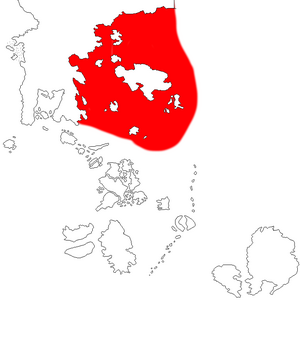
Asterhaf (lit; The eastern sea) is a large ocean region to the east of Scandera and north west of Asterland, it is also known by the names Nardsja, svarthaf, Kakto Dour, Ishashi'mo (literally, the norhtern sea, the black ocean, the norhtern ocean, or the Sahsi/Scanderan sea) and it is very much considered federal waters by the federation but it does not enforce as an extreme claim to the open ocean as it does to the entirety of Vattnafalten as they do in the south and they don't enforce it as their entire EEZ. The ocean is located aroun Scandera, especially Imeriata proper, Vedian, and the northern ice plains to the east, surrounding Asterland, and Salywa centrally and in the south can one find the island of the dragon grave, Taranaka, and Salmo to the south and to the far north can one find the Cairn shore.
The sea is noted for being very deep in it's centre with tectonic plates slowly driving Asterland away from Scandera resulting in a very deep sea and is the home of the leviathan whales that the sea is known for and submerged volcanos are common and has resulted in several small island chains dotting the region home to mostly Scanderans, Scanderiansied natives, Giels, or even smaller ethnic groups that are just commonly lumped in as mere "Havsavalk" by federal authorities however these peoples are quite rare in modern times as Scanderianisation have historically either assimilated such groups or replaced them with scanderan settlers over several centuries.
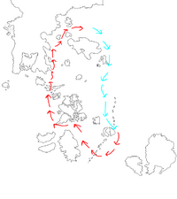
Economically and military is the region very important and serve as a large transport hub between Asterland, and Salywa and Scandera itself but it remains far from as well used as the Vattnafalten. Historically have the ocean been very important for the people living around the sea and trade between Asterland and Scandera have always travelled from the north to the Scanderan Northern iceplains before they turned south around Aserstrand. Even today is fishing and whaling very important industries for the region but oil drilling have recently also sprung up as an economic activity in the region. Militarily does it provide the Federal and royal fleet with massive naval bases dotted around it to ensure federal control over the region and ability to strike south to defend Vattnafalten without any danger from powers of federal technological levels.
Geography
The geography of the region is due to two factors, the divergent continental drift from the south Scanderan and Asterland continental shelves that have given birth to the very deep ocean between Scandera and Austland but also the warm Vattnafalt stream that brings warm ocean water from the south and brings down cold ocean water to the eastern Vattnafalten. This is responsible for the heavy rainfall on the eastern Scanderan coast and the temperate and artic rainforests that one can find there. From the Islands can one also find large meltwater runoffs that provides the sea with minerals and causes yearly algae blooms that contributes to large fish gathering on the coast to feast and in turn invigorates the ecosystem.
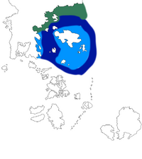
This has divided the sea into five distinct regions, the northern kelp forests, the dense pine mangroves of eastern Scandera, the shallows of Asterland, the volcanic islands, and finally the deep black sea. Each of these regions are however connected through the sea and affects the wildlife that often migrate between them in large titanic schools.
Scanderan Coast
The Scanderan coast is a very long and shallow region, home of a lot of either kelp forests or large pine mangrove forests and the home of a lot of bio diverse species, fish, seals, walruses, whales and dolphines, bears, and other semi and fully aquatic mammals make their homes there and it's also the home of some species of northern sea lizards but these tends to be very few in numbers compared to Vattnafalten to the south.
The Cairn shore
The absolute north of Asterhaf ends in the chilly shores that is simply called "The cairn shore" or "Brasstrand" is a chilly artic land of rocks and snow and is the home of a thick massive kelp forest to the far north that serves as the home of numerous walruses, dolphins, seals, smaller whales, fish, crustaceans, octopi, and sea lizards that either feeds on the large kelp or on those that feeds on the herbivores. The rocky shore has however historically been the home of three different civilisations. The ancient pyramid builders that nothing is known about but their ruined cities and large step pyramids still litter the coast and most federal researchers suggest was an ancient human civilisation from before even the dawn age, however it is assumed that they were destroyed by the Wharen alongside the golem builders of the broken back islands.
Much younger are the so called cairn builders that was a group of peoples that used to build large burial cairn necropolises and Scanderans interacted with until the end of the 16th century when they were finally driven away and vanquished as they practiced vile necromantic arts and often drew ships into the shore with fake pyres afterwards they tended to feast on any corpses and they build burial cairns for their dead, all crimes that none from the civilised south could tolerate. Modern people that far north are far between but remains under federal control, they speak queer tongues and worships in the chronological manner or follows a stern winter father God and his ocean wife and practises kremation.
Eastern shallows
The eastern shallows is the region around asterland and can cover either shallow sandbanks, seagrass meadows, kelp forests but also just open sea that just lacks the abysmal depth of the deep sea.
Islands
Most of the islands found between Scandera and Asterland is volcanic in nature, they tend to be very small and rising out as large pillars from the sea making these areas are often very fertile with large birch forests cover the fertile volcanic soil. Similarly do they cause large meltwater to pour into the sea every spring and summer that causes large algae bloom and massive population blooms of huge schools of fish that feasts on these algae which in turn causes annual migration of predatory fish and mammals from the coast out into the deep waters to feast either on the fish, the algae, or the migrants.
The most noteworthy of these island is the island simply named "The grave of the dragon" that while large stands mostly uninhabited bar some minor religious orders and federal military outposts, the thing that truly makes it noteworthy however is the large fossilised bones of a gigantic sea dragon of horrific proportions that lays on the island and has given it it's foul reputation as tainted and unholy. Most federal subjects stay clear of this island and even historically have trade routes that would have saved weeks of their journeys and could have used the island as a natural harbour and refueling station have still stayed clear of it.
Deep Sea
The region most thought of when most federal talk about the Asterhaf is it the deep sea they think of and its deep sea, this is a very deep region due to the continental divergence occurring between Scandera and Asterland and as a result is it the home of large very deep trenches, volcanic activity is high and one can find numerous volcanic island chains dotting the deep sea as large pillars. This is also the home of the largest of the animals of the sea and one can find massive filterfeedeing whales and sharks that travels the deep ocean but also massive macro predatory whales, large kraken squids, and sea dragons that hunts these giants. This has historically also traditionally kept sea exploration on the deep sea somewhat limited and very dangerous and instead forced sea crossings to go north before heading south. However modern ships are generally safe from attacks from these giants even if danger is still present if one would underestimate them.


