Balatonlota: Difference between revisions
Jump to navigation
Jump to search
(Created page with "{{Infobox settlement | name = Balatonlota | settlement_type = City | image_skyline = Basen-portowy-gdynia.jpg | subdivision_type = Country | subdivision_name = Rettoa | area_total_km2 = 307.36 | area_land_km2 = | area_water_km2 = | area_water_percent = | area_urban_km2 = 1587 | area_rank = | elevation_footnotes = | elevation_m =...") |
No edit summary |
||
| Line 2: | Line 2: | ||
| name = Balatonlota | | name = Balatonlota | ||
| settlement_type = City | | settlement_type = City | ||
| image_skyline = | | image_skyline = Zimný_prístav_(Bratislava)_2019.jpg | ||
| subdivision_type = Country | | subdivision_type = Country | ||
| subdivision_name = [[Rettoa]] | | subdivision_name = [[Rettoa]] | ||
Latest revision as of 23:42, 1 September 2024
Balatonlota | |
|---|---|
City | |
 | |
| Country | Rettoa |
| Area | |
| • City | 307.36 km2 (118.67 sq mi) |
| • Urban | 1,587 km2 (613 sq mi) |
| Elevation | 10 m (30 ft) |
| Population | |
| • City | 212,187 |
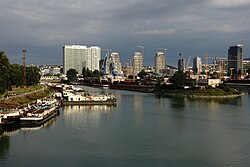
Balatonlota is the sixth-largest city of Rettoa, with 212,000 inhabitants. It is located on the island of Lota in the Vasilin Sea, at the mouth of the Vasi Strait, and as such is an important seaport.