Haramoun: Difference between revisions
Jump to navigation
Jump to search
mNo edit summary |
No edit summary |
||
| Line 10: | Line 10: | ||
| other_symbol_type = | | other_symbol_type = | ||
| other_symbol = | | other_symbol = | ||
| image_map = | | image_map = | ||
| alt_map = | | alt_map = | ||
| map_caption = | | map_caption = | ||
| Line 17: | Line 17: | ||
| map_caption2 = | | map_caption2 = | ||
| capital = Berytus | | capital = Berytus | ||
| largest_city = | | largest_city = Tyra | ||
| largest_settlement = | | largest_settlement = | ||
| largest_settlement_type = | | largest_settlement_type = | ||
Revision as of 08:06, 9 October 2024
Christian Republic of Haramoun جمهورية الحرمون المسيحية (Arabic) | |
|---|---|
|
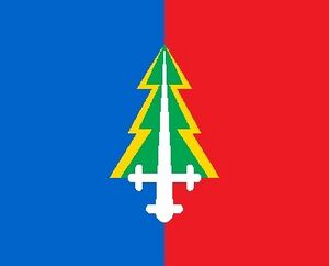
Flag | |
| Motto: For God, Family and Nation | |
| Anthem: [1] "Mawtini" Link to Anthem (with Lyrics) | |
| Capital | Berytus |
| Largest | Tyra |
| Recognised national languages | Arabic, English, French, Greek, Farsi |
| Ethnic groups | 95% Arabo-Aryan (Haramunean Arab), 28% Romaian, 20% Isfahani, 10% Other |
| Religion | 92% Semaanite Christianity, 24% Romaian Orthodox, 28% Islam |
| Demonym(s) | Haramounean |
| Government | Christian Republic |
| Legislature | Parliament |
| Population | |
• 2013 estimate | 6,258,619 |
| Currency | Haramounean Lyra (£L) (HL) |
| Date format | dd-mm-yyyy |
| Driving side | left |
| Calling code | +961 |
| ISO 3166 code | HAR |
Haramoun, formally known as the Christian Republic of Haramoun (Arabic: جمهورية الحرمون المسيحية ) is a medium sized country situated in the Arabian region of Hausa. It borders Romaia to the North, Memphia to the South and Isfahan to the East. It has a population of around 6.23 million according to the 2016 census.
The Haramunean people and country have had a long and proud history, human civilization in Haramoun dates to about 5000 BC. From 3200 to 593 BC, it was part of the Phoinikean Empire.
