Lÿndow Island: Difference between revisions
Jump to navigation
Jump to search
Posadastan (talk | contribs) |
Posadastan (talk | contribs) |
||
| Line 80: | Line 80: | ||
==Gallery== | ==Gallery== | ||
<gallery> | |||
Beerenberg JanMayen.JPG|Distal view of Lÿndow Island. | |||
Edinburgh of the Seven Seas 01.jpg|View of Lÿndowberg. | |||
Maria S. Merian vor Tristan da Cunha.jpg|Ship off of the coast of Lÿndow Island. | |||
</gallery> | |||
==Economy== | ==Economy== | ||
Revision as of 17:17, 23 December 2024
This article is incomplete because it is pending further input from participants, or it is a work-in-progress by one author. Please comment on this article's talk page to share your input, comments and questions. Note: To contribute to this article, you may need to seek help from the author(s) of this page. |
Lÿndow Island | |
|---|---|
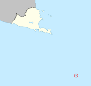
 Location of Lÿndow Island in the Galanic Ocean | |
| Sovereign state | |
| First settlement | 1807 |
| Ruthish Confederation rule asserted | 16 November 1807 |
| Current constitution | 15 April 1984 |
| Capital and settlement | Lÿndowberg |
| Official languages | Borvazunge Ruthish Seloleme Ulwimi |
| Leaders | |
| Kagiso Motsepe | |
• Governor | Kael Kopfrkingl |
| Legislature | Legislative Council |
| Area | |
• Total | 497.9 km2 (192.2 sq mi) |
| Population | |
• 2022 census | 857 |
| Currency | Gauta (Ǥ) (BSG) |
| Time zone | UTC+00:00 |
| Driving side | right |
| Internet TLD | .bs |
Lÿndow Island is an outlying island belonging to Borvastaat, located in between the South Medan and Galanic oceans and about 1,920km from mainland Borvastaat. The island is named for Ruthish explorer Ludeke von Lÿndow who discovered the island in 1690. However, human habitation was not made until the 18th century, with sporadic whaling settlements being established. The first year-round permanent settlement was that of Lÿndowberg in 1807, when a group of Ruthish settlers sought to consolidate the Ruthish claim over the island.


