Gregahou
This article is incomplete because it is pending further input from participants, or it is a work-in-progress by one author. Please comment on this article's talk page to share your input, comments and questions. Note: To contribute to this article, you may need to seek help from the author(s) of this page. |
Commonwealth of Greğahou Sodruz Greğahouğanskiy | |
|---|---|
|
Flag | |
| Motto: Ot tsakasa prikhodit şvoboda (Gregahouvian) "From order comes freedom" | |
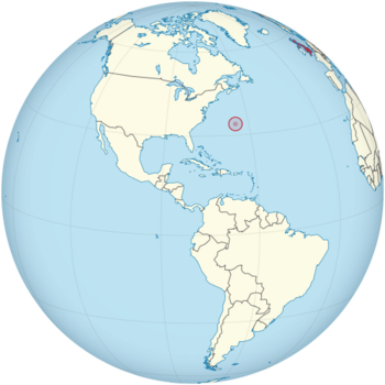
 Location of Gregahou (red) in the Western Hemisphere | |
| Capital and largest city | Stolitsemlağa |
| Official languages | Gregahouvian English |
| Recognised regional languages | French (in Porte Nouvelle) |
| Ethnic groups (2016) | 57.7% Tatar 22.9% Chechen 4.3% Turkmen 3.8% Bashkir 11.3% others |
| Demonym(s) | Gregahouvian |
| Government | Unitary presidential republic |
• President | Imat Ilva |
• Prime Minister | Yohan Varayev |
| Legislature | Zdaniye Parlamentiy |
| Vyşa Dom | |
| Nizhiy Dom | |
| Independence from the Soviet Union | |
• Declaration | May 3, 1981 |
• Establishment as sovereign | May 12, 1981 |
• Establishment as Gregahou | July 2, 1981 |
| Area | |
• Total | 7,798 km2 (3,011 sq mi) |
| Population | |
• 2018 estimate | 3,539,805 (129th) |
• Density | 453.9/km2 (1,175.6/sq mi) |
| GDP (PPP) | estimate |
• Total | 13,323 (in US$ millions) |
• Per capita | $15,989 |
| Gini (2016) | 31.3 medium (31st) |
| HDI (2018) | 0.858 very high (35th) |
| Currency | Kadz (₭) (KDZ) |
| Time zone | UTC-5 (EST) |
| Date format | dd/mm/yyyy |
| Driving side | right |
| Calling code | +522 |
| ISO 3166 code | GO |
| Internet TLD | .go |
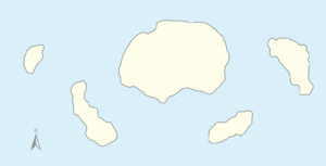
Gregahou (pronounced /greɪjɑhu/), officially the Commonwealth of Gregahou (Gregahouvian: Sodruz Greğahouğanskiy) is an island nation located in the Atlantic Ocean, approximately 1,100 km due east of Buxton, North Carolina; 1,250 km due south of Nova Scotia; and 1,780 km north-east of Cuba. Though typically referred to in the singular, the nation's landmass of 7,798 square kilometers (3,010 square miles) is separated between 6 islands, including its one sovereign protectorate, Porte Nouvelle. With an estimated population of 3,539,805, Gregahou is the 129th most populous country. The capital city is Stolitsemlağa.
Russian oil giant Tatneft ordered the construction of an oil rig off the coast of the country's largest island, then uninhabited, in 1954, and colonization began in 1955. Numerous disputes between workers sent to the colony and Tatneft in addition to a lack of strong government presence in the archipelago led to a war for independence lasting between 1972 and May of 1981, when electricity was shut off to the final operational oil rig. By 1981, the colony was fully modernized, but lack of funding proved difficult for progress in early independent Gregahou, and the country emerged from its war for independence in poverty.
History
Geography
The archipelago is a series of low forming volcanoes in the Atlantic Ocean, on the western edge of the Sargasso Sea. Ostrov Novağa-Zemliğa is the largest island of the archipelago, and notably the most rugged in terrain, containing the nation's highest peak at Velağa-Gora (English: White Mountain). Other than on the largest island, the terrain is relatively low-lying and flat, with the second highest peak at just 191m (626ft). The most populous island is Ostrov Stolitsa, which, with over 1 million inhabitants, represents over one-third of the country's total population. Together with Bermuda, the limestone islands make up the Western Atlantic ecoregion, with the Gregahouvian archipelago being the most populated part of the region.
Climate
Gregahou has a humid subtropical climate (Köppen climate classification: Cfa), and is warmed by the Gulf Stream and relatively low latitude. The archipelago usually experiences cooler temperatures in the winter months, and temperatures in January generally average 17°C (63°F). However, there has never been a snowfall or freeze on record in Gregahou, even at its highest peak. In the summer months, temperatures rise considerably, but daily highs usually do not exceed 29°C (85°F). In August, at the peak of summer, ocean water temperatures at the beaches in the country's capital average 28°C (82°F), and are usually slightly cooler in the country's northernmost coast.
| Climate data for Stolitsemlağa - capital of Gregahou (National Airport) 2000–2010 | |||||||||||||
|---|---|---|---|---|---|---|---|---|---|---|---|---|---|
| Month | Jan | Feb | Mar | Apr | May | Jun | Jul | Aug | Sep | Oct | Nov | Dec | Year |
| Record high °C (°F) | 25.4 (77.7) |
26.1 (79.0) |
26.1 (79.0) |
27.2 (81.0) |
30.0 (86.0) |
32.2 (90.0) |
33.1 (91.6) |
33.9 (93.0) |
33.2 (91.8) |
31.7 (89.0) |
28.9 (84.0) |
26.7 (80.0) |
33.9 (93.0) |
| Average high °C (°F) | 20.7 (69.3) |
20.4 (68.7) |
20.8 (69.4) |
22.2 (72.0) |
24.6 (76.3) |
27.5 (81.5) |
29.7 (85.5) |
30.1 (86.2) |
29.1 (84.4) |
26.7 (80.1) |
23.9 (75.0) |
21.7 (71.1) |
24.8 (76.6) |
| Daily mean °C (°F) | 18.3 (64.9) |
18.0 (64.4) |
18.2 (64.8) |
19.6 (67.3) |
22.0 (71.6) |
25.0 (77.0) |
27.2 (81.0) |
27.6 (81.7) |
26.6 (79.9) |
24.4 (75.9) |
21.6 (70.9) |
19.5 (67.1) |
22.3 (72.2) |
| Average low °C (°F) | 15.8 (60.4) |
15.4 (59.7) |
15.8 (60.4) |
17.2 (63.0) |
19.8 (67.6) |
22.8 (73.0) |
24.9 (76.8) |
25.1 (77.2) |
24.3 (75.7) |
22.1 (71.8) |
19.3 (66.7) |
17.2 (63.0) |
19.9 (67.9) |
| Record low °C (°F) | 7.2 (45.0) |
6.3 (43.3) |
7.2 (45.0) |
8.9 (48.0) |
12.1 (53.8) |
15.2 (59.4) |
16.1 (61.0) |
20.0 (68.0) |
18.9 (66.0) |
14.4 (58.0) |
12.4 (54.3) |
9.1 (48.4) |
6.3 (43.3) |
| Average precipitation mm (inches) | 139 (5.47) |
124 (4.87) |
120 (4.72) |
106 (4.17) |
89 (3.52) |
120 (4.71) |
132 (5.21) |
162 (6.38) |
129 (5.09) |
160 (6.31) |
99 (3.88) |
110 (4.33) |
1,490 (58.66) |
| Average precipitation days (≥ 0.01 inch) | 18 | 16 | 16 | 12 | 10 | 11 | 13 | 15 | 14 | 15 | 14 | 15 | 169 |
| Average relative humidity (%) | 73 | 73 | 73 | 74 | 79 | 81 | 80 | 79 | 77 | 74 | 72 | 72 | 76 |
| Mean monthly sunshine hours | 142.9 | 144.5 | 185.7 | 228.1 | 248.1 | 257.2 | 281.0 | 274.1 | 220.1 | 197.5 | 170.3 | 142.5 | 2,492 |
</ref>[1]
|date=October 2011}}
The archipelago is in the hurricane belt, and is often in the direct path of hurricanes as they begin to reach the westerlies, but direct landfall is rare due to the common nature of hurricanes to curve northward and weaken before direct landfall on North America. Additionally, the archipelago's small size means that direct hits are very uncommon.
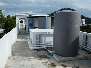
As the archipelago has no freshwater rivers or lakes, the only source of fresh water is rainfall, which is collected for consumption using roof gutters and catches and is stored in tanks usually either in the house's foundation or on the roof. Every residence is required by national law to have at least one tank piping rainwater down from the roof of the building. Rainfall is generally highest in fall, with monthly averages peaking in October.
Flora and fauna
Until the 1950s, the archipelago was uninhabited and mostly overrun with forests. Because of its isolation in the Atlantic Ocean, Gregahou is home to an interesting array of native flora, including the Bermuda cedar, which is endemic to the ecoregion, as well as fourteen other species of plants. Due to its semi-tropical climate, new flora were easily introduced by the islands' first settlers, and currently, much of the country's fruit supply is grown nationally. Palm trees, while not originally native to the islands, also now grow very commonly and are often used decoratively.
Politics
Subdivisions
Protectorates
Foreign relations
Military
Economy
Currency
Energy
Transport
Demographics
Population distribution
Ethnicity
Religion
Education
Culture
Cuisine
Sports
- ↑ "Bermuda's Climatology 1949–1999". Bermuda Weather Service. Archived from the original on 14 December 2018. Retrieved 13 December 2018.


