Chutorozen
Jump to navigation
Jump to search
Chutorozen | |
|---|---|
| Anthem: "抜刀隊" Battōtai (English: "Drawn-Sword Regiment") | |
 | |
| Capital | Dorayaki-kyō |
| Official languages | Japanese |
| Religion | Shintō |
| Demonym(s) | Chutorozenese |
| Government | Unitary one-party socialist republic under an autocrazy |
• Supreme Leader | Nobita Nobi |
• Chairman of Chutorozen Socialist Workers' Party | Nobisuke Nobi Jr. |
| Currency | Onigiri (お/CTO) |
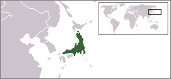
Chutorozen officially the State of Chutorozen is an island country in East Asia. It comprises of 34 prefectures and subdivided in , 5 regions. It's capital and largest city is Dorayaki-kyō.
Geography
Climate
| Climate data for Dorayaki-kyō | |||||||||||||
|---|---|---|---|---|---|---|---|---|---|---|---|---|---|
| Month | Jan | Feb | Mar | Apr | May | Jun | Jul | Aug | Sep | Oct | Nov | Dec | Year |
| Average high °C (°F) | 15.1 (59.2) |
17.2 (63.0) |
17.3 (63.1) |
18.4 (65.1) |
20.5 (68.9) |
22.6 (72.7) |
24.7 (76.5) |
22.8 (73.0) |
21.9 (71.4) |
19.0 (66.2) |
18.1 (64.6) |
15.2 (59.4) |
19.4 (66.9) |
| Daily mean °C (°F) | 12.5 (54.5) |
14.1 (57.4) |
14.2 (57.6) |
15.3 (59.5) |
17.4 (63.3) |
18.5 (65.3) |
19.6 (67.3) |
18.2 (64.8) |
17.3 (63.1) |
15.7 (60.3) |
15.0 (59.0) |
13.1 (55.6) |
15.9 (60.6) |
| Average low °C (°F) | 10.0 (50.0) |
11.1 (52.0) |
11.2 (52.2) |
12.3 (54.1) |
14.4 (57.9) |
14.5 (58.1) |
14.6 (58.3) |
13.7 (56.7) |
12.8 (55.0) |
12.5 (54.5) |
12.0 (53.6) |
11.1 (52.0) |
12.5 (54.5) |
| Average precipitation mm (inches) | 11.1 (0.44) |
32.2 (1.27) |
60.3 (2.37) |
65.4 (2.57) |
78.5 (3.09) |
94.6 (3.72) |
99.7 (3.93) |
94.8 (3.73) |
57.9 (2.28) |
37.0 (1.46) |
32.1 (1.26) |
22.2 (0.87) |
685.8 (26.99) |
| Source: [NAME OF THE WEBSITE] | |||||||||||||